Main Navigation

Manaslu Tilicho Lake Annapurna Circuit Trek is a lengthy but highly rewarding trek in western Nepal. It takes you around the world’s eighth highest peak, Manaslu (8163m), all the way up to the alpine freshwaters of Tilicho and ends in the lakeside city of Pokhara as you explore the pristine regions and scenic views around Annapurna.
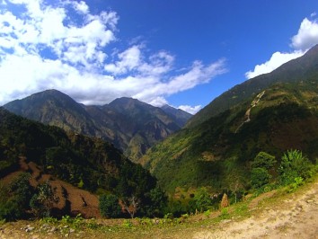
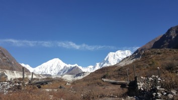
The Manaslu Himal rises in the north of the Gorkha District in mid-western Nepal. The trekking region contains some of the most beautiful and dramatic scenery in the Himalaya. The south is peopled by Hindu Newars and Buddhist Gurungs; the north is home to an old Gurung and a Tibetan community: speaking two independent dialects. Engaging in this rich cultural mix is one of the highlights of this trek.
The Manaslu topography demands much up and down walking, making the trail quite demanding: and calling for good initial fitness. The up route passes through natural forest and farmland. The valley gradually curves to the west between dramatic mountain ranges to the north and south. Manaslu is first revealed on the 8th day. A rest day at Samagaon offers a visit to the Pungyen Nunnery below Manaslu or a walk to Manaslu Base Camp. A three day trek then leads to the Larkya La (5 160m/16 930ft) beyond which the trail drops into the Annapurna Region through dramatic glacial scenery.
The trekking trail descends through forest, then agricultural land along the Dudh Khola. At Thonje this meets the Marsyangdi Khola that drains the Tilicho Tal (Lake) and upper Manang Valley. We follow it, NW, for six days to its source. Notable landmarks along the trail include: the Upper Pisang to Braga trail which offers fascinating architecture and spectacular views of Annapurna II and IV. The road-head and largest village of Manang, has perfect views of Gangapurna and Annapurna III. The town also panders to ‘tourist tastes.’
From Manang the Tilicho Tal trail follows the westward Marsyangdi Valley to its source at the lake. The trail climbs into the heart of the Annapurna – Nilgiri – Muktinath Himal with closer views of these ice giants. An easy first day is followed by two days that traverse eroded scree slopes and while not difficult they require a head for heights and great caution. The reward is the beautiful turquoise of the lake (if not iced over late in the year).
Return to Khangsar and a shortcut across to Yak Kharka on the high pass trail to the Thorung La (5 416m/17 770ft). Beyond the pass is Muktinath, sacred to Hindus and Buddhists, in the impressive Kali Gandaki Valley. Jeep down to Tatopani: then return to glorious forested trails that lead to Poon Hill for frontal views of the range. Descend to Pokhara, Nepal’s lakeside playground city.
The best time to perform the Manaslu Tilicho Lake Annapurna Circuit Trek is during the spring (March - May) and autumn (September - November) seasons. This trek offers some of the most breathtaking sights and scenery in all of Nepal, which you will be able to fully savor during these periods. This is because these months usually have stable weather, moderate temperature and clear skies leading to the best views with an easier trekking experience.
The 34 day Manaslu Tilicho Lake Annapurna Circuit Trek is a lengthy and physically exhausting trek. Although no technical climbing skills are required for this trek, it is recommended to have some prior trekking experience due to the sheer length of the trek. Good physical fitness and stamina is also necessary.
Day 01: Arrival Kathmandu Tribhuvan Airport (1 300m/4 260ft). We will meet and transfer you to your hotel.
Day 02: In the City Kathmandu Valley Sightseeing Tour OR A day at leisure. Trek preparation.
Day 03: Kathmandu – Arughat (670m/2 200ft) – Soti Khola (710m/2 330ft), 135km, 8-9 hrs drive
Day 04: Soti Khola – Machha Khola (890m/2 920ft), 6-7 hrs
Day 05: Machha Khola – Dobhan (1 000m/3 280ft), 6-7 hrs
Day 06: Dobhan – Philim (1 590m/5 220ft), 6-7 hrs
Day 07: Philim – Deng (2 360m/7 750ft), 6-7hrs
Day 08: Deng – Namrung (2 660m/8 730ft), 6-7 hrs.
Day 09: Namrung – Lho (3 180m/10 430ft), 4-5 hrs
Day 10: Lho – Sama Gaon (3 530m/11 580ft), 5-6 hrs
Day 11: Sama: Rest and exploration day: Birendra Tal / Pungyen Gompa / Manaslu Base Camp
Day 12: Sama – Samdo (3 860m/12 660ft), 3-4 hrs
Day 13: Samdo – Dharamsala/Larkya Phedi (4 460m/14 630ft), 3-5 hrs
Day 14: Dharamsala – Larkya La (5 160m/16 930ft) – Bimthang (3 720m/12 200ft), 7-9 hrs
Day 15: Bimthang – Gho (2 560m/8 400ft), 5-6 hrs
Day 16: Gho – Chame (2 710m/8 890ft), 5-6 hrs
Day 17: Chame – Pisang (3 240m/10 630ft), 5-6 hrs
Day 18: Pisang – Ngawal (3 660m/12 010ft), 4-5 hrs
Day 19: Ngawal – Manang (4 020m/13 190ft), 3-4 hrs
Day 20: Manang: Acclimatisation and exploration day
Day 21: Manang – Khangsar – Shree Kharka (4 050m/13 290ft)3-4 hrs
Day 22: Shree Kharka – Tilicho Tal Base Camp Hotel (4 140m/13 580ft) 4-6 hrs
Day 23: Tilicho Tal BC – Tilicho Tal (4 920m/16 140) – Khangsar (3 750m/12 300ft), 9-10 hrs
Day 24: Khangsar – Yak Kharka (4 020m/13 190ft), 4-6 hrs
Day 25: Yak Kharka – Thorung Phedi (4 540m/14 900ft), 3-4 hrs
Day 26: Thorung Phedi – Thorung La (5 416m/17 770ft)– Muktinath (3 800/12 470ft), 8-9 hrs
Day 27: Muktinath – Tatopani (1 190m/3 900ft), 6-7 hrs drive
Day 28: Tatopani – Ghorepani (2 870m/9 420ft), 7-8 hrs
Day 29: Ghorepani – Poon Hill (3 210m/10 530ft) – Tadapani (2 630m/8 630ft), 6-7 hrs
Day 30: Tadapani – Ghandruk (1 940m/6 370ft), 3-4 hrs
Day 31: Ghandruk – Pothana (1 990m/6 530ft), 5-6 hrs
Day 32: Pothana – Dhampus Phedi (1 130/3 710ft) – Pokhara (880m/2 900ft), 3-4 hrs, 25 min drive
Day 33: Pokhara – Kathmandu (1 300m/4 260ft), 25 min flight
Day 34: Final Departure Transfer to Tribhuvan International Airport for your flight to your next destination.
After completing passport, immigration and visa requirements, we will meet you outside the terminal building (look for your name board) and transfer you to your hotel: afternoon free. Evening: a welcome dinner, introduction to your guide and a briefing on the trek with a check on necessities. Overnight at hotel.
Take a day tour to five of the Kathmandu Valley’s cultural world heritage sites: Swayambhunath, the famed “monkey temple”; the city’s historical Durbar Square with ancient temples, unique art and architecture, plus the chance to see the Kumari (living goddess); Patan’s Durbar Square; the Hindu temple Pashupatinath and Bouddhanath, the world’s largest stupa.
A car and driver will take you to each site-entrance and wait for you. (Entry tickets and lunch are not included.)
Drive west from Kathmandu towards Pokhara through Middle Hill rural communities to Malekhu. Cross the Trisuli Nadi and head north to Dhading Besi. A slow, rutted, dirt road then heads NW: over the Gola Bhanjyang (with panoramic views of the Baudha and Ganesh Himals).
(Beyond this occasional views of Ganesh IV and VI will be seen above the valley walls as far as Khorlabesi. Shringi Himal appears from Salleri to Philim, from where Baudha Himal is also visible. Manaslu is first seen on the walk up to Lho.)
Drive on to Arughat and the Budhi Gandaki that drains the Manaslu–Tsum region. A further ~3 hrs drive up the west bank leads to Soti Khola. Overnight in Soti Khola.
The Budhi Gandaki’s rise from the glaciers NW of the Larkya La; gathers runoff from tributaries, including the Siyar Khola from Tsum. Considerable water is added by the Tum Khola from the Tibetan highlands. The resulting outflow has cut more steeply into the rising ranges than in most other regions. Thus the lower trail must negotiate the steep sided main gorge, and numerous incoming tributaries: with exposed cliff-face trails and vertical-switchback paths.
Today’s generally narrow trail undulates upwards through Sal forests and terraced ridges passing countless waterfalls. At times it clings to cliff faces or drops through rice paddies to the river gravels. Labubesi (880m) is an attractive Gurung village before the spectacular Nauli Falls and a long suspension bridge. Beyond, the valley broadens, the river flows more peacefully and the trail follows the bar to Machha (fish) Khola. Overnight in Machha Khola.
Cross the Thado Khola, descend stone stairs then follow the bar to Khorlabesi (970m, coffee and tobacco crops). The GHT trail through Gorkha (and Barpak, epicentre of the first quake on 25/04/15) crosses our trail, heading east from Manaslu to the Langtang then Everest regions.
Enter a lush narrow gorge constricting the river’s progress. Cross a landslide with a dicey path, before the three hot spring spouts in Tatopani (930m). Climb a ridge then cross the Budhi Gandaki (to avoid a cliff face and waterfalls). A staircase then leads to a landslide before climbing to a ridge; and Dobhan. Overnight in Dobhan.
Exit over the Dobhan Khola, then follow the east bank to the hamlet of Thulo Dhunga (1 840m); above cataracts. Later the gradient lessens, the valley opens and the water is placid at Yaruphant (1 170m). Cross the Yaru Khola (from Ganesh II and VI) on an old suspension bridge then climb to the teahouses at Thado Bharyang. Cross back to the west bank and ascend gently to the old paved village of Jagat (1 410m): entrance and checkpoint to the Manaslu Conservation Area.
Cross a tributary before a cliff-side trail to Salleri: with views of Shringi Himal (7 187m) to the north. Descend to Sirdibas; and the first symbols of Buddhist culture. A final bridge beyond Ghatta Khola (1 480m, water mills) to the east bank, leads to a steep climb up to Philim: a prosperous Gurung village set amongst millet and maize fields; see the Chholing Sandu Gompa. Overnight in Philim.
The trail winds through scrub and lush grasses up the beautiful narrowing valley to the high millet fields of Chisopani, then Ekle Bhatti (1 600m, one house). Gradually descend, past a spectacular waterfall, into the narrow lower gorge: and a junction, left to ‘New Bridge’ and the Larkya La, (right to the Tsum Valley).
Cross the bridge and follow the trail as it curves NW into the Manaslu Valley. A broader trail gradually rises, through bamboo forest to Deng [1 800m, entry to Kutang/Lower Nupri (‘Nubri,’) - within Tibet until the 1840s]. The people are Gurungs who speak a unique dialect, practice Buddhism and still trade with Tibet. Overnight in Deng.
Cross to the E bank and climb to Rana (1 980m). Tight switchbacks end at a log-bridge tributary-crossing before an isolated water mill. The trail then gently descends to Bihi Phedi; still high above the river.
Undulate above the river before dropping to cross the Serang Khola (far below the Serang Gompa) and later enter an S-bend between basalt walls. Rocky crags rise to the E, with a waterfall high above fields of wheat and maize. The valley broadens as it curves W: cross to the S bank shortly before a kani into attractive Ghap (2 250m); for lunch.
Ascend, through bamboo and bird-filled forests. Cross to the N bank past sheer rocky walls. The river then becomes constricted by hard rock; a short wooden bridge (over a natural rock tunnel) returns to the south bank as the water thunders below. A steep 1 hr trail leads up and away from the river to Namrung. En-route are views of the substantial Tum Khola from the Tibetan highlands: that adds its volume to the lower river at its (unseen) confluence. Namrung is a permit checkpoint. Overnight in Namrung.
This is the entrance to Upper Nupri (western mountains). Its people, formerly from Tibet, speak a unique dialect, favour chubas as common dress and continue to trade with Tibet.
The trail through maize and barley fields to Barsam is gentle. (Night guard towers, manned to scare off marauding bears, dot fields from Deng to Shrip). Climb more steeply to Lihi (2 900m, homes are grouped in clusters beneath one shingled roof). Ganesh II appears east of the valley and landmark chortens herald views of Himal Chuli (7 893m) south of the trail.
The trail then enters a side valley, crosses the Hinang Khola (and a trail to the Himal Chuli BC). It climbs steeply to a detailed chorten land marking the ice walls of Himal Chuli to the south. Beyond are the clustered houses fields and apple orchards of Sho (2 960m). Good views continue as the trail ascends to the hamlet of Shrip.
From Shrip, the trail curves up towards Lho: and reveals the 8th highest peak: Manaslu (8 156m/26 760ft, which, from the Sanskrit manasa – ‘intellect’ or ‘soul’ gives ‘Mountain of the Spirit’); Manaslu North and Naike Peak. A steep climb ends on the ridge in the attractive village of Lho.
The stone houses are shingled and many have distinctive wooden decks. The imposing Ribung Monastery above the village houses ~150 monks. A kani beyond the village, past an ancient mani wall and chortens, offers the best spot for dusk and dawn pictures. Overnight in Lho.
The Budi Gandaki flows deep in the valley north of the kani and viewpoint. Descend steeply to cross the Damonan Khola tributary. Then follow a stream up through glorious mixed forest. A short final climb leads to a plateau: and the badly deforested region around Shyala (3 520m). Peaks rise on all sides: Himal Chuli (7 893m) and Peak 29 (Ngadi Chuli, 7 873m) to the south; Manaslu and glaciers ahead; snow-capped peaks to the north and west.
Later, cross a new bridge over the Numla Khola that drains Manaslu’s Pungyen Glacier. Beyond, a trail heads (left) to Pungyen Gompa on the glacier. Walk down the attractive, broad valley past a school and extensive barley and potato fields to a large chorten.
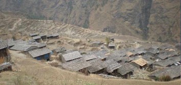
Enter Sama through a yellow kani and pass a gompa (smothered in mani stones) to rows of low stone dwellings with front courtyards.
Only upper Manaslu and the Naike ridge can be seen from the village. Overnight in Sama.
Sama is Nupri’s regional centre. Explore its architecture, customs and home industries. Items made for trade in Tibet include cloth for chubas and woven rugs using local or imported yarn from sheep and goats. Horses, Yak and Dzopkyo (yak-cow cross) herds are bred for trade.
Beyond and above the village is the 700 hundred year old Kargyu Chholing Monastery (or Labrang: Lama’s Place); its architecture is unique and has fine woodwork. The largest of its eight temple buildings is the Pemba Chholing Gompa, with an impressive statue of Guru Rinpoche. It is owned by the Nyingma Buddhist sect whose Lamas are permitted to marry; and live within the complex.(Regrettably much of the Labrang was destroyed in a fire on 18 February 2015.)
A short walk beyond the monastery leads to the Birendra Tal (3 450m, lake) below the Manaslu Glacier. View it from a hilltop or drop to a stony beach which offers striking views of the terrain. 1½hrs
A demanding trail above the far side of the lake (reached from a path at the bridge over the outflow stream) climbs ~1 200m past the glacier’s snout to the Manaslu Base Camp (4 900m), 5-6 hrs
A trek to the Pungyen Nunnery (3 870m), on a ridge above the Pungyen Glacier; offers superb views of the Nadi ice-ridges and Manaslu towering over the gompa.
To reach the gompa, return towards Shyala, passed the school to the turnoff. The trail heads over a ridge above the Numa Khola and drops onto the Pungyen Glacier. Walk to the ridge on which the gompa is built. ~2½hr. The route can be very cold and slippery; take refreshments.
In 1953, much of the gompa was destroyed in an avalanche – and was only recently rebuilt. Blame for the avalanche was apportioned to the first Japanese (unsuccessful) expedition to Manaslu. They were the first to conquer it – in 1956. 5-6hrs Return to Sama for the night.
A pleasant and easy walk today. Pass the lake, the BC trail and several mani walls. Birch and juniper stands cover the hills surrounding Kermo Kharka (pasture) above the now north flowing Budhi Gandaki. Later, a stone wall across the valley separates the Sama and Samdo herds. Further on, a spur rises ahead, between the rivers from the Sonam/Mayol Khola off the Sonam Glacier NE of the trail. Drop to cross the Budhi on a wooden bridge just below their confluence and then the Sonam Khola.
Climb steeply up the spur to a stone arch amid fields. Walk to a white kani at the entrance to Sama: a cold, cluster village against a ridge. Tibetan residents had summer grazing rights to this region, but with the political changes in the late 1950s they fled to Sama and constructed the slate roofed stone dwellings. It is a yak and goat herding post on the trade route to Kyirong; with holding pens amid fields behind the village. This is the last village in Gorkha. The next is Gho in the Manang District (Annapurna region). Several kharkas have teahouses in between.
The vegetation has now changed to alpine low grasses, rhododendron and juniper scrub. After lunch, follow yak tracks up the steep flag bedecked spur behind the village for magnificent 270
views. To the east, along the border, is Sonam Peak (6 335m) with an unusually demarcated glacial moraine. Ahead is the Sama Valley and ranges to the south of Manaslu (hidden by a rocky peak). The view to the west shows tomorrow’s route to Bimthang – and Larkya La along the Larkya Glacier. In the foreground the Syacha Glacier from Manaslu North curls around the foreground peak. Overnight in Samdo.
Drop for the final crossing of the Budhi Gandaki below the former Larkya Bazaar site (3 650m, a popular seasonal trading post before the border was closed). The diminished stream flows from the northern Pana Danda Valley: where a trail leads to two passes to Tibet. Our trail heads west and climbs gently through low scrub above the Syacha Khola and glacier. Its descent from Manaslu North can be seen up that valley.
The trail steadily ascends towards the Larkya Glacier’s snout beyond the hidden Larkya Phedi which gradually comes into view. This seasonal kharka had a kitchen with dining room, 15 small double rooms in two rows and two tunnel tents; each with eight beds plus a third for trekking staff. Better views of the Naike (6 291m) and Larke (6 249m) peaks can be had from higher up the side of the valley. Rest and overnight in Dharamsala.
Larkya La involves an 800m, 3-5 hr ascent (when snow free) and a 1 500m, 3-4 hr descent to Bimthang. It can be bitterly cold if windy; snow and ice will demand more time. Snow poles mark the route along the moraine: it is not difficult or steep, but is long and everywhere rocky underfoot.
A pre-sunrise start begins with a gentle ascent to a ridge before a long ascent to the vast, jumbled moraine field. Ahead, Pawar Peak on the northern border wall of Cheo Himal and Larke Peak on the southern Larkya Himal gradually appear above the moraine. Walk past the first of four small scattered lakes. Finally a steady pull curves towards Larke and the first group of summit flags. The reverse view overlooks the trail, distant Sonam Peak and ranges into Tibet. The Cheo and Larkya Himal ridges block views to the north and south.
Ahead, a moraine ridge, separated from the Larke wall by a parallel gully leads, for ~30 min, to a second set of landmark flags: and the boundary between the Manaslu and Annapurna conservation regions. They also overlook astounding views into a huge semi-circular basin ringed by a mix of magnificent ice peaks and eroding grey rocky walls. Within, three glaciers flow towards the southwest corner.
From north to west, the landmark peaks are Pawar (6 620m), Cheo (6 820m), Himlung (7 126m), Gyaji Kung (7 030m) and Kang Garu (6 981m). Further east Annapurna II (7 937m) rises above lesser peaks.
From the flags, drop steeply off the moraine and then carefully descend the, steep switchback trail, over loose gravels: to grassy Dangboche Kharka (4 450m) below your feet.
Rest frequently to marvel at the results of the valley’s glacial action. The Pawar Himal produced the Salpudanda and Ponkar Glaciers which then merge (trapping the medial Ponkar Tal). The third, Kechakyu Glacier, then merges with the others at the western end of the valley forming the Bimthang Glacier whose outflow swells the Dudh (milk) Khola: forming the border between the Manaslu and Annapurna Himals.
The gradient from Dangboche Kharka is more comfortable. Descend beside the lateral moraines into a narrow valley and a T-junction: north and up to explore the Ponkar Tal (3 960m); south a gentle walk into the lovely Bimthang (plain of sand) Valley – and attractive teahouses ahead. Beyond, the northeast face of the Manaslu – Chuli Ridges rise high above forest. The Kechakyu Himal guards the trail to Ponkar Tal.
Bimthang has become the summer grazing settlement for the Samdo population. It was an important trading post before the closure of the Tibetan border. Tibetan Khampa warriors had a centre here in the 1970s. Overnight in Bimthang.
Walk across the Bimthang Plain; then begin a 1 200m descent to Gho. Cross the stony glacier before climbing its far moraine to enter magnificent pristine oak, rhododendron and pine forests. Views of the Manaslu – Chuli Range continue along the route. Descend along the Dudh Khola’s west bank to Hompuk (3 430m, a rock shelter near a bridge) then attractive Sangura Kharka (3 430m). Drop steeply to cross the Suti Khola to Karche (2 700m) for lunch. Follow the river’s S bend then negotiate a flood related landslide and a steep ridge climb past terraced fields to the charming Gurung village of Gho. Overnight in Gho.
After breakfast, descend through farmlands to the old paved village of Tilje (2 300m). Cross to the river’s east bank and descend rapidly into the Marsyangdi Valley through scrub forest. Return to the west bank before Thonje (1 965m) and then, in Thonje, cross the descending Marsyangdi Khola (from Manang) prior to their confluence. Join the new road from Manang on the Annapurna Circuit. Stop for lunch.
As the Annapurna trail moves further NW behind the Annapurna massif, the landscape becomes drier in the rain shadow of the peaks. Winds also increase from ~10:00 – 16:00 as air is drawn up from the south by rising hot air off the high Tibetan plateau. This frequently affects the Tilicho Trail and Thorung La route and, invariably the Gandaki Valley. High valleys can be very windy and extremely cold. Trekking early minimises the discomfort.
We now follow the Marsyangdi Nadi for six days to its source, the Tilicho Tal, on the North Annapurna Glacier. The valley swings westwards and the trail climbs steep forested ridges, over some landslides, as it ascends the southern slopes of the valley. Good views of the Lamjung Himal, Annapurna II (7 937m), and Annapurna IV gradually rise to the south. They come into full view at the landmark mani wall before Chame: the Manang District headquarters. Overnight in Chame.
A steep trail on the north bank, through a dense fir and pine forest, passes the gigantic curved, ice-carved rock face above Bhratang (2 950m). It rises 1 500m above the river: and takes an hour to pass. Later, walk along an impressive ledge hewn from a cliff face before the trail re-crosses to the southern bank of the river and ascends, opposite the wall, into the U-shaped upper Manang Valley between two snow peaks. The views become more exciting as you approach the split-village of Pisang. Overnight in Lower Pisang.
Two trails lead to Manang. The lower route, follows the river to Mungji (3 500m) where it meets the high route and continues to Braga and Manang.
The challenging upper route presents some of the best scenery on the trek. Climb to Upper Pisang (3 310m) then walk through the dry Nyesyang region to Ghyaru (3 670m): a cluster-village of houses surrounded by fields of barley, buckwheat, beans and potatoes: crops that ripen in a short growing season. Follow a high traverse with great views of the whole valley to Ngawal: a village with ancient juniper trees and a neat gompa. Overnight in cold Ngawal.
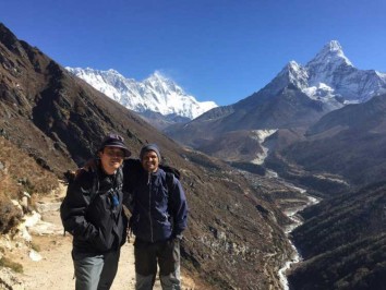
Descend gradually to Mungji (3 500m), with a nunnery above the village. Next, is picturesque Braga (3 470m): with clustered houses stacked one above the other up a craggy slope. An impressive Gompa sits at the top. This is the oldest and best endowed gompa in the region. Manang is a short walk from Braga. Rest and explore the village. Overnight in Manang.
Today is a scheduled acclimatization day. Walk to either Gangapurna Lake or the Bocho Gompa. The Himalayan Rescue Association office has informative information on the symptoms of Altitude Mountain Sickness. Return to your teahouse for the night.
The trail drops below Manang and heads west along the north bank of the Marsyangdi Nadi. After crossing the Thorung Khola tributary, the trail climbs to a ridge and old fort ruins: with commanding views back down the valley - as far as distant Manaslu. Continue, through stands of blue pine and then the wheat fields below Khangsar. Stop for lunch in the village square.
The trail then climbs, passed the village gompa and school and continues through rich grazing juniper and seabuckthorn scrub to Thare Gompa (3 930m). It soon joins a trail from the lake to Yak Kharka shortly before Shree Kharka. Overnight in Shree Kharka.
Much of today’s trail involves traversing barren steep, exposed and unstable scree slopes truncated in places by weathered rocky spurs. From the hotel, climb up a side valley to a trail junction then head left on the shorter route to BC. Drop to cross a tributary then climb through several kharkas to a ridge. After crossing a second stream the scree walk begins. Take care and watch for descending debris: the path, over gravels and sand, rises gently; towards the BC it becomes rockier underfoot and in places steep as it climbs over several of the rocky spurs. BC is set in a shallow valley, partially protected from the winds. Tilicho Peak is 7 134m. Overnight in Tilicho BC.
Ascend, for an hour up a side valley on a firm trail before climbing onto a gravel moraine and continuing upwards for another hour to 4 700m with increasing views of Tarke Kang, Gangapurna and Khangsar Kang (its black slopes too steep and smooth to hold snow) plus the Manang Valley behind. Steep gravel zigzags complete the climb to a cairn at 5 010m. This is followed by ~¾ hr of gentle walking to flags and the first views overlooking the lake at 5 005m. The sandy edge of the lake is ~90m below and easily reached. The lake is 4km long, 1,2km wide and ~85m deep: and is not the highest of lakes. (There are 15 over 5 555m/18 200ft which is Nepal’s highest: Panch Pokhari below Baruntse in the Everest Region.)
Walk back, for 1½ hr to Tilicho BC, for lunch. The return trek to Khangsar will take 3½ -4 hrs. Overnight in Khangsar.
An easier day. Climb above the village to meet the Tilicho Tal – Yak Kharka trail. Ascend before dropping to cross the Thorung Khola over a wooden bridge. Then climb to meet the trail from Manang below Ghyanchang (which is above the trail. After crossing the Ghyanchang Khola the trail rises gently through kharkas of grazing horses and yaks. Later, a wooden bridge heads towards an ancient mani wall and the small village of Yak Kharka for lunch and great views. Overnight in Yak Kharka.
A short day’s slow, steady 500m climb leads to the seasonal outpost before the pass. The path snakes through desolate high scenery: scrub vegetation gradually giving way to rock, scree and an exposed path across a landslide before reaching the trekker-lodge at Thorung Phedi (foot of the hill). There is a single teahouse with a warm cosy dining room and beds for some 150 trekkers. It closes for the winter months. Overnight in Thorung Phedi.
Further up the “hill” lodge staff man a small stone teahouse on a cold exposed ridge: known as High Camp. Rather stay at Thorung Phedi than head for this elevation: just for a shorter summit day.
A pre-dawn start is wise for this long arduous day. There is a 900m/3 000ft ascent before a 1 600m/5 250ft descent. From the teahouse the path climbs steeply up the valley: leading to a stiffer ascent up an ancient moraine. After that, it ascends more gently. Thorung La is a flag bedecked col between Thorung Peak (6 211m/20 378ft) and Yakwakang’s (6 482m/15 434ft) stupendous cliffs.
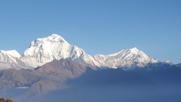
Views back to the east are snowy. Ahead and far below is the brown desolate scenery of the rain-parched Kali Gandaki-Mustang Valley. On the opposite side of the valley, the huge Dhaulagiri range rises to the southwest. Ahead and to the north, the mountains of Dolpo stretch to the horizon: these are an extension of the Tibetan uplands to the north.
After photos and a rest, begin the ~4hr descent to Muktinath. Tread with care as the path drops steeply over loose gravel. Later, it becomes rockier and easier to walk on. The captivating scenery and chance to “sleep low” should spur you on.
Eventually, the important Hindu and Buddhist pilgrimage site of Muktinath will come into view. This oasis of springs is surrounded by a lengthy wall and is bedecked by thousands of prayer flags. There is a small Vishnu temple and smaller Buddhist Shrine: testament to Nepal’s religious harmony. The Tibetan name for this oasis is Chu Mig Tsa Gye (108 springs).
The dusty village of Ranipauwa (3 710m, and traffic) is a 10 minute walk beyond the Shrine. The region is collectively known as Muktinath. Overnight in Ranipauwa.
A rutted road has been built, mostly along the trekking trails, from the lowlands to Muktinath. A recent Chinese road from Tibet through Upper Mustang meets this road below Kagbeni (2 840m: consider a detour to this fascinating ‘first village’ into Mustang.) From ~10:00 to 16:00, daily winds blow in dust from the lowlands and now the gravel road makes trekking particularly unpleasant.
Jeep transport has become preferable through this rugged scenery; and returning vegetation. Jeeps are used for the drive to Jomsom (2 760m, administrative centre of the Lower Mustang region). Change to a second jeep for Tatopani (hot springs). From there we leave the road and Buddhist culture – and trek into lush forest once more. Overnight in Tatopani.
The trail enters the Ghar Khola Valley which swings south east towards the front of the Annapurna Range. Most of the trail is through protected rhododendron, oak, birch and magnolia forests; rich in wild life. Ghara (1 780m), Phalate (2 390m) and Chitre (2 420m) are agricultural villages on high ridges: with views of Dhaulagiri and the Annapurnas. The large tourist village of Ghorepani is below Poon Hill. Overnight in Ghorepani.
An early, ¾ hr, steep trek leads to Poon Hill’s grassy knoll. This landmark viewpoint offers unobstructed vistas of the high Himalaya from Dhaulagiri I (8 172m) and Upper Dolpo in the west, across the Annapurnas (Annapurna I, 8 019m), to Machhapuchhare (6 997m, Fish Tail) and east to Manaslu (8 156m). Behind: an ocean of Sal forests stretch to lowland India.
After breakfast, trek east through pine and rhododendron forest, over numerous ridges, to Tadapani: with occasional flat sections and wonderful views of the snow peaks to the north from high ground. Overnight in Tadapani.
Today offers a short, downhill trek through farmland and forest with occasional peak views to Ghandruk: a modern Gurung village. Afternoon free: to explore the area; and village museums. Overnight in Ghandruk.
The trail drops down stone staircases to the Modi Khola: from Annapurna’s South Glacier in the breathtaking Annapurna Sanctuary. Cross the river and walk up to Landruk (1 620m) then through scrub bush to Tolka (1 790m). A further ~2 hr trek, through lovely forest ascends to the ridge village of Deorali (2 150m). Views of Pokhara and Lake Phewa are Behind are the last views of Dhaulagiri, Annapurna wall. The trail then drops down a broad red-earth track (that is lethal when wet) to Pothana. Overnight in Pothana.
An easy descent leads to the agricultural village of Dhampus (1 700m) then smaller hamlets with rice paddies to Dhampus Phedi on the Pokhara – Baglung highway: for the short drive to Pokhara and your hotel. Afternoon free: to explore the lake and waterfront; or visit the Mountain Museum. Overnight in Pokhara.
After breakfast, drive to the nearby airport and fly back to Kathmandu along the Himalayan Range. Transfer to your hotel. Afternoon free.
Transfer to Tribhuvan International Airport for your flight to your next destination.

We spent amazing 30 days in mountains with Landmark Discovery Treks. They prepared the whole trek according to our requirements. We wanted to start in Tsum Valley, continue to Manaslu Circuit and after that continue to Annapurna Circuit and Tilicho Lake. Prem (the owner) prepared for us the itinerary and he was very quick with his answers and always helpful. Thank you Prem for your perfect coordination.
It was long 30 days trek and we were only 2 persons so we were a little bit nervous in the beginning. But everything was absolutely without problems. We had excellent guide Ganesh, who was always helpfull, friendly and it was a lot of fun with him. The same was our porter Prem. Thank you guys, you were both perfect!
Our guide always chose very good and clean hotel which provided very good food. We had privat room for two persons everywhere and sometimes, when there was the possibility, we had a privatbathroom. We had breakfast, lunch and dinner included and we also got some fruit (there are very good sweet apples in Nepal :)), biscuits, chocolate bars... it was wery nice from them.
Our guide took care of us all the time. Sometimes there were some dangerous areas with falling rocks and stones, frozen or narrow path, but we were always safe. The price was also very reasonable.
We can highly recomend Landmark Discovery Treks for everyone who wants to experience so amazing trek in Himalaya mountains as we did. Thank you!!!
Show less
25th Apr, 2022