Main Navigation

Bhandar - Everest Trek is a newly discovered trail perfect for those seeking an offbeat experience in remote and intact part of Everest region of Nepal.
Buddhist Sherpas, who migrated from Tibet some five centuries ago, settled in the Solu, Khumbu and Helambu Districts. This trek follows the old and early explorer’s route (followed by Tenzing Norgay and Sir Edmund Hillary in 1953 on the first successful conquest of Everest) into the Solu-Khumbu trekking region: still used by countless porters and pack animals.
From Kathmandu, the road follows the Kodari Highway towards Tibet to Khadichaur before turning east and snaking along a rough secondary road through the middle hills to Bhandar: where the trek now begins.
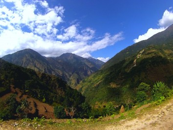
In the first week, the trail explores beautifully terraced farmlands, forests and classic middle-hill countryside. It offers simple amenities and ample time to acclimatize (the trail undulating from 1 500m - >3 000m): while encountering the culture, customs and lifestyle of the friendly and hospitable Hindu and Buddhist communities.
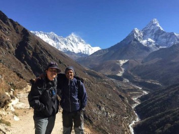
Rest days are taken at Junbesi (visit the Thubten Chholing Monastery), Namche Bazaar (business hub of the Khumbu District) and Dingboche (walk to the Nangkartshang Gompa Ridge to view the glacier fields below Nuptse, Ama Dablam, and Makalu to the east).
Beyond Namche, the trail rises more quickly and night temperatures drop. From Dingboche the pace slows towards the last village of Gorak Shep; and the trail along the Khumbu Glacier to Base Camp, opposite the ice fall.
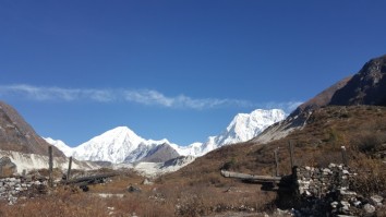
A pre-sunrise climb from your teahouse offers glorious views that include Cho Oyu in the west, Everest, the South Col, Nuptse and Lhotse. Lower Pumori, Lingtren and Khumbutse surround the Base Camp.
The easier four day downward trek uses an alternative route and overnights in different villages. With a flight back to Kathmandu from Lukla, the Bhandar - Everest trek comes to an end.
Everest Budget Trek is another trek for the trekking and know about Everest Region as well as for the experience of Khumjung valley's people and their lifestyles, beliefs, skills and warmth.
The best times of the year to perform the Bhandar - Everest Trek are during spring (March to May) and autumn (last week in September to mid-December) seasons. During these periods, the weather remains stable and the mountain views are good leading to the best experience. In monsoon, the weather can be unpredictable and the rain can make the trails slippery and perilous. While it is possible to trek in winter, heavy snowfall and harsh temperatures can sometimes make the trek quite difficult.
This 22 Day Bhandar - Everest Trek is a lengthy and fairly strenuous trek that takes you up to altitudes of 5554m (Kalapattar). You will be trekking on hilly trails and semi mountainous terrain for most of the trek. While previous trekking experience is not a necessity, it will certainly make the trek easier. Good physical fitness and stamina is recommended along with ample time and rest days for acclimatization.
NRS. 1000 ($10) for organized trekkers
NRS. 2000 ($20) for independent trekkers
NRS. 3000 ($30) per person
Khumbuu Pasang Lhamu Rural Municipality
NRS. 2000 ($ 16) Per Person
Day 01:Arrival Kathmandu Tribhuvan Airport (1 300m/4 260ft). We will meet and transfer you to your hotel.
Day 02: In the City Kathmandu Valley Sightseeing Tour OR A day at leisure. Trek preparation.
Day 03:Kathmandu – Bhandar (2 200m/7 220ft), 10-12 hrs drive
Day 04:Bhandar – Sete (2 520m/8 270ft), 5-6 hrs
Day 05:Sete – Junbesi (2 680m/8 850ft), 6-7 hrs
Day 06:Junbesi: Acclimatisation and exploration day.
Day 07:Junbesi – Nunthala (2 220m/7 820ft), 5-6 hrs
Day 08:Nunthala – Bupsa (2 360m/7 740ft), 5-6 hrs
Day 09:Bupsa – Ghat (2 590m/8 500ft), 5-6 hrs
Day 10:Ghat – Namche Bazaar (3 440m/11 290ft), 5-6 hrs
Day 11:Namche Bazaar: Acclimatization and exploration day.
Day 12:Namche Bazaar – Tengboche (3 870m/12 700ft), 5-6 hrs
Day 13:Tengboche – Dingboche (4 360m/14 300ft), 5- 6 hrs
Day 14:Dingboche: Acclimatization and exploration day.
Day 15:Dingboche – Lobuche (4 940/16 210ft), 4-5 hrs
Day 16:Lobuche – Gorak Shep (5 160m/16 930ft) – Everest Base Camp (5 360m/17,590ft) – Gorak Shep, 7-8 hrs
Day 17:Gorak Shep – Kala Patthar (5 550m/18 210ft) – Pheriche (4 280m/14 040ft), 7-8 hrs
Day 18:Pheriche – Phortse (3 810m/12 500ft), 4-5 hrs
Day 19:Phortse – Monjo (2 800m/9 450ft), 5-6 hrs
Day 20:Monjo – Lukla (2 640m/8 660ft), 5-6 hrs
Day 21:Lukla – Kathmandu (1 300m/4 260ft), 35 min flight. Return to your hotel. Rest of day free.
Day 22:Final Departure: Transfer to Tribhuvan International Airport for your flight to your onward destination.
NB: Cloud and turbulent weather along the mountain ranges is common and may lead to internal mountain flight delays or cancellations. We suggest you add at least one extra day after your trek before flying out of Nepal.
After completing passport, immigration and visa requirements, we will meet you outside the terminal building (look for your name board) and transfer you to your hotel: afternoon free. Evening: a welcome dinner, introduction to your guide and a briefing on the trek with a check on necessities. Overnight at hotel.
Take a day tour to five of the Kathmandu Valley’s cultural world heritage sites: Swayambhunath, the famed “monkey temple;” the city’s historical Durbar Square with ancient temples, unique art, architecture, and the chance to see the Kumari (living goddess); Patan’s Durbar Square; the Hindu temple Pashupatinath and Bouddhanath, the world’s largest stupa.
A car and driver will take you to each site-entrance and wait for you. (Entry tickets and lunch are not included.)
Bhandar is reached by a circuitous but scenic bus drive through mountain villages with tantalising views of the High Himalaya to the north. First, a 3 hr drive NE of Kathmandu to the Bhote Koshi Valley and Khadichaur on the Kodari Highway to Tibet. A secondary road then heads east, snaking slowly through the hills to Charikot, Jiri Bazaar (start of early Everest expeditions) and then on a recent extension of the road, to Bhandar. Overnight in Bhandar
From the village follow a new trail that roughly contours along the northern side of the valley; before dropping to a suspension bridge over the Bhandar Khola. Follow the southern bank to Kinja (1 570m).
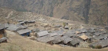
A steep zigzag path ascends to the Lamjura Bhanjyang (ridge) and Chimbu (2 170m). Beyond the village a fork to the right heads up through farmland to the friendly village of Sete: in the Sherpa Solu District. Overnight in Sete.
Trek through birch, magnolia, maple and rhododendron forests, alive with birds. Long Himalayan ranges are visible from deforested hilltops; reduced to inadequate pastures. A long steep haul leads to the Lamjura La (3 530m); which can be cold and shrouded in mist by midday. A steep 400m descent, through stands of hemlock and fir, ends at a river and wooden teahouse. The trail then climbs again, past a painted mani wall, near the top of the rise. A ridge climb follows to a viewpoint overlooking Junbesi and surrounds. Overnight in Junbesi.
This is an attractive bazaar town offering interesting walks to several Buddhist monasteries on the surrounding slopes. The Number (6 960m, or Shorong Yul Lha – god of Solu) landmark dominates the valley to the north. Alongside the yellow-topped village Stupa is the largest of the 30 ‘Hilary Schools’ built by Everest’s conqueror. Explore the Tashi Thongmon Gompa, in the village centre; founded in the 16th C. Also visit the Thubten Chholing Monastery: founded by Trulsuk Rinpoche with a group of monks and nuns who fled the Rongbuk Monastery (on the N Everest route in Tibet) after 1959. Return to your teahouse for the night.
Drop to cross the Junbesi Khola then take the left fork that winds steeply up through pines and kharkas to a ridge and the village of Phurteng (2 640m). To the north are the first views of Everest behind Thamserku, Kangtega, Mera Peak and numerous other 6 000m summits.
The trail now heads north, descending to Salung (2 860m) and on to cross the Dudh Kund Khola (from the sacred lake to the north) before climbing through fruit orchards to Ringmo (2 720m); built around a stupa. Climb steeply through pine and rhododendron forest to Pangoma and on up the Trakshindu La (3 071m), landmarked by a beehive stupa surrounding several dwellings. Visit the impressive Trakshindu Gompa: a renowned example of monastic Sherpa architecture. Descend through forest and fields to Timbu (2 590m) and on down to cross a suspension bridge shortly before the village of Nunthala. Overnight in Nunthala.
Descend through forest and farmland to Phuleli then down through scrub forest and ferns to the Dudh Koshi (1 240m, Milk River, flowing south from Nepal’s longest, Ngozumpa Glacier). Cross the long suspension bridge and ascend through terraced fields to Jubing (2 680m, a Hindu Rais settlement). Then climb to a ridge and the village of Khari Khola (2 010m) overlooking the river valley. Bupsa can be seen on the opposite ridge. To reach it, descend to Khari Khola (2 840m), cross the river near water-driven mills, then climb steeply through terraced fields to the colourful village. Overnight in Bupsa.
Today’s trail crosses from the Solu to the Khumbu Sherpa District. From Bupsa the track climbs gently through dense monkey and bird filled oak forest to Kharte (2 680m). It then ascends the Khari La (2 840m), for 1½hrs: with panoramic views over the valley – including landmark Khumbila (the sacred Sherpa mountain above Namche Bazaar) and further north Cho Oyu (8 201m – source of the Ngozumpa Glacier). Drop through forest, into a canyon to cross the Paiya Khola then climb, for an hour to the Paiya La (2 805m) before descending gently to Surkhe (2 290m). (Beyond the village a stone stairway head up to Lukla.) Follow the lower path which rises through small villages to meet the Lukla – Namche Bazaar trail at Cheplung (2 700m). Continue, above the river, through Thado Kosi to the comfortable village of Ghat. Overnight in Ghat.
Walk through pine forests along the Dudh Koshi, crossing tributaries, to the Sherpa villages of Benkar (2 710m), Chumoa (2 820m), Monjo (2 840m) and Jorsale (2 830m). This is the gateway and permit checkpoint to the Sagarmatha National Park. Thamserku (6 618m) glistens east of the village. Follow the river to its confluence with the Bhote Koshi: the major rivers draining the Khumbu District. Climb steadily, crossing the high Tenzing-Hilary Bridge, to the first glimpses of Everest and the Nuptse-Lhotse ridge. A further 3 hr forested climb leads to the region’s administrative and trade centre at Namche Bazaar. Overnight in Namche Bazaar.
This is a scheduled acclimatization day (over 3 000m). Acute Mountain Sickness (AMS) experts recommend at least a 24 hr rest period. Keep active: climb high and sleep low is the acclimatisation advice.
Only Namche offers ATMs, cyber cafés, restaurants and bakeries, plus a colourful market each Friday evening and Saturday morning. The Sagarmatha (Everest) National Park Visitor’s Centre has informative displays on Sherpa culture, local flora and fauna.
The village of Khumjung (3 780m) will present a more traditional view of Sherpa life than Namche. Spend a morning walking up to the village. A circular trail is possible. At very least, visit the closer Everest View Hotel (3 880m).
A more adventurous five hour trek west to Thame (3 820m): below the impressive Kongde Ri Ridge (6 187m), offers panoramic Himalayan landscapes not visible from the Gokyo or Everest trails.
From the top of Namche, the trail contours around a hill to Sanasa (3 600m); and a trail fork: NW to Gokyo, NE to Everest. Look for Himalayan tahrs on high ground, shy spotted deer, and birds – including the colourful (male) national bird: the Danphe pheasant. Descend to water driven prayer wheels at Phunki Thenga (3 250m, lowest point north of Namche). Cross the Dudh Koshi near its confluence with the Imja Khola and climb steeply for 2 hrs up the Imja Khola Valley through rhododendron and dwarf conifers to the hilltop village of Tengboche.
Good views from the village include the Everest group. There is an important monastery that is well worth visiting. At October’s full moon the colourful, Mani Rimdu festival is held; with Tibetan Opera and masked dancing. Overnight in Tengboche.
Descend to the scattered stone village of Debuche (3 820m): with a nunnery. Cross the Imja Khola to the north and gradually ascend to Pangboche (3 860m) with rear views of towering Ama Dablam (6 856m). The trail follows the river to its confluence with the Lobuche Khola and continues to Dingboche: the last year-round settlement in the region. Walled terraced fields protect barley, buckwheat and potatoes from icy winds and marauding animals during the short growing season at this altitude. Overnight in Dingboche.
To acclimatise: head north to the Nangkartshang Gompa ridge (4 800m) for views of the Nuptse Glacier, Chhukhung Ri (4 230m, which masks Lhotse’s glaciers) and Imja Tse (6 189m). Further east, along the Mahalangur Himal Ridge, is imposing Makalu (8 463m). Towards the south is, Amphu Lapcha’s fluted ridge (5 845m) and the unusual view of Ama Dablam’s north face and glaciers. Return to the teahouse in Dingboche.
Ascend slowly to a ridge and the hamlet of Duse (4 500m) with western views of Taboche and Cholatse. Continue through kharkas to Duglha (4 620m). Then ascend the Khumbu Glacier’s huge stony terminal moraine (1 hr). Landmark balanced-stone memorials to lost climbers have been placed along its rim. To the north, border peaks along the Mahalangur Himal include Khumbutse, Lingtren, and Pumori. Everest is hidden by the imposing Nuptse-Lhotse wall. Continue to and overnight in Lobuche.
A desolate trail along the moraine heads for the last, seasonal, village of Gorak Shep below Pumori. After an early lunch, trek to cold EBC: positioned on the Khumbu Glacier opposite the dreaded icefall – the most nerve wracking section of an Everest ascent.
During the April-May ascent season, porters scurry in and out with supplies like an army of ants and the site is a riot of colourful tents perched on the dirty ice. Out of season it is bleak and silent, bar birds wind and avalanches. Everest and the Cwm are hidden behind the West Ridge. Walk back to Gorak Shep for the night.
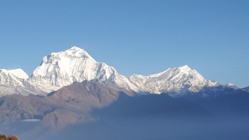
From the village, a pre-dawn climb (2-3 hrs) up Kala Patthar, offers sunrise over: Everest (8 848m/29 028ft), Lhotse (8 516m), Nuptse (7 861m) and Changtse (7 550m, north of the Rongbuk Glacier). Then Pumori (7 145m), Lingtren (6 697m) and Khumbutse (6 623m) amidst countless other peaks that crowd your horizon. Cho Oyo (8 201m) can be seen further to the west:
After breakfast: retrace your steps to Lobuche (4 940m) and the landmark memorials on the glacier’s snout. Descend the moraine and follow the western trail to lower and warmer Pheriche. Overnight in Pheriche.
Climb gently up an alternative trail to Pangboche (4 280m): and the Khumbu’s oldest monastery (17th C). A quieter trail north of the river passes through ‘game country’ (including musk deer) to Phortse, on the Gokyo Lakes trail. Overnight in Phortse.
Trek south through Mong La (3 975m) to Sanasa (3 600m). Join the broad main trail and walk back to Namche (3 440m). Then drop into the greener valley and Jorsale (2 830m). Exit the National Park and walk down to Monjo; at a comfortable altitude. Overnight in Monjo.
Follow the Dudh Koshi, through farming villages to Phakding (2 610m). Cross the suspension bridge at Thado Koshi and walk to Cheplung (2 700m). Descend and then climb steeply back to Lukla: where your porters will take their leave. Overnight in Lukla.
After an early breakfast, take the return flight to Kathmandu. Transfer to your hotel. Rest of day free.
Transfer to Tribhuvan International Airport for your flight to your next destination.
NB: Cloud and turbulent weather along the mountain ranges is common and may lead to internal mountain flight delays or cancellations. We suggest you allow at least one extra day after your trek before flying out of Nepal.