Main Navigation

Our 14 day fly in walk out trek to the sacred site of Muktinath in the Annapurna region also introduces you to rural Nepal and explores the Kali Gandaki River system that cut the world’s deepest canyon between the 8 000m Dhaulagiri and Annapurna ranges as the Himalayas rose. In summer dry air over the northern Tibetan plains rises, drawing in cooler air from India and Nepal. This causes the winds (lomar) that blow up the Valley from ~10:00 to 16:00 hours daily. Thus, with the completion of the dusty dirt road to Tibet, jeep tours gradually replaced trekking in the valley.
This trek offers alternative routes, where possible, to minimise the time spent “on the road.”
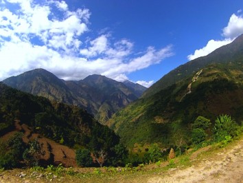
From Kathmandu drive west through scenic Middle Hill forests and farmland, south of the high peaks, to the holiday playground of Pokhara on Phewa Lake. Explore the lake and city.
Fly to Jomsom, capital of Lower Mustang, and trek to Muktinath via Kagbeni, the southernmost village of Upper Mustang. This region of hardy people live in a magnificent yet barren landscape (in the rain shadow of the Annapurnas): and long controlled trade between Tibet and India. They rely on irrigation systems fed by snow melt for water and crops. The town is well worth exploring.
A new tarred road leads to Muktinath (3 800m); which is less windy. Revered as a ‘place of liberation’, Muktinath is dedicated to the godhead of the Hindu pantheon, Lord Vishnu. The site is holy to Hindus and Buddhists and contains several temples. It is auspicious for the rare meeting of earth, fire and water. A constant flame of subterranean gas burns next to a small perpetual spring (now protected within a temple). A trail drops past the complex from Thorong La and Manang on the popular Annapurna circuit.
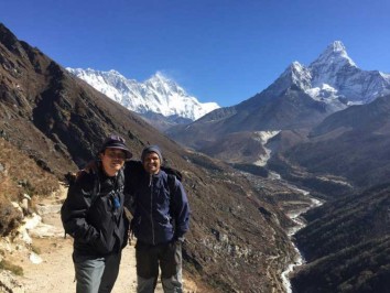
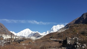
Return to Jomsom and walk down the valley to Ghasa: last of the Tibetan villages, some with great architecture. Enter the Hindu region and continue to Tatopani (hot springs) before leaving the river and road to walk through pristine indigenous forests of oak and rhododendron to Ghorepani. A pre-sunrise walk to Poon Hill (3 210m) offers a 60km panoramic view of the high Himalaya, including three 8 000m peaks. Return to Pokhara then drive or fly to Kathmandu.
If you wish to experience more of the immensely beautiful Annapurna region, take a look at our rewarding Annapurna Base Camp, Annapurna Circuit Trek or Annapurna Panorama / Poonhill Sunrise packages!
The best times of the year to perform the Annapurna Muktinath Fly in – Walk out Trek are during spring (March to May) and autumn (last week in September to mid-December) seasons. During these periods, the weather remains stable and the mountain views are good leading to the best experience. In monsoon, the weather can be unpredictable and the rain can make the trails slippery and perilous while the temperatures might be harsh in winter.
This 14 Days Annapurna Muktinath Fly in – Walk out Trek is a moderate difficulty trek that takes you up to altitudes of 3800m (Muktinath). You will be trekking for 5-6 hours on average every day, over hilly and barren terrain, for most of the trek. Prior trekking experience is not a necessity for this trek. While the trails require no more than minimal fitness and stamina, being fit will certainly make the trek easier.
NB: Flying to Jomsom (2 760m) and then walking up to 2 840m at Kagbeni and the following day to Ranipauwa at 3 700m is demanding. Trekkers need to be fit to minimise the risk of altitude problems.
Day 01: Arrival: Kathmandu Tribhuvan International Airport (1 300m/4 260ft). We will meet and transfer
you to your hotel.
Day 02: A Day in the City: Kathmandu Valley Sightseeing OR A Day at Leisure
Day 03: Kathmandu – Pokhara (880m/2 900ft), 6-7 hrs drive or 30min flight
Day 04: Pokhara – Jomsom (2 760m/9 055ft) – Kagbeni (2 840m/9 320ft), 15 min flight, 3-4 hrs trek
Day 05: Kagbeni – Ranipauwa (3 700m/12 140ft), 5-6 hours
Day 06: Ranipauwa – Muktinath visit (3 800m/12 470ft) – Lubra (2 790m/9 150ft), 3-4 hrs
Day 07: Lubra – Marpha (2 680m/8 800ft), 4-5 hrs
Day 08: Marpha – Kalopani (2 530m/8 300ft), 5-6 hrs
Day 09: Kalopani – Tatopani (1 190m/3 900ft), 6-7 hrs
Day 10: Tatopani – Ghorepani (2 870m/9 420ft), 7-8 hrs
Day 11: Ghorepani – Poon Hill (3 210m) – Tikhedhunga (1 540m/5 050ft), 5-6 hrs
Day 12: Tikhedhunga – Nayapul (1 070m) – Pokhara (880m/2 900ft), 3-4 hrs
Day 13: Pokhara – Kathmandu by bus or plane (1300m/4 260ft), 6-7 hrs drive or 30min flight
Day 14: Final Departure: Transfer to Tribhuvan International Airport for your flight to your onward
destination.
After completing passport, immigration and visa requirements, we will meet you outside the terminal building (look for your name board) and transfer you to your hotel: afternoon free. Evening: a welcome dinner, introduction to your guide and a briefing on the trek with a check on necessities. Overnight at hotel.
Take a day tour to five of the Kathmandu Valley’s cultural world heritage sites: Swayambhunath, known as the monkey temple; the city’s historical Durbar Square with ancient temples, unique art, architecture, and the chance to see the Kumari (living goddess); Patan’s Durbar Square; the Hindu temple Pashupatinath and the world’s largest stupa, Bouddhanath,
A car and driver will take you to each site-entrance and wait for you. (Entry tickets and lunch are not included.)
After breakfast, drive to Pokhara along the Prithvi Raimarg which offers fascinating glimpses of rural Nepal’s Middle Hill scenery and major rivers such as the Trisuli Nadi, which rises in Tibet north east of Kathmandu.
Transfer to your hotel. An afternoon City Tour includes: Devi’s waterfall and Shiva’s Cave. Enjoy an evening cruise on tranquil Lake Phewa before dinner. If time, visit the Mountain Museum. Overnight in Pokhara.
After breakfast, board an early morning flight, with good snow-peak views, to Jomsom, the drab, windy administrative centre of the lower Mustang region in the Kali Gandaki Gorge. Their Eco Museum includes exhibits of herbal medicine: the ancient and remarkable backbone of healthcare for Nepal’s high region scattered communities.
Headwaters of the ancient Kali Gandaki Nadi are the Mustang -Nhubine Himal glaciers in the northwest corner of Mustang: as the Himalayas rose, the river continued to cut its path to the Ganges between the Dhaulagiri and Annapurna ranges; creating the world’s deepest gorge. Hot air on the high, dry Tibetan plains to the north rises daily, drawing cooler air from the lowlands up the gorge between ~11:00 and 16:00 – creating unpleasant dust storms (lomar).
North of Jomsom, the valley broadens and the river meanders across its bed: rising only 200m to Kagbeni. The road follows the eastern bank up the ancient India-Tibet salt route to Eklai Bhatti and Kagbeni (confluence of the rivers) – where the significant Jhong Khola tributary that drains the ranges above Muktinath joins the Kali Gandaki.
Vegetation is reduced to juniper and low shrubs that can survive the harsh dry winters - with Kobang roughly the lower limit.
Kagbeni is the southernmost village of Upper Mustang that stretches to the Tibetan border. Lower Mustang reaches down to Ghasa (last of the Tibetan villages).
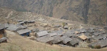
The town is ancient and its architecture reflects the harsh conditions of a region that lies in the north-western rain shadow of the Annapurnas. Its verdant orchards and fields are only possible with irrigation from snow-melt river water. The residents are Baragaunle; people of the 12 villages in the southern region of Upper Mustang. Their beliefs are a mix of ancient Bön animistic rituals and a transformed Tibetan Buddhism; common throughout Upper Mustang and Dolpo. Explore the town and visit the old gompa. Nilgiri stands proud south of the town.
To the north, the scenery changes to rugged eroded brown cliffs and high plains were people eke out a living along snow-melt courses from which they irrigate crops and graze livestock. Dwellings are clustered to minimise the effects of the harsh climate. Overnight in Kagbeni.
A newly tarred road heads east up to the Hindu and Buddhist pilgrimage site at Muktinath. [And the brutal 1 700m climb to Thorung La (5 416m) then down to Manang: not to be considered from this side]. Follow an old trail up the Jhong Khola valley then join the road to Jhong for lunch. Explore the town, then continue to Ranipauwa. Overnight in Ranipauwa.
The holy site of Muktinath (15 min beyond Ranipauwa) draws Hindu and Buddhist pilgrims from afar. For Hindus it is the next most auspicious place after Pashupatinath in Kathmandu. The site is revered for the rare meeting of earth, fire and water. A constant flame of naturally burning subterranean gas burns next to a small spring (now housed within a tiny temple).
Nearby, natural spring water fills two pools that stand in front of a Hindu temple around which are 108 brass waterspouts in the shape of cows’ heads. Further temples stand within the large walled and treed enclosure (including Banyans, Peepul and Poplar trees): all beneath countless strings of prayer flags. [The number 108 is considered sacred in the Dharmic Religions that originated in the Indian subcontinent; including Hinduism, Buddhism and Jainism.] The Tibetan name for this oasis is Chu Mig Tsa Gye (108 springs).
Return to Ranipauwa. Head southwest along the road, through poplar, fruit and grain meadows to Jharkot (fortress, 3 500m): on a rocky knoll overlooking the valley. It houses a Tibetan medical school and large gompa and is worth exploring. After an early lunch, descend into the barren Panda Khola Valley with low scrub bush on an easy (cycle) trail to Dhangladanda. Beyond, the trail steepens, then crosses a long suspension bridge to Lubra on the southern bank. Homes are clustered on steep slopes above the river, surrounded by neatly built and verdant terraces. Lubra has two monasteries and the only Bön School in the region. Overnight in Lubra at a more comfortable altitude.
Cross the river, on a second bridge, and descend to its confluence with the Kali Gandaki south of Eklai Bhatti. Return on the up-route to Jomsom. From Jomsom to Marpha, the river drops a mere 270m meandering across its broad stony bed which narrows towards Marpha.
Marpha is a Thakali village, away from the road, with paved walkways, underground drainage and whitewashed houses with firewood stacked on flat roofs. The 200 year old ‘Potala-style’ Samtenling Gompa overlooks the town. Power is provided by a nearby 260KW hydroelectric plant.
A horticultural research station was set up in the 1960s. New strains of apple, peach, plum, apricot and walnut varieties have been developed that thrive in the high, dry atmosphere of the region. Solar power produces dried fruits. Overnight in Marpha.
Between Marpha and Tukuche (2 580m) the valley narrows. Birch, pine and conifers gradually replace the alpine growth. The road continues on the west bank. A dust-free trail crosses the river and climbs to Chhairo and Chimang with great views of Dhaulagiri and views over the towns to the west. Continue to Kokothanti and Titigaon, beyond which the trail descends to cross the river above Kalopani.
OR follow the road to explore the villages.
Tukuche was an important trading post on the India – Tibet trade route with incoming salt, wool and turquoise being exchanged for grain, rice, cloth, cigarettes and European goods. [By the 1950s, the availability of Indian salt with iodine (that prevents goitres) plus the Chinese thrust into Tibet reduced trade.] The town has many fine buildings and boasts a >200 year old family distillery – producing apple, apricot and orange brandies.
Larjung and its satellite villages are worth exploring. Ancient Buddhist retreat caves dot the cliffs, a nunnery overlooks the river and there is a Bön monastery nearby. From Larjung southwards the pines gradually give way to denser indigenous forests.
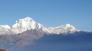
Kalopani has a museum worth visiting. Tackle the ½ hour hike up to Dhulu Danda for great views that include Annapurna I, the three Nilgiri peaks, Tukuche and Dhaulagiri I. Overnight in Kalopani.
Start early for a long day’s walk. Ghasa marks the southern boundary of the Buddhist Thakali people’s Kabre Dada district. Chortens mark the exit to the village. To the south, forests gradually change from birch and pine to subtropical forests.
Before reaching Kabre, the river channel is forced to narrow, causing water to race, noisily, through a hard-rocky defile. At Rukse Chhahara there is an impressive waterfall with swimming holes; above a well placed restaurant – and lunch.
Before Dana, at a point below a line ‘drawn’ from Dhaulagiri I (8 172m) to Annapurna I (8 091m), the river altitude is ~2 500m: ~5 600m below Annapurna I – marking this as “the deepest gorge on earth” (followed by the Cotahuasi Canyon in Peru at 3 350m). A walkway takes you to a viewpoint above the narrowed channel.
Dana is an attractive village, formally wealthy when a toll-house checkpoint for the salt trade – like Tukuche. Note the carved windows on fine old buildings. Cross to the east of the river and enjoy a quieter trail through farmlands to shortly before Tatopani. Cross to the road to enter this attractive village, with hot springs. Overnight in Tatopani.
After an early breakfast, follow the road south to bridges over the Kali Gandaki and Ghar Khola, leaving the road and entering the Ghar Khola Valley which swings south east and climbs towards the ‘front’ of the Annapurna Range. Most of the trail is through protected rhododendron, oak, birch and magnolia forests; rich in wild life. Ghara (1 780m), Shikha (1 930m, Magars) and Chitre (2 420m) are agricultural villages on high ridges; with views of Dhaulagiri and the Annapurnas. The final stage is the climb to the large and busy tourist village of Ghorepani, below Poon Hill. Overnight in Ghorepani.
A pre-dawn, ¾ hr, steep climb leads to Poon Hill’s grassy knoll. This landmark viewpoint offers 60kms of unobstructed vistas of the high Himalaya from Dhaulagiri I (8 172m) and Upper Dolpo in the west, across the Annapurnas (Annapurna I, 8 019m), to Machhapuchhare (Fish Tail, 6 997m) and east to Manaslu (8 156m). Behind; an ocean of Sal forests stretch to lowland India.
After breakfast the trail, interspersed with countless stone staircases, drops down the Bhurungdi Khola Valley through lush and ancient rhododendron and oak forests through the hamlets of Nangathanti (2 430m) and Banthanti (2 210m) to the village of Ulleri (2 080m) – and an amazing landscape with great views including Annapurna South (7 219m) and Hiunchuli (6 441m). Continue to Tikhedhunga for the night.
The final trail along the Bhurungdi Khola descends a mere 400m to the road, passing through the agricultural hamlets of Hile (1 430m) on a wide trail, Sudame (1 340m), Lamdawali (1 160m) and bustling Birethanti (1 050m) at the confluence of the river with the larger Modi Khola that drains the southern glaciers of the Annapurna Sanctuary. Finally, walk down to Nayapul on the road for the scenic switchback drive to Pokhara and your hotel. Rest of day free.
After breakfast drive or fly back to Kathmandu. Transfer to your hotel, rest of day free. Evening farewell dinner.
Transfer to Tribhuvan International Airport for your flight to your onward destination.