Main Navigation
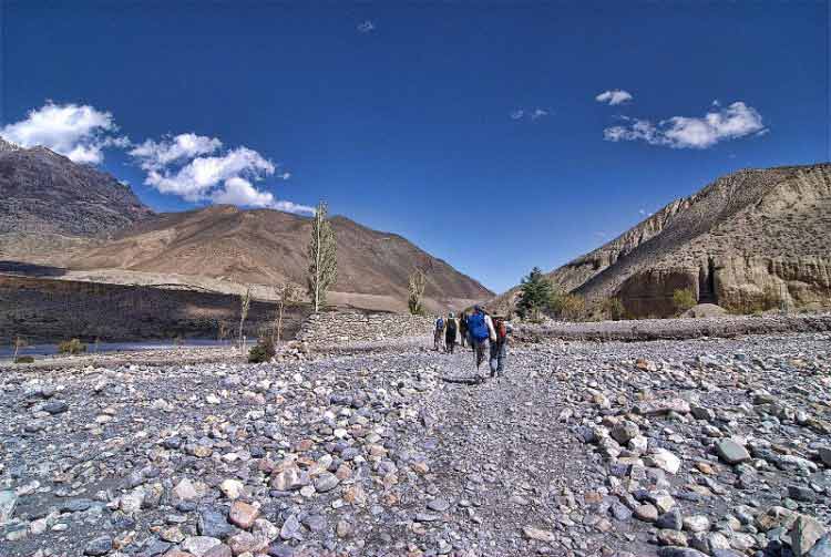
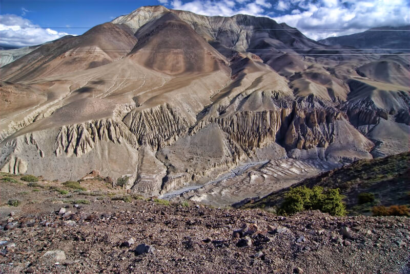
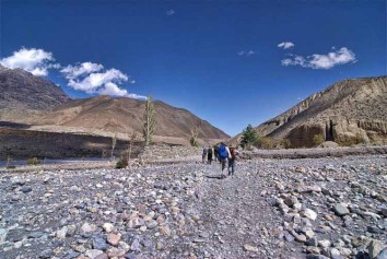
Upper Mustang, in the Upper Kali Gandaki Valley (source of this major river) is a fascinating arid desert in the rain shadow behind the Annapurnas: rainfall 400mm/year. Its landmarks are powerfully wind-sculptured forms in starkly beautiful hues of yellow and grey-brown. Much of the trail is above the tree line but village fields and planted trees soften the landscape.
The Lobas, and the river, rely on snowmelt waters from surrounding high ranges for their very existence. And yet, this hardy people have made the region their home for over 1 200 years. Their mud brick dwellings are clustered in villages along water courses; designed to minimise the effects of the daily winds that blow up the valleys from south to north. Lo Manthang, the capital, is a well fortified walled town where the Raja resides. The palace and several important monasteries and a training centre stand within the walls. A day is set aside to explore the town and surrounding area.
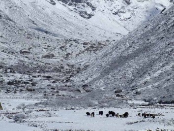
From the 15thC, the town controlled the lucrative salt trade between India and Tibet. Today, that trade has diminished, but their villages and lifestyle are much the same. Yak herds, goats and sheep graze the hillsides while birds, shy bharal and illusive snow leopards roam above.
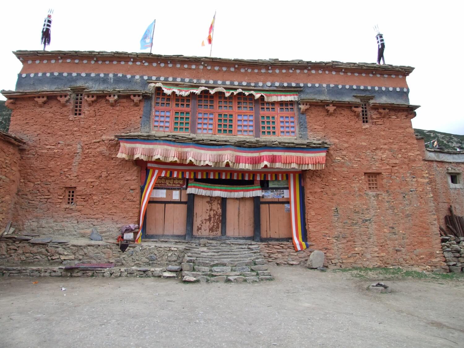
Buddhism and the older Bön animist religion are practised; and now overlap to a degree. Much of the original and unique architecture and art can be explored along the trails. Colourful landmark chortens signify places of importance.
Trekking in Mustang is demanding, but if you are fit and have stamina it offers a magical alternative to the popular trekking routes. Recently, roads from the south and north have been pushed through the region: mostly along the ancient trails. However, the road is not heavily used and gradients are less severe.
The trek begins from Pokhara with a flight up the Kali Gandaki Valley to Jomsom and a walk to Kagbeni; entry village to Mustang. Further north, the trail crosses to the eastern side of the river and undulates over numerous ridges and into tributary valleys carrying melt water to the east. There are five passes with a maximum elevation of 4 325m/14 190ft. The Restricted Region ten day permit is expensive, but rewards from the trek are priceless.
Outline Itinerary
Day 01:Arrival Kathmandu Tribhuvan International Airport (1 300m/4 260ft). We will meet and transfer you to your hotel.
Day 02:In the City Kathmandu Valley Sightseeing Tour OR A day at leisure. Trek preparation.
Day 03:Kathmandu – Pokhara (880/2 900ft), 6-7 hrs drive
Day 04: Pokhara – Jomsom – Kagbeni (2 840m/9 320ft), 25 min flight, 3-4 hrs trek
Day 05: Kagbeni – Chele (3 100m/10 170ft), 5-6 hrs
Day 06: Chele – Shyangmochen (3 800m/12 470ft), 6-7 hrs
Day 07: Shyangmochen – Ghemi (3 510m/11 520ft), 3-4 hrs
Day 08: Ghemi –Tsarang (3 580m/11 750ft), 3-4 hrs
Day 09:Tsarang – Lo Manthang (3 840m/12 800ft), 4-5 hrs
Day 10: Rest and exploration day; in and around Lo Manthang
Day 11: Lo Manthang – Ghar Gompa (3 950m/12 960ft) – Drakmar (3 810 m/12 500ft), 6-7 hrs
Day 12: Drakmar – Shyangmochen (3 800m/12 470ft), 5-6 hrs
Day 13:Shyangmochen – Chhuksang (2 980m/9 780ft), 5-6 hrs
Day 14: Chhuksang – Kagbeni (2 840m/9 320ft) – Jomsom (2 700/8 860ft), 6-7 hrs
Day 15: Jomsom – Pokhara, 25min flight
Day 16:Pokhara – Kathmandu, 25 min flight
Day 17:Final Departure: Transfer to Tribhuvan International Airport for your flight to your next destination.
NB: Cloud and turbulent weather along the mountain ranges is common and may lead to internal mountain flight delays or cancellations. We suggest you add at least one extra day after your trek before flying out of Nepal.
After completing passport, immigration and visa requirements, we will meet you outside the terminal building (look for your name board) and transfer you to your hotel: afternoon free. Evening: a welcome dinner, introduction to your guide and a briefing on the trek with a check on necessities. Overnight at hotel.
Take a day tour to five of the Kathmandu Valley’s cultural world heritage sites: Swayambhunath, the famed “monkey temple”; the city’s historical Durbar Square with ancient temples, unique art and architecture, plus the chance to see the Kumari (living goddess); Patan’s Durbar Square; the Hindu temple Pashupatinath and Bouddhanath, the world’s largest stupa.
A car and driver will take you to each site-entrance and wait for you. (Entry tickets and lunch are not included.)
After breakfast, drive to Pokhara along the Prithvi Raimarg which offers fascinating glimpses of rural Nepal as you pass through Middle Hill scenery and along major rivers such as the Trisuli Nadi, which rises in Tibet north east of Kathmandu. The route passes through the lower Gorkha region (beneath Manaslu), south of the epicentre of the first of the recent earthquakes. Transfer to your hotel. Rest of day free.
After breakfast, board an early morning flight, with good snow-peak views, to Jomsom, administrative centre of the lower Mustang region in the Kali Gandaki Gorge.
Headwaters of the ancient Kali Gandaki Nadi are the Nhubine Himal glaciers in the northwest corner of Mustang: as the Himalayas rose, the river continued to cut its path to the Ganges between the Dhaulagiri and Annapurna ranges; creating the world’s deepest gorge. Hot air on the high, dry Tibetan plains to the north rises daily, drawing cooler air from the lowlands up the gorge between ~11:00 and 16:00 – creating unpleasant dust storms.
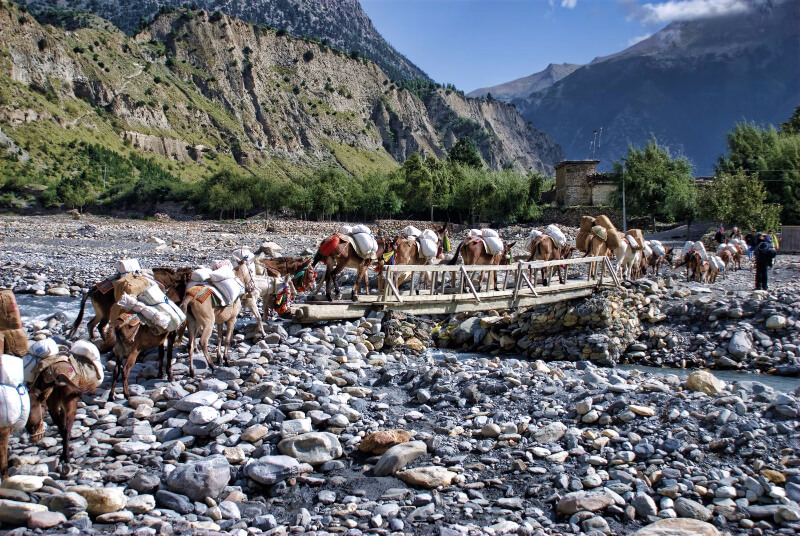
Meet your porters and trek north up the ancient India-Tibet salt trade route: now largely overlaid by the dusty new road. Above the town, the valley broadens and the river meanders across its bed. The road follows the eastern bank to Eklai Bhatti. Beyond, a road heads east to the Hindu and Buddhist pilgrimage site at Muktinath, and the Thorung La to Manang. Follow the road along the river to Kagbeni at the confluence of the significant Jhong Khola tributary that drains the ranges above Muktinath.
The town is ancient and its architecture reflects the harsh conditions of a region that lies in the north-western rain shadow of the Annapurnas. Its verdant orchards and fields are only possible with irrigation from snow-melt river water. The residents are Baragaunle; people of the 12 villages in the southern region of Upper Mustang. Their beliefs are a mix of ancient Bön animistic rituals and a transformed Tibetan Buddhism: common throughout Upper Mustang and Dolpo. Explore the town and visit the old gompa. Nilgiri stands proud south of the town. Overnight in Kagbeni.
The starkly beautiful arid terrain of Upper Mustang (2 000km2) is an extension of the high Tibetan plateau, uplifted by India’s thrust beneath Asia. Population: ~7 000 people. To curb the constant splitting up of scarce fertile land amongst marrying males, polyandry is still successfully practised in Mustang; as it is in Dolpo and the Tsum Valley. These families tend to be more prosperous than couples with children. Alternatively the first son inherits and the second son is placed in a monastery at an early age. For health, people rely on the help of Lama doctors (amchi) who practice Tibetan herbal medicine.
After permit formalities at the ACAP checkpoint, follow the road, east of the river, climbing several attractive ridges to the barley, buckwheat and wheat fields with apple orchards around Tangbe (3 060m). Whitewashed homes line its narrow streets. An hour’s walk leads to the confluence of the Narshing Khola with the Kali Gandaki – and the grouped houses of Chhuksang (2 980m). Caves, ancient walls and the Kanga Gompa stand west of the river.
Further on, the road crosses the river near an enormous fallen rock, beneath which the river has had to tunnel. It then ascends steeply through a rocky gully into the Ghyakar Khola Valley; and the terraced fields of Chele. Overnight in Chele.
The villages from Chele northwards lie to the west of the Kali Gandaki and are, perforce, built along watercourses that can supply sufficient water for irrigation from the glaciers of the high Dolpo region to the west. Average annual rainfall in this rain-shadow region is a mere 250 – 400mm and before spring, the upper Kali Gandaki is often reduced to a slender stream. Villages are thus situated in a series of parallel roughly west-east tributary valleys, carrying the snow melt to the river: leading to numerous vertical undulations along the road and trails.
The hardest section of the trek is tackled this morning with the climb to Samar. The road winds steeply upwards, crossing the tree line into spectacular dry brown desert country. Pass a suspension bridge over the river to Ghyakar, and continue up a rugged canyon to the Chele La (3 630m). Views to the east include Bhrikuti (6 460m) and Khumjungar (6 759) in the foreground of the huge cluster of >6 000m peaks NE of the Thorung La that make up the Damodar Himal. The Thorung La is masked by Yakwakang (6 482m) and other peaks. Tilicho Peak (7 134m) and Nilgiri N (7 061m) crown the southern view.
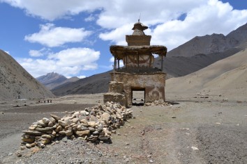
Descend more gently to Samar (3 660m): a poplar-lined watering point for horse caravans. Goats are also used as pack animals in Upper Mustang. Beyond the village, the road undulates between ridges and tributary crossings through several valleys. A colourful chorten landmarks the rise to the Bhena La (3 830m): before dropping to the hamlets of Bhena (3 860m) and Yamdo (3 920m). Ascend the Yamdo La (4 010m), then follow a ridge down to attractive Shyangmochen and great views. Overnight in Shyangmochen.
Begin this, easier, day with a gentle climb to the Shyangmochen La (3 850m): entrance to the next side valley. The road cuts through fields up the centre of the valley, passing the hamlets of Tamagaon (3 710m), Chhungar (3 750m) and Jaite (3 820m) to the Nyi La (4 020m): which marks the southern border of Lo. Descend gently to a ridge-chorten that marks the Ghemi La, then drop steeply through the surrounding fields to Ghemi’s whitewashed clustered homes and narrow alleys: the regions third largest village. Overnight in attractive Ghemi.
Descend to cross the Tangmar Khola beyond which are rocky cliffs in hues of red, blue and grey. Cross the valley and climb, past an extensive mani wall, to the Choya La (3 870m). Stop to enjoy the panoramic view of the Damodar and Annapurna ranges to the south. The road then gradually descends to the fields and fine entrance chorten to the second largest town of Tsarang. It is perched on the edge of a ridge overlooking the Kali Gandaki Valley; reached through the Tsarang Chu canyon. In earlier times it was the capital of the region. Remnants of its glory remain, including a late 14thC five storeyed palace, now unused, and the gompa (which is worth visiting; pujas are held on most days – and guests are invited to attend). Relax and overnight in Tsarang.
Drop down the canyon, cross the Tsarang Khola and follow the Tholung Khola up the valley. The Sungda chorten marks the border between Tsarang and Lo; continue up to the Lo La (3 950m). Below, walled fields and irrigation canals surround the walled capital: a marked contrast to the starkly beautiful yellow and grey-brown desert scenery. Altitude and water constraints allow for a single annual crop of barley, wheat, mustard or vegetables.
As seen from the ridge, the town is built on a plateau and is surrounded by a ¾km perimeter wall. It is L shaped with the single entrance gate on the short base of the L. Approach the gate in a clockwise direction. The palace is the first building inside the gate. The monastic section fills from the top of the L and more, to the right of the palace. In recent times buildings abutting the outer wall have been allowed to develop. Overnight in the capital.
Sightseeing in and around the town offers several options (apart from observing the general bustle):
For the morning, consider:
A visit to the community Namgyal Gompa (and local court) on a nearby hill.
A walk to Tingkhar, in a valley NW of the town with three gompas and the Raja’s summer palace.
A trail beyond Tingkhar passes numerous gompas and a cave (used by the Khampas of Tibet after 1959). A circular route via Garphu would lead you back to Lo along the border road.
Return to the teahouse for lunch before exploring the town. Get permission for photos in the gompas. Consider:
Return to the teahouse for the night.
Leave Lo Manthang, and the road, and trek southwest on herder’s trails to the Chogo La (4 325m, highest trek point). Contour around a valley to a gully and descend to cross the Tsarang Khola before climbing to Ghar Gompa. This 1 200 year old centre was built by the Buddhist sage Padmasambhava: who travelled widely through Tibet and Nepal. It is one of Nepal’s oldest Gompas: particularly known for its valued collection of carved, painted and framed stones on the monastery’s walls.
Trek across a valley and ascend to a ridge through alpine meadows before descending through a gully beneath cliffs and caves of reddish rock to Drakmar: an attractive village divided by a stream. Bharal often frequent the upper reaches. Overnight in Drakmar.
This morning’s trail drops past walled fields and a stream, then undulates over ridges down to Ghemi and on to the Ghemi La (3 765m). Then, on the lower up-slope of the Nyi La is a chorten and a trail to the south of the road that offers an alternative route to Shyangmochen via Geling (3 570m); an agricultural village which has an interesting gompa and artefacts. From there follow a road to Shyangmochen for the night.
go back over the ascendant trail during Yamdo and Bhena to Samar, climb the Chele La to Chele, then drop to cross the Kali Gandaki and follow the road down there to Chhuksang. Overnight in Chhuksang.
Today, retrace the road through Tangbe and head for Kagbeni in time for lunch. After the lunch start again the trek to Jomsom; joining the Annapurna circuit trail from Muktinath at Eklai Bhatti. Relax at your more sophisticated hotel, offer farewell to your porters and enjoy a last evening in the Kali Gandaki Valley. Overnight in Jomsom.
Board an early flight for the short flight to Pokhara. Transfer to you hotel. Rest of day free. Overnight in Pokhara.
After breakfast drive to the airport for the scenic flight back to Kathmandu. Transfer to your Hotel. Rest of day free. Overnight at your hotel.
Transfer to Tribhuvan International Airport for your flight to your next destination.
NB: Cloud and turbulent weather along the mountain ranges is common and may lead to internal mountain flight delays or cancellations. We suggest you allow at least one extra day after your trek before flying out of Nepal.
I know Landmark Discovery Treks in my previous trip in October 2013 when we hired them as our trekking organizer to ABC. We had 14 people, 1 guide and 7 porters in our group. I was impressed by our tour guide Shiva because one of my friend had knee pain and cannot walked fast, Shiva followed her side by side all the way during the entire journey without any pushing even some of the days we walked after sunset. One of my friend got behind the trek and lost in the first day, Shiva was searching him at night with torchlight until he found him. Shiva is a quiet person but he is very humble, patient and caring. We have a wonderful and memorable trip and this is the reason I chose them again in 2016 for my second trekking trip to Upper Mustang.
frederick clwong
25th Apr, 2022
My friends and I did a 10 day trek altogether for the Upper Mustang with Landmark Discovery treks. We had a wonderful time with our guide Bhadri and 2 porters Ghaila and Ganesh. Not only did Bhadri give lots of insight on the culture and lifestyle of the people living in the region, he was also very attentive to the welfare of our whole group. One of my friends had a mild case of AMS on the first few days, but recovered quickly thanks to the medication given by him.
A strong and patient man, Bhadri doubled up as a porter and carried our bags when one of our porters unfortunately fell ill and had to be sent back home halfway during the trip. Nevertheless, he still maintained a good pace during the trek, leading us on, and patiently waited when one of us lagged behind.
All in all, the service provided was excellent throughout, with all our guides and porters tending to all our needs in the best possible way. I highly recommend Bhadri and the rest of the crew for any of the organized treks from Landmark Discovery.
This Upper Mustang trek was undoubtedly the best trekking experience I have had so far with magnificent landscapes and unspoiled natural beauty. I will most certainly be back in Nepal for another incredible experience.
Brigette Y
25th Apr, 2022