Main Navigation

The Kanchenjunga North Base Camp Trek in far eastern Nepal must rank as one of the finest and most spectacular treks in the country. It is remote, sparsely populated and the teahouse facilities are still relatively basic (but improving); the welcome and service is always friendly. The dramatic vistas and sheer scale on this trek are humbling and hugely rewarding. This trekking region was not affected by the recent earthquakes.
From Kathmandu, fly to lowland Biratnagar near the India border and then up to the new airport at Suketar. The trail drops towards the Tamor Nadi that drains this trekking region and follows its valleys up to Hellok where a river from Kanchenjunga’s southern glaciers joins the river. A little north of this, the Ghunsa Khola from the northern glaciers also joins the Tamor. We then follow the Ghunsa Khola Valley to Ghunsa and on to its source.
Five days of walking to the Tibetan village of Ghunsa through hills rich in oak, rhododendron, birch, and bamboo forests, and through Limbu and Rai farming villages below 3 000m, helps prepare for the higher work to come.
Ghunsa (3 400m) lies below steep, snow-capped, forested slopes. After a rest day, the trail climbs to Kambachen, opposite impressive Jannu and above the tree line. It then enters a surreal world of towering peaks: barren on south facing slopes, ice-clad on the shaded north facing giants above the huge Kanchenjunga glacier. Trek up a desolate valley to Lhonak for the night; the last summer yak grazing terrace – above the glacier and beneath huge ice fluted Wedge Peak. Follow the ~12km terrace to the Pang Pema BC for a night. Here, the glacier swings to the south and up to its source on the awesome bulk of Kanchenjunga, four of its 8 000m summits and attendant ridges. Climb above the camp for an unforgettable sunrise. Trek back to Kambachen, Ghunsa and on to Suketar – staying in different villages on the down route.
Outline Itinerary
Day 01: Arrival Kathmandu Tribhuvan International Airport (1 300m/4 260ft). We will meet and transfer you to your hotel.
Day 02: In the City Kathmandu Valley Sightseeing Tour OR A day at leisure. Trek preparation.
Day 03: Fly Kathmandu – Bhadrapur(72m/240ft), 45 minutes flight and drive to Phidim
Day 04: Phidim – Taplejung (1 440m/1 720ft), 95km 6-8 hrs drive
Day 05:Taplejung – Linkhim (1 520m/4 990ft), 5-6 hrs trek
Day 06: Linkhim – Chirwa (1 190m/3 900ft), 5-6 hrs
Day 07: Chirwa - Sekathum (1 640m/5 390ft), 5-6 hrs
Day 08: Sekathum - Amjilosa (2 490m/8 170ft), 5-6hrs
Day 09: Amjilosa - Gyabla (2 730m/8 960ft), 5-6hrs
Day 10: Gyabla - Ghunsa (3 430m/11 250ft), 5-6hrs
Day 11: Ghunsa – rest and acclimatisation day
Day 12: Ghunsa - Kambachen (4 150m/13 620ft), 5-6 hrs
Day 13: Kambachen, rest and Jannu Glacier exploration
Day 14: Kambachen – Lhonak (4 790m/15 900ft), 4-5 hrs
Day 15: Lhonak – Pang Pema (Kanchenjunga North Base camp Lhonak 5 160m/17 200ft), 6-8 hrs
Day 16: Lhonak – Kambachen (4 150m/13 620ft), 5-6 hrs
Day 17: Kambachen – Ghunsa – Phale (3 140m/10 302ft), 5-6 hrs
Day 18: Phale – Amjilosa (2 140m/7 100ft), 5-6 hrs
Day 19: Amjilosa – Chirwa (1 190m/3 900 ft), 5-6 hrs
Day 20: Chirwa – Linkhim (1 520m/4 990ft), 5-6 hrs
Day 21: Linkhim – Taplejung (1820m/5969ft.) 5-6 hrs
Day 22: Taplejung - Ilam (3640m/11939ft.) 6-7 hrs
Day 23: Ilam– Bhadrapur – Kathmandu, 2-3 hrs drive, 45 min flights
Day 24: Final departure: Transfer to Tribhuvan International Airport for your flight to your next destination.
After completing passport, immigration and visa requirements, we will meet you outside the terminal building (look for your name board) and transfer you to your hotel: afternoon free. Evening: a welcome dinner, introduction to your guide and a briefing on the trek with a check on necessities. Overnight at hotel.
Sadly, many of our architectural treasures were damaged in the recent earthquakes: but these sites still have much to offer.
Take a day tour to five of the Kathmandu Valley’s cultural world heritage sites: Swayambhunath, the famed “monkey temple”; the city’s historical Durbar Square with ancient temples, unique art and architecture, plus the chance to see the Kumari (living goddess); Patan’s Durbar Square; the Hindu temple Pashupatinath and Bouddhanath, the world’s largest stupa.
A car and driver will take you to each site-entrance and wait for you. (Entry tickets and lunch are not included.)
After an early breakfast we drive to the domestic airport for the flight to Bhadrapur (Chandragadh) in the south east corner of Nepal. Transfer to a jeep for the drive along the Mechi Highway to Ilam for lunch. Continue to Phidim through middle hill country. Most villages perch high on cooler hill tops with terraces down to rivers on the valley floor. Vehicles have to constantly zigzag up and down on gravel roads – that weather the force of the annual monsoon rains. Speed limits are generally 20km/hr. Overnight in Phidim.
From Phidim the road snakes its way up to Nagi and then swings NW on the new road to Kabeli and Taplejung. A new cross road from Kabeli links Taplejung with Medibung for local use. Overnight in Taplejung
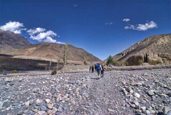
Two trails lead to Thiwa, entrance to the Kanchenjunga Conservation Area. The longer trail drops to the considerable Tamor Nadi that drains the entire region to the north. Our higher, cooler, trail undulates downwards through the Sherpa hamlets of Lakchun, Bung Kulung and Gadi Danda to the Limbu village of Phurumbu; on a ridge above a huge landslide. It then meanders down through the Yaphre and Sisne Khola canyons to Linkhim, on a ridge. Overnight in Linkhim.
Follow the ridge into a canyon and gradually descend to the hamlets of Thiwa and Nagadin above the river. Continue, up and down, to the delightful thatched cluster village of Chirwa, set amongst huge boulders on a bend in the river. Overnight in Chirwa.
Beyond the village, the landscape begins to change as the valley broadens. The trail crosses the tributary Sisuwa Khola and rises to Tapethok (1 320m). This is a wealthy cardamom growing region; the plants, similar to ginger, produce flowers/seeds close to the ground. It is also the permit check point for the Kanchenjunga Conservation Area.
The KCA preserves 2 305km2 of sub-tropical evergreen, temperate and sub alpine pine forests and alpine scrub meadows with ~3 000 plant species. Numerous rare animal species thrive in this sparsely populated and difficult terrain; including herds of bharal, red pandas, illusive snow leopards and 250 bird species.
Two routes lead to Sekathum: the direct route, east of the river, crosses the Tamewa Khola at Tamewa (1 560m) and continues to Hellok (1 740m) at the confluence of the Tamor and Simbuwa Khola that rises from the Yalung Glacier below Kangchenjunga’s south face (and south BC).
The longer trail from Tapethok crosses the river to a well paved stone path west of the river that climbs to hilltop Lelep (1 700m, the KCA HQ). Beyond is a fork: left up to Olangchun Gola of the Walung community on the Lumbasumba Trek; right drop back to the river and a bridge above the Tamor – Ghunsa Khola confluence.
Head into the narrow Ghunsa Khola Valley, that drains the waters from the north Kangchenjunga, Jannu and other glaciers; to Sekathum. A pleasant, simple kharka at Japantar beyond the village also offers a warm welcome. The tip of Khumbakarna’s (Jannu’s) glacial head peeks over the mountains to the north. Overnight in Sekathum.
The Sekathum – Amjilosa – Ghunsa trail stays north of the river. It undulates above the north bank through rhododendron, oak and bamboo forest. Steps then climb past evidence of slash and burn forest removal, to open country and Ghaiyabari hamlet (2 150m). Continue up, more gently, on an exposed narrow trail on grassy slopes to a crest (2 530m) then gradually descend to the tiny settlement of scattered houses that is Amjilosa. Overnight in Amjilosa.
This is a relatively easy day; but the trail does rise 700m. Walk steeply up to a ridge and then contour through bamboo, birch, brown oak and rhododendron forest, descending, past waterfalls and summer kharkas to rapids. Follow the rapids, cross a small, roofed, bridge then climb steeply to the small, flat kharka Sherpa hamlet of Gyabla. The scenery is steadily becoming more dramatic. Forests have been cut back all along the high gentler valley slopes for fields: the southern slopes remain pristine. Overnight in Gyabla.
The trail rises 700m today. Magnificent hemlock, fir and rhododendron forest, with stands of bamboo, shades the trail along the north bank. Descend through a ravine to a long walk on more level ground before the trail gradually rises to the extensive summer yak pastures and potato fields along the ribbon village of Phale (3 140m): for lunch. Their simple wooden gompa has a collection of old thangkas and statues that is worth a visit.
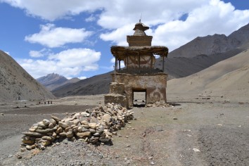
Valley and trail then broaden, meandering downwards through a forest of larches, passing a WWF memorial to lost Conservation Experts. Beyond, a huge rock colourfully emblazoned with ‘Om mani padme hum’ announces the entrance to Ghunsa (winter settlement; now with many permanent residents) – a kilometre beyond and after passing their small Khampa Dzong monastery (linked to the monastery in Lhasa). Cross the river on a swing bridge to a chorten and the village: the largest in the region. Overnight in Ghunsa.
This attractive Tibetan village has homesteads set in plots of land surrounded by fields with wooden fences; giving a sense of spaciousness and quiet calm that is enhanced by the dramatic, huge and sheer forested valley walls. Colourful Tibetan carpets are made here – and could be collected on the down journey.
Visit the monastery. For longer and higher walks, consider the Yamatari Lake beneath the snout of its glacier on the Lapsang La trail. Or, tackle the trail that follows the hydro electric plant’s pipe line up the forested Tamo – Sela La route towards Tortong and Kangchenjunga’s south BC. Look out for grazing Bharal. Return to the village to sleep low.
The trail climbs another 700m today. Trek north, east of the river through magnificent juniper and larch forests. Cross a boulder-strewn and sandy floodplain, then a rickety bridge over the river and continue upwards, fairly steeply, to attractive Rambuk Kharka (3 720m). Forest gradually gives way to alpine scrub as the narrow trail climbs, past a high waterfall and rock falls. Beyond is a dicey trail over a wide landslide, then a steeper trail, past the impressive snout of the Khumbakarna (Jannu) Glacier (on the eastern side of the valley) to a knoll, then a gentle descent into the U-shaped Kambachen Valley; and the village. Jannu (7 710m/25 295ft) and several other peaks rise high above the valley to the east. Yaks and choughs abound and bharals should be seen; soaring lammergeyers, eagles, kites and falcons are fairly common. Overnight in Kambachen.
Another rest day is called for after rising to this altitude. Climb the hill above the village for better views of Jannu. Walk NW up the Nupchu Khola Valley towards the ice fields and peaks above: can be tiring. Cross the river and follow a trail above the Kumbhakarna Glacier to a magnificent viewpoint below Jannu. (A morning walk up the stony Lhonak trail will not lead to better views of the anticipated northern peaks.)
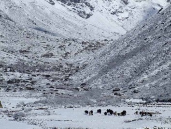
Today’s 600m climb is not strenuous, but care is needed through the stony river bed leading towards the goths (herder’s huts) at Ramtang (4 370m). Ahead is the Kangchenjunga-Ramtang glacier snout. The trail later climbs the moraine then drops over to the stream that flows from the Lhonak Glacier to the north. Cross on an unstable wooden bridge, or ford it, and head up to the huts and campsites on the grassy Lhonak Kharka terrace. These valley terraces were cut by former ice ages and stand above the E-W Kangchenjunga glacier; on the slopes of Drohma Peak (6 850m). The valley is often windy and bitterly cold once the sun disappears. Water can be scarce as the rainfall at Lhonak, in a rain shadow, is far less than that over Kangchenjunga. Overnight in Lhonak.
The feint trail climbs 350m along the terrace above the glacier; over short grasses or rocky tracks that undulate with the terrain. A single hut at Pang Pema stands opposite the southward turn of the glacier to its source. Kanchenjunga has five peaks over 8 000m: Main peak is (8 598m/28 210ft) – earth’s 3rd highest. From Kanchenjunga to Tibet, an unbroken wall, nowhere less than 6 100m forms the border with Sikkim. The views rank amongst the most spectacular in the world. Return to warmer Lhonak for the night.
The return journey from Pang Pema to Lhonak will be fairly slow, but beyond that the route is almost all downhill and thus Kambachen can easily be reached in a day. There are great views to enjoy. Overnight in Kambachen.
Retrace the path down to Ghunsa, for lunch. Look out for pheasants in the forest. Cross the river below the village and continue downstream beside the Ghunsa Khola, through forest and farmland, to the Tibetan summer grazing village of Phale, with its wooden gompa. Overnight in Phale.
The trail, through forests of rhododendron, conifer and birch, continues down the valley, dropping to cross numerous tributaries to the last of the Tibetan villages at Gyabla. It then undulates down to Amjilosa. Overnight in Amjilosa.
After the waterfall beyond the village, the path begins to descend fairly steeply to Sekathum: at the confluence of the Ghunsa and Tamur Kholas. Follow the west bank to the suspension bridge over the Simbuwa Khola from the Yarlung Glacier. An afternoon's walk leads back to thatched Chirwa. Overnight in Chirwa.
From Chirwa, leave the river trail and follow the trail that climbs above the east bank of the Tamor Khola to the hamlet at Thiwa and exit point the KCA. Then climb high above the houses of Tawa and over a ridge before dropping into a side canyon to cross the Tawa Khola before climbing back to the ridge. It then passes above the hamlet of Malbanse before reaching Linkhim. Overnight in Linkhim.
From Linkhim, the trail winds in and out of side canyons back to the Limbu village to Phurumbu and a ridge overlooking a vast landslide before Jogidanda. A final 3-4 hr climb, through the Sherpa villages of Bung Kulung and Bhote Gaon leads to the airstrip at Suketar. Celebrate with a farewell dinner before saying goodbye to your trekking crew. Overnight in Taplejung
The Mechi Highway from Taplejung near Kabeli. The shorter return route to Ilam thus repeats much of the up-route.
Ilam is the capital of Nepal’s tea industry. It offers pristine landscapes of sloped tea gardens below natural forest and has a unique culture. Walk from your hotel to visit an estate above the main street. Overnight in Ilam.
The bus drive to Bhadrapur (Chandragadh) takes you to the town centre. Take a taxi to the airport. An open air kiosk near the entrance serves fresh meals under trees and umbrellas.
After the flight to Kathmandu we will transfer you to your hotel. Evening farewell dinner.
Transfer to Tribhuvan International Airport for your flight to your onward destination.