
Main Navigation

Nepal trekking in autumn season is probably the best time in Nepal. The autumn season falls early September to early December in Nepal. All trekking routes are open for trekking during the season. The crowded high season is mid-September to mid-November with air washed of dust enhancing mountain views. Clouds frequently build in the late afternoon; nights are clear and cold. This is the best season to experience some of Nepal’s many festivals such as Indra Jatra, Dashain, Tihar, Mani Rimdu, etc
Trekking in Annapurna Annapurna trek in northwest of Kathmandu and starting from or near Pokhara. Pokhara is reached with a 5-6 hour drive from Kathmandu through rural middle hill Nepal and south of the high peaks: or fly for 30min to Pokhara. For the circuit treks behind the range drive for 6-7 hours west from Kathmandu to Tal. Two restricted treks (below) begin at Tal or Jomsom’s airport.
(7 to 10 days, 3 210m/10 530ft), drive to Pokhara 5-6 hrs, or fly 25 min Nepal’s most popular short trek will introduce you to trekking: through forest and terraced farmlands at comfortable altitudes. It is crowned by a Poon Hill sunrise over a snow capped panorama – while behind you endless forests of Sal trees stretch southwards towards India. There are several scenic options for the return route, depending on your available time. Children over the age of six can enjoy these treks.

This trek, away from the most popular routes, climbs the slopes of the Annapurna’s sacred Machhapuchhare (Fish Tail) peak. Views across the range are spectacular and close up pics of “the tail” cannot be bettered! Muktinath Temple Complex explore this revered Hindu and Buddhist site.
Drive or fly from Kathmandu to Pokhara and explore the city. Then drive on the recently completed gravel road up the Kali Gandaki Valley to Kagbeni (the first town of Mustang – an ancient Buddhist kingdom in the high, dry and arid region in the rain shadow of the Annapurna range. Drive up to explore Muktinath for a night. Return to Pokhara and Kathmandu.
For this longer trek, drive or fly to Pokhara and then fly to Jomsom. Trek to and explore Kagbeni (2 810m), the first town in Mustang. Then trek to Muktinath. Return to Pokhara on foot following ancient trails (sometimes on the road) used formerly by Tibetan – Indian caravans trading salt with goods from the south. At Tatopani (hot springs) leave the road to trek through pristine rhododendron and oak forests to Poon Hill (for a sunrise panorama of Annapurna’s southern peaks). Return to Pokhara and Kathmandu.
This thrilling trek, north of Pokhara, gradually ascends the Modi Khola Valley (carrying glacial water from Annapurna III to the Ganges). Numerous clean villages, above terraced fields offer good food and accommodation along the route. Trek slowly to acclimatise before reaching the sacred sanctuary and hotels on the glacial moraine. A vast ring of peaks will surround you. The ice wall with Annapurna I towers 4 000m above you across the valley floor. Sacred Machhapuchhare guards the eastern entrance. Adding days will offer visits to Poon Hill and alternative interesting exit routes.
This is the classic trek that starts east of the range and follows an anti-clockwise route around the “back” of the mountains to the high Thorung La pass. It then plunges into the arid Kali Gandaki Valley (in the rain shadow of the mountains) to descend the world’s deepest gorge before swinging around to Poon Hill on the “front” of the range. The building of gravel roads in the east and west has shortened the original route by driving through the dust to the attractive village of Tal. Trek into the Marsyangdi Valley, gradually rising (and acclimatising) before the pass. A rest day in Manang helps – and offers several interesting walks. Trek to Thorung Phedi and rest. Tackle the Thorung La with great west and east views. Descend 1 600m to Muktinath. Drive down to comfortable Tatopani (hot springs 1 190m). Then leave the road and trek through pristine rhododendron and oak forests to Ghorepani. Climb Poon Hill for sunrise over 60km of the high Himalaya including three 8 000m peaks. Hike down to the tarred road and drive to (and explore) Pokhara. Drive or fly to Kathmandu. If you have time add the Sanctuary trek to your Circuit trek (22 days, 5 416m/17 770ft) – you will be fit and this makes a comprehensive end to a glorious trek.
Our popular seven day trek offers you the opportunity to experience the majesty and power of this mountain basin from the serenity and solitude of the lakes. Fitness is required but the route is not difficult and is accomplished in three 1 000m/3 300ft stages up the village trails of the busy Marsyangdi and quiet Dudh Khola Valleys in the Annapurna region. The scenery changes from settled Hindu agricultural villages to Buddhist communities who move to high pastures in the summer months. The route from Goa to Bimthang is through magnificent, pristine oak and rhododendron forest before rising to the stark alpine grandeur of the lakes. Teahouses all along the route are welcoming and comfortable.
An Everest Base Camp trek is seen as the ultimate destination for many trekkers, but the trek is demanding and requires five days at altitudes of over 3 500m/11 500ft. The Namche five day trek, is at comfortable elevations and will show you Everest, Nuptse and Lhotse, amongst many impressive surrounding peaks; will introduce you to the Sherpa people, their culture and customs and take you through the landscapes they have called home for over 500 years. Porters will carry your luggage. Begin with the short mountain flight to Lukla; gateway to the Khumbu region. The trail then drops through forest, farmland and friendly Sherpa villages over two days before rising to Namche Bazaar; for two nights. This is the administrative centre in the Khumbu region: a bustling and sophisticated place that will answer to all your needs. Walk to explore the traditional Sherpa village of Khumjung and experience their lifestyle, skills and warmth. Prayer flags, chortens, and monasteries bring you into contact with their form of Tibetan Buddhism. Return to Lukla – and Kathmandu.
Our eight day trek offers a fuller introduction to the Khumbu-Everest region: the hilltop monastery at Tengboche is the oldest in Khumbu. It faces a glorious southern view of Everest, Lhotse and Nuptse – closer landmarks include Thamserku and Ama Dablam. From the airport at Lukla, local porters will carry your luggage along the trails to centuries old villages. Meet the friendly Sherpas and experience their culture. Prayer flags, chortens, and monasteries bring you into contact with their form of Tibetan Buddhism. Highlights will include the crossing of glacial rivers on sturdy suspension bridges, walking through terraced farmlands (crops changing with altitude); watching skilled craftsmen at work; and being astounded by the loads carried on the backs of animals and porters. The highest altitude at Tengboche is reached after five days of walking.
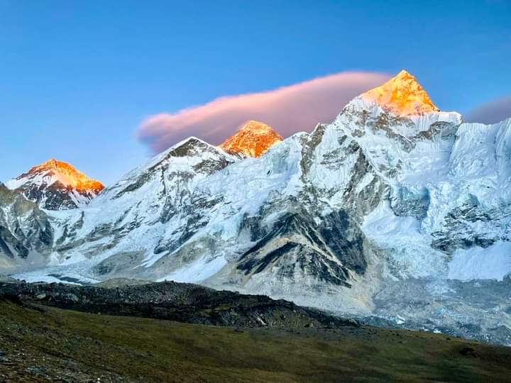
Fly from Kathmandu to Lukla for the start of the classic EBC trek. Follow trails to Sherpa villages that head, between towering peaks, towards Everest. Once above the tree line, you will be closer to the ice-giants than on any other trail. The 13 trekking days are designed to minimize the risk of AMS by limiting daily altitude increases. Two rest days are included as the altitude rises. The first is at Namche Bazaar: explore the town and nearby Khumjung to experience the culture, lifestyle and beliefs of the Sherpa People. The second, after a night at Tengboche, with an important monastery and great views of Everest, is at Dingboche. Hike to the Nangkartshang ridge to view the Nuptse glacier. As the altitude rises, temperatures fall: forests and farmland give way to alpine scrub; then rock and ice. After a night at Lobuche trek to the highest village at Gorak Shep for lunch. Follow the trail to the ring of peaks surrounding the upper Khumbu Glacier – and the ice fall towards the summit. Base camp (5 360m) is laid out annually, in April-May, on the ice opposite the ice fall. Return to Gorak Shep for the night. Climb Kala Patthar, behind the village for sunrise views of Everest and its satellites. Return to Lukla in four easier days, staying at different villages.
A trek to the Gokyo Lakes is an easier, less crowded alternative to an Everest Base Camp trek. The scenery is magnificent and, from a high point above Gokyo includes: Cho Oyu, a dramatic view of the northwest face of Everest, Lhotse, Nuptse and Makalu: four 8 000m peaks at the turn of a head! Below is an extensive view of the kilometre wide Ngozumpa Glacier as well as the ice fields from which it flows. After the short flight to Lukla, walk for two days to Namche Bazaar – for a rest and acclimatisation day. The Gokyo trail follows the tranquil Dudh Koshi Valley west of the Everest Trail. Walk up to the snout of the Ngozumpa Glacier (Nepal’s longest) beneath impressive peaks. Follow its moraine past two lakes to the summer grazing hamlet of Gokyo (4 750m) – built on the slope of the moraine overlooking the blue-green Dudh Pokhari (lake) and surrounded by high peaks. Spend two nights here. A stiff, rewarding climb up Gokyo Ri offers soaring views of four 8 000m peaks, set amongst other giants. A gentle walk further up the valley – to two more lakes – is also possible. The return journey requires three days: staying at different villages.
This comprehensive trek thoroughly explores the central Khumbu region: it includes four high altitude climbs, two to view points. Pre-fitness and stamina is required. The route follows the Gokyo trail for one night in Gokyo. Climb Gokyo Ri for the magnificent views, then, after lunch, cross the Ngozumpa Glacier and walk down to Tagnag for the night. After an early breakfast, tackle the demanding Cho La (5 420m) and descend its glacier to Dzonglha. A short trek to the Everest up-route and Lobuche offers a rest day. Then trek to Gorak Shep for lunch and walk to Base Camp and back in the afternoon. Climb Kala Patthar behind the village for sunrise views of the Everest group, et al – return to your lodge for breakfast. Walk down to Lukla in four easier days.
A new tarred road into the Solu-Khumbu and its capital, Salleri, south of Lukla, offers a unique opportunity to see Nepal’s lowland Terai region (and countries breadbasket) and experience the friendliness of the middle hill Hindu communities. It also offers walk-in access to the Everest region (if you don’t like flying).
The Buddhist Sherpas, who migrated from Tibet some five centuries ago, settled in Nepal’s Solu and Khumbu (Everest) districts. Once away from the road, you walk at the pace of the people and share in their lifestyles. The trail joins the original route from Jiri (followed by Everest’s early explorers) and gradually rises (helping acclimatisation), through forests, villages and farmlands, passing below Lukla, to reach Namche Bazaar (3 440m) over four days. A rest day is taken at Namche Bazaar (business hub of the Khumbu District) to explore the town and region. Trek, through spectacular mountain scenery to the hilltop village of Tengboche. Visit the oldest Buddhist monastery in the region and enjoy great views of the Everest – Lhotse – Nuptse group amongst countless other dramatic peaks. The colourful Mani Rimdu festival takes place at the full moon in October-November. Trek back to Namche and on to Lukla in two days before flying back to Kathmandu.
Pikey Peak, NW of Salleri offers magnificent panoramic views of Nepal’s Himalayan Chain including seven of the eight 8 000m peaks: from the west’s Dhaulagiri I, Annapurna I and Manaslu; the Everest group north of you and to the east Makalu and Kanchenjunga. Enjoy the rhododendrons that flower in April-May and/or the best panoramic views in September-November after the monsoon rains have cleaned the air of dust. Our itinerary is designed to let you explore the region at a steady pace and acclimatise to the increasing altitude. Start from Dhap, south of Salleri. If you are fit and walk regularly, you should not have problems: youngsters over six years could enjoy it with you. No ‘climbing’ is involved. MANASLU TREKS northwest of Kathmandu, east of Annapurna: gaining in popularity, fast.
The Manaslu Himal rises in the north of the Gorkha District in mid-western Nepal. The region contains some of the most beautiful scenery in the Himalaya. The south is peopled by Hindu Newars and Buddhist Gurungs; the north is home to an old Buddhist Gurung and a Tibetan community: speaking two independent dialects. Engaging in this rich cultural mix is one of the highlights of this trek. The topography demands much up and down walking, making this trail quite demanding: and calls for good initial fitness. From Arughat, the up route passes through spectacular natural forest and farmland with countless waterfalls and enticing mountain vistas. Beyond ‘New Bridge,’ (reached on the 5th day) the valley gradually curves to the west between dramatic mountain ranges to the north and south. Manaslu is first revealed on the 8th day. A rest day at Sama Gaon offers a visit to the Pungyen Nunnery on the glacier below Manaslu or a walk to Manaslu Base Camp. A three day trek then leads to high Larkya La beyond which the trail drops into the Annapurna Region through dramatic glacial scenery to warmer villages below. Descend to Tal for a last night before taking a jeep back to Kathmandu (or Pokhara).
The Tsum Valley, north east of the Manaslu trail (entered at ‘New Bridge’ on day 5), was first opened to trekking at the request of the Tsumbas in 2008. The valley lies along the border with Tibet and is one of the most secluded in the Himalayas. ~4 000 Tsumbas live in 18 villages. Little has changed and you are offered a rich glimpse into a bygone era. The topography of the region calls for much up and down walking, making this a fairly demanding trek: good initial fitness is called for. The Tsumbas are of Tibetan origin and maintain a unique culture and form of Buddhism; they speak an ancient dialect. Polyandry is still practised amongst some families; one girl married to the brothers of a family: they tend to be wealthier than ‘conventional families’. Hand worked crops in the short growing season include barley, maize, buckwheat and potatoes. Himalayan tahrs and bharal (blue sheep); preyed on by illusive snow leopards, may be seen on high slopes. Their unique architecture includes impressive square chortens, clustered stone houses and numerous religious centres with ancient art and remarkable views. Mu Gompa (3 709m) and the 800 year old Dephyu Doma nunnery (4 000m) are the ‘end destinations’ and highest permanent places of year-round habitation. Return to Kathmandu by the same route.
Trek up to ‘New Bridge’ and then spend seven days in the Tsum Valley before returning to cross ‘New Bridge’ to complete the Manaslu Trail and Larkya La crossing. Trek to Tal and take a jeep back to Kathmandu (or Pokhara).
The Helambu District is just north of Kathmandu: the start of the trek is reached by an hour’s drive. The trail winds through the forests of the Shivapuri National Park (Kathmandu’s water catchment area) before entering Helambu. It then follows ridges as it rises, through forest and terraced farmland to its highest point at Tharepati – with great views of the High Himalaya to the north and east. The route then swings east and south to Tarkeghyang. This Yolmo village has the oldest monastery in the region; built in the Bhutanese style. After a short downward walk on the fifth day, return to Kathmandu by jeep.
The Langtang Valley lies between two impressive ranges south of the Tibetan border. Trek over hills to the southern slopes of the Langtang Valley through mixed forest rich in wildlife; farmlands surround friendly villages. Cross to the drier northern slopes and gradually ascend to the U-shaped valley carved by the Langtang, Shalbachum and Lirung glaciers. The trail leads to the Kyanjin Gompa village – for a rest day. Hike up Tserko Ri for spectacular panoramic views of the High Himalaya along the Tibetan border; including nearby Langtang Lirung and its glaciers plus Shisha Pangma, China’s only 8 000m peak. The return trek follows a different lower route to the road at Syabru Besi with views of the Ganesh Himal.
Gosaikunda is an alpine region south of the Langtang Valley that lies along the Chalang Danda (ridge) offering great views to the north and south. The lovely Gosaikunda Lake system is sacred to Hindus and Buddhists. While there should not be a problem with the altitude on this “short” trek; five days are spent above 3 000m/9 800ft and it is recommended that trekkers arrive fit and used to walking. Beyond the lakes the highest point on the Laurebina La (with breathtaking 120 km Himalayan views) is reached – followed by a long descent of 1 200m/3 900ft for a more comfortable night. The trail continues south, into the fir and rhododendron forests of the Helambu District. Friendly Brahmin, Chhetri, Tamang and Yolmo groups will welcome you to their villages before you trek through the Shivapuri National Park – for an hour’s drive back to Kathmandu. Also consider our combined Langtang – Gosaikunda – Helambu Trek (17 days, 4 600m/15 100ft).
Western Nepal Best times: May to October
Only fully catered camping treks are possible in this glorious region. This demanding trek requires a restricted area permit costing US$500 for the 10 days in Upper Dolpo. It includes eight nights at over 4,000m/13,100ft, calling for fitness, careful acclimatization and slow ascents of three (different) high passes. Dolpo lies in the rain shadow behind the Dhaulagiris where snow fed streams supply water, but few are perennial. Lower (Outer) Dolpo is semi arid with deep gullies and forested valleys. Upper (Inner) Dolpo is a vast, high and awe-inspiring arid region of semi-desert mountains: a continuation of the Tibetan plateau. Dolpo covers 15% of Nepal’s area and is home to a scattered, population of <5 000 hardy people who practise their ancient Bön or Buddhist faiths: both represented throughout the region. They are yak and goat herders, growing millet, buckwheat and potatoes in the short summers. Fly from Nepalgunj in far eastern Nepal to Juphal (where final supplies are collected) and trek to Lake Phoksundo. Then enter the restricted region of Upper Dolpo and trek to Shey Gompa and on to Saldang, the largest village in the region. A day’s trek northwards visits an 800 year old Bön monastery before turning south to the diverse Do Tarap valley; then back to Juphal.
Upper Mustang, in the Upper Kali Gandaki Valley (source of this major river) is a fascinating arid desert in the rain shadow behind the Annapurnas: rainfall <400mm/year. Its landmarks are powerfully wind-sculptured forms in starkly beautiful hues of yellow and grey-brown. Much of the trail is above the tree line but village fields and planted trees along snow-melt water courses soften the landscape. From Pokhara, fly to Jomsom and trek to Kagbeni to enter the region. The trekking is demanding, but if you are fit and have stamina it offers a magical alternative to the popular routes. Recently, roads from the south and north have been pushed through the region: mostly along the ancient trails. However, the road is not heavily used and gradients are less severe. Teahouse accommodation is everywhere available. The Restricted Region ten day permit is expensive ($500), but rewards from the trek are priceless. This trek is possible during the monsoon season – although rain delays in flying to Jomsom may be encountered (add extra days).
The Nar and Phu valleys (north of the Annapurna Trail) are home to people of Tibetan origin who speak a unique dialect of the Tamangic languages spoken along the Annapurna trails; but are unintelligible to the people of the Manang Valley. They have remained isolated from the lower valley for centuries, choosing to trade across a high pass with Tibet. The route north of the Annapurna trail requires four long trekking days – and two rest days to explore Phu and then Nar. Trekkers can then either return to Tal and Kathmandu (in 3 days: total 12 days) or continue west to Manang and complete the Annapurna Circuit Trek to Pokhara (in 11 days, total 20 days). The best time to explore this region is in late September and October (when snow is least likely to be a problem.) It is also possible to link the Na-Phu trek to the Mustang trek along a high linking route.
Kanchenjunga’s combined north and south Base Camps Trek in far eastern Nepal is demanding but the scenery ranks amongst the most spectacular in the country. It is remote, sparsely populated and the teahouse facilities are relatively basic; but improving. The dramatic vistas and sheer scale of the scenery is humbling and hugely rewarding. The flora and fauna is rich and varied with spectacular forests that change with altitude. Getting to the region is cumbersome as there are no regular flights to Taplejung. Fly to Bhadrapur in SW Nepal then drive by jeep to Taplejung through Ilam’s tea estates. The north BC trail follows the Tamor Nadi (that drains the entire region). Rise gradually to 3 400m at Ghunsa over five days. Trek to Kambachen before entering a surreal world of towering peaks: barren on south facing slopes, ice-clad on the shaded north facing giants above the 21 km dark, rubble-covered Kanchenjunga glacier. Trek to Lhonak for two nights in a simple lodge; the last summer yak grazing terrace above the glacier. Follow the ~12km terrace to the Pang Pema BC (5 140m) to view the awesome bulk of Kanchenjunga with its four 8 000m summits and attendant ridges. Return to Ghunsa. To reach South BC requires a two day trek over five passes to Tseram. Walk north to Ramche. An early morning start for ~1½ hours leads to the view-point chorten (~4 800m) on the white Yalung glacier for great views of Kanchenjunga’s southern snowy ramparts. Cloud may obliterate the views later in the day. The downward trail follows the Yalung Khola to Tortong. Then climb a ridge into a new world overlooking endless green forested hills with scattered villages and farms. Descend over five days to Medibung for a jeep to Ilam, and Bhadrapur. Fly back to Kathmandu.


