.png)

Main Navigation
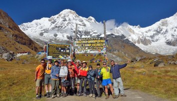
Nar Phu - Annapurna Circuit Trek is an adventure into the mystical lost valleys of Nar and Phu and the enthralling Annapurna Circuit, along with the high passes of Kang La and Thorung La. The Nar and Phu valleys (north of the Annapurna Trail) are home to people of Tibetan origin who speak a unique dialect of the Tamangic languages spoken along the Annapurna trails; but are unintelligible to the people of the Manang Valley. They have remained isolated from the lower valley for centuries, choosing to trade across a high pass with Tibet. The valleys and forests are home to some rare species of Himalayan wildlife, creating the possibility of encountering herds of blue sheep, thar or even the elusive snow leopard.
In late 2002, this high region (mostly 3 500m) was opened, at their request, for trekking in Nepal to restricted area. Simple tea house treks are now possible, but are demanding as the tea houses are few and far between. A restricted area permit, only issued to two or more trekkers with an official guide, is needed to enter this region.
The route north of the Annapurna trail requires four long trekking days – and two rest days to explore Phu and then Nar. Trekkers can then either return to Tal and Kathmandu (in 3 days: total 12 days) or continue west to Manang and complete the Annapurna Circuit Trek to Pokhara (in 11 days, total 20 days). The full trail is described below. The best time to explore this region is in late September and October (when snow is least likely to be a problem.)
Drive from Kathmandu to Tal in the Marsyangdi Valley. Trek from Tal to Koto. Then head north into the narrow Nar Valley, trekking through forest along trails cut from the rock walls at times. As the trail climbs, the valley, and scenery broadens. The region is dry – in the rain shadow behind the Annapurnas; rocky landscapes in dramatic parched colors contrast to water-course vegetation (from higher snow melt). Winter grazing lands hint at habitation during the summer months when the residents have moved to higher, cooler land. Views back over the Annapurnas increases with altitude. Brightly painted landmark chortens stand in important places.
The northern triple-village of Phu has a main section with ~40 houses stacked up the side of a ridge. Only barley, potatoes and vegetables can be grown in the short growing season; yaks, goats and sheep graze on the kharkas: their wool used to produce cloth and carpets. The Tashi Lhakhang Gompa covers an adjacent hill. Snow peaks surround the town.
Nar has a larger community in 65 homes and four gompas set on a rocky curve above green fields. It is a livelier village with people tending to congregate in a central area. This unique region offers insights into a bygone world.
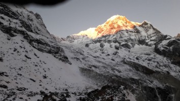
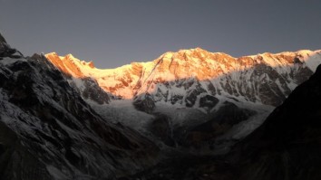
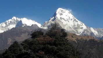
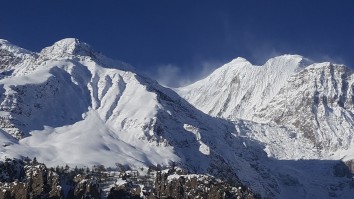
Trek along the ancient trade routes and cross Kang La Pass (5315m) to witness astounding views of Annapurna, Gangapurna and Tilicho. Descend through Manang, and onto the Annapurna Circuit route next. Ascend the Thorung La (5416m) to reach the highest point of the trek and enjoy the amazing scenery from the summit; including the Annapurna Massif, Dhaulagiri, Machhapuchhre, Manaslu, Gangapurna, Tilicho Peak, Pisang Peak and Paungda Danda.
Further highlights on the trail include the sacred Hindu and Buddhist pilgrimage site of Muktinath. Muktinath, which translates to ‘place of liberation’ is a centuries old temple, dedicated to the primary deity of the Hindu pantheon, Lord Vishnu.
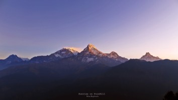
Pass through Tatopani, home to rejuvenating natural hot springs and eventually reach Ghorepani. A pre-dawn climb to the grassy ridge at Poon Hill offers a panorama of Annapurna, Manaslu, Dhaulagiri and Machhapuchhre, shimmering in the sunlight.
Descend further through Tadapani to the Gurung village of Ghandruk, a modern settlement home to the Ghandruk Cultural Museum (visit if time permits to learn about Gurung culture and history).
The trek ends with a short trek further to Phedi. The Nar Phu – Annapurna Circuit Trek comes to a closure with a drive to Pokhara and a scenic flight back to the capital.
The best times of the year to perform the Nar Phu - Annapurna Circuit Trek are during spring (March to May) and autumn (last week in September to mid-December) seasons. During these periods, the weather remains stable and the mountain views are good leading to the best experience. Rhododendrons in full bloom on the hills with clear skies and crystalline mountains in the back drop is a classic sight. In monsoon, the weather can be unpredictable and the rain can make the trails slippery and perilous. During winter, the temperatures can drop harshly low and the pass can get blocked off in case of excessive snowfall.
This 23 Days Nar Phu - Annapurna Circuit Trek is a strenuous trek that takes you up to altitudes of 5416m (Thorong La Pass). You will be trekking over steep hills and semi rocky terrain for most of the trek. While no technical climbing skills are required for the trek, some prior trekking experience will certainly make the trek easier. However, good physical fitness and stamina is a necessity. Remember to set aside ample time for acclimatization and stay hydrated.
NRS. 3000 ($30) per person
NRS. 1000 ($10) for organized trekkers
NRS. 2000 ($20) for independent trekkers
NRS. 7500 - 9000 ($75-90) per person per week
After completing passport, immigration and visa requirements, we will meet you outside the terminal building (look for your name board) and transfer you to your hotel: afternoon free. Evening: a welcome dinner, introduction to your guide and a briefing on the trek with a check on necessities. Overnight at hotel.
Take a day tour to five of the Kathmandu Valley’s cultural world heritage sites: Swayambhunath, the famed “monkey temple;” the city’s historical Durbar Square with ancient temples, unique art, architecture, and the chance to see the Kumari (living goddess); Patan’s Durbar Square; the Hindu temple Pashupatinath and Bouddhanath, the world’s largest stupa.
A car and driver will take you to each site-entrance and wait for you. (Entry tickets and lunch are not included.)
The westward journey to Dumre (and Pokhara) winds over the forested Middle Hills that separate the High Himalaya from the Nepali and Indian lowlands. The road links Hindu villages and terraced farming communities, crossing several important rivers that flow from the ice fields to the north. At Dumre we turn north into the Marsyangdi Nadi Valley. A secondary road leads to the important centre of Besi Sahar (760m). A minor road then heads into the hills, passing construction work on a major hydro electric scheme and heads for Syange (1 080m).
The road now enters a canyon and rises to a ridge: and Jagat (1 330m, a former salt-route toll depot to Tibet). Continue, through Chamje (1 410m) to a ‘bus stop’ opposite a suspension bridge to the east bank and a short walk to Tal. This attractive village is set in a flat valley behind which is an impressive waterfall (and palm trees). The river flows placidly between gabions. Overnight in Tal.
We now follow the Marsyangdi Nadi, towards its source on the North Annapurna Glacier. The trail passes barley, wheat and potato fields and then begins a long steady climb through pine forests before crossing to the road on the west bank near Khotro (1 860m). Walk up the road to Dharapani (1 960m): a bustling Tibetan village in the Manang valley, at the confluence with the Dudh Khola. (A trail up the Dudh Khola leads to Manaslu.)
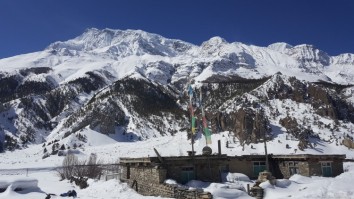
The valley swings westwards and the trail climbs steep forested ridges, over some landslides, as it ascends the southern slopes of the valley. Good views of the Lamjung Himal, Annapurna II (7 937m), and Annapurna IV gradually rise to the south as we approach Koto. Overnight in Koto.
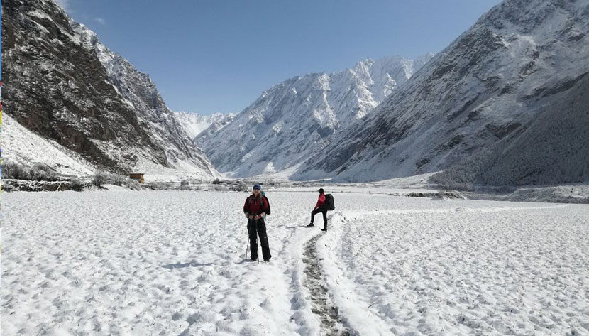
The Nar and Phu Valleys lie north of Koto and are reached via the Nar Khola Valley. The next four trekking days are long and demanding as the teahouses are (at present) few and far between. Many of the route place-names refer to winter kharkas (warmer, lower grazing fields, only used by the inhabitants during the cold season). Fill water bottles regularly as long sections of trail can be dry. Trail views back over the Annapurnas are spectacular.
This high region, >3 500m, is home to ~800 people who speak Nar-Phu (Narpa to the Manangis): a dialect of the Tamangic language group that is not intelligible to the Manangba along the Annapurna Trail. Tibetans residing at the monastery at Nar have had a greater effect on the language than influences from Nepal. The monastery’s traditions have led to a degree of Tibetan literacy (through religious texts); and more recently, a Nepali school has introduced some Nepali.
At their request, both valleys were opened to restricted trekking in late 2002: to date this has had little influence on their language or culture. Nar and Phu each have a development committee: for conservation and preservation. The main occupations are small scale farming, yak herding and more recently the lucrative collection of seasonal Yartse Gumpa; mainly for the Chinese market. They still trade with Tibet (via a difficult pass to the north that was never used for the salt trade).
Cross the Marsyangdi Khola and trek north, west of the river, up the deep Nar Gorge through dense ancient forest. At times, the trail is carved into the rock, high above the river. Later, cross to the east bank and a tributary before an ACAP campsite. Picnic along the route.
As the gorge narrows, climb well above the river through stands of pine and bamboo; before crossing back to the west bank as the river veers to the NE and Hudaki Odar (3 060m, postman’s cave). Later cross to the east bank, pass behind a waterfall – and continue to Dharamsala (3 220m, resting place for pack animals).
Traverse for 1¼hrs up a side valley; along the slopes of Kang Garu Himal past sheep goths (herder’s huts). Zigzags then lead up to a chorten (3 540m). The Nar ridge and Pisang Peak (6 091m) feature to the west, the Lamjung Himal (6 983m) to the south. Walk on through terraced fields to Meta (Nar’s winter settlement). Overnight in Meta.
Trek out of Meta’s basin to a chorten and a fairly level trail to a junction overlooking the Nar Valley to the west. Nar Phedi is visible below. Nearby, is the confluence of the Phu and Labse Kholas, major tributaries to the Nar Khola. Head north, past occasional kharkas, to Nar Phedi and a higher trail to Nar. Continue up, into juniper forest, to a chorten, and Jhunam (3 640m, one of several former Khampa outposts). Drop down a side stream before a steep pull up a glacial moraine, to a series of chortens that mark the trail to Chyakhu (3 800m). From Upper Chyakhu the trail steepens, crossing the Mruju Khola before swinging back towards the Phu Khola to a pass landmarked with flags – and wider Annapurna views. Ahead is Kyang (Phu’s winter settlement) on a plateau. Picnic along this route.
Beyond Kyang, the vegetation changes to alpine juniper scrub and grasses; enjoyed by shy bharal herds. The trail drops to cross the Phu Khola then ascends the east bank of the gorge: at first on a narrow hewn cliff side trail, past a bridge to steps and on up into an S-curve that gradually passes dramatically eroded rock towers. Later, it zigzags up, past an impressive tower and over a rock bridge to the Phupi Gyalgoe Gate (entrance to the Phu region). Ahead are Phu’s three villages, and the ruins of former fortifications. Follow the trail across an eroded hillside before dropping to a colourful line of impressive chortens before a bridge to Phu’s main village. Overnight in Phu.
Phu (head of the valley) is built on a spur above the confluence of the Phu and Kyajo Kholas. Its ~40 mud brick houses are stacked up the slopes of the spur. The highest construction is the remains of the original fortified building. Sheep, goats and yaks are kept for labour and trade; barley, potatoes and vegetables are grown for local use in the short, high summer months. Most of the region is blanketed in snow during winter: the residents and their livestock move to lower winter pastures. Explore the town, its local cuisine, and look for traditionally woven blankets and clothing.
Visit the large Tashi Lhakhang Gompa complex that stands high on an adjacent hill, beneath the snow pyramid of Chako (6 704m). Anis (nuns) will show you the main hall with a fine collection of masks, instruments and thangkas. The complex contains a library and apothecary for herbal medicines. Many Lamas study herbal medicine to become Amchis (herbal doctors) in these isolated regions. A kora (pilgrim path around sacred sites/mountains) surrounds the gompa with birds’ eye views over the town. Good overviews can also be had from a hill south of the town on the trail to Ubi.
For acclimatisation walks, hike towards the Himlung Base Camp below Himlung (7 125m) or, more easily, to Ngoru Kharka. Overnight at the teahouse.
The return route is easier and faster: with Annapurna Himal views from open ground. Drop back to Kyang and continue to the juniper forest around Jhunam. Beyond, walk down (~¾ hr) to the higher trail junction to the west (right) that drops past eroded gullies and a ruined fort to twin bridges over the narrow and deep Dho Khola gorge. (~10 min on, a trail to the left descends to Nar Phedi).
Our trail must now climb 600m (~2½ hrs) to Nar. The first hour is fairly steep; Kang Garu gradually comes into view. The trail then eases as it approaches the Nar gate, a goth and mani wall before curving around a ridge to add Pisang Peak to the views. Further on, climb a stile over yak pen walls to an impressive octagonal chorten.
Nar (place of bharals) soon appears: its ~65 houses for ~200 villagers are stacked, curving around a natural bowl above barley fields. Overnight in Nar.
Nar is busier than Phu: take time to explore its byways and the central area where residents tend to congregate. Apart from farming and tending to their livestock, wool is spun for weaving and rug making: for local use and trade in Tibet. There are four village gompas, worth exploring: the Samten Pelgye Gompa contains fine old statues. Overnight at the teahouse.
Make a pre-dawn start from Nar, through its lower kani and climb gradually, through yak pastures to a contour that leads around the valley to Kang La Phedi (4 620m, ~1½hrs, high camp). Views of Pisang and its imposing ridge improve with altitude. In good weather the 700m, 2½hr ascent to the pass is not difficult unless snowbound. Zigzag up to a chorten, then curve along a ridge to a river and follow its left bank up more zigzags to another cairn (4 990m, overlooking the Nar Valley). Later traverse around a small lake before tackling a steep set of zigzags up to the landmark flags, cairn and razor-ridge that is Kang La.
The sweep of the magnificent Annapurna Himal bursts into view; and highlights the downward trail. The ~3hr descent is steep and tricky at first, over loose scree which becomes easier as the gradient lessens; assisted by zigzags. As the gradient eases, the trek becomes a walk through yak kharkas down to the attractive village of Ngawal – and the Annapurna trail. Overnight in Ngawal, at a more comfortable altitude.
Descend gradually to Mungji (3 500m), with a nunnery above the village. Next, is picturesque Braga (3 470m): with clustered houses stacked one above the other up a craggy slope. An impressive Gompa sits at the top. This is the oldest and best endowed gompa in the Manang District. Manang is a short walk from Braga. Rest and explore the village – and its culinary delights. Overnight in Manang.
Today is a scheduled acclimatization day. Walk to either the Gangapurna Lake or the Bocho Gompa. The Himalayan Rescue Association office has informative information on the symptoms of Altitude Mountain Sickness. Return to your teahouse for the night.
From Manang climb NE to Tengi (3 690m) then up and out of the Marsyangdi Valley; turning NW into the Jarsang Khola Valley. Ascend slowly to minimise altitude problems.
The trail passes summer kharkas through scrub juniper as it steadily climbs above Gunsang (3 920m): a cluster of flat mud roofs below the trail. Continue to Ghyanchang (4 000m) before dropping to cross a tributary; then rising through kharkas of grazing horses and yaks. Later, a wooden bridge, heads towards an ancient mani wall and the small village of Yak Kharka; with great views. Overnight in Yak Kharka.
A short day’s slow, steady 500m climb leads to the seasonal outpost before the pass. The path snakes through desolate high scenery: scrub vegetation gradually giving way to rock, scree and an exposed path across a landslide before reaching the trekker-lodge at Thorung Phedi (foot of the hill). There is a single teahouse with a warm cosy dining room and beds for some 150 trekkers. It closes for the winter months. Overnight in Thorung Phedi.
Further up the “hill” lodge staff man a small stone teahouse on a cold exposed ridge: known as High Camp. Rather stay at Thorung Phedi than head for this elevation: just for a shorter summit day.
A pre-dawn start is wise for this long arduous day. There is a 900m/3 000ft ascent before a 1 600m/5 250ft descent. From the teahouse the path climbs steeply up the valley: leading to a stiffer ascent up an ancient moraine. After that, it ascends more gently. Thorung La is a flag bedecked col between Thorung Peak (6 211m/20 378ft) and Yakwakang’s (6 482m/15 434ft) stupendous cliffs.
Views back to the east are snowy. Ahead and far below is the brown desolate scenery of the rain-parched Kali Gandaki-Mustang Valley. On the opposite side of the valley, the huge Dhaulagiri range rises to the southwest. Ahead and to the north, the mountains of Dolpo stretch to the horizon: these are an extension of the Tibetan uplands to the north.
After photos and a rest, begin the ~4hr descent to Muktinath. Tread with care as the path drops steeply over loose gravel. Later, it becomes rockier and easier to walk on. The captivating scenery and chance to “sleep low” should spur you on.
Eventually, the important Hindu and Buddhist pilgrimage site of Muktinath will come into view. This oasis of springs is surrounded by a lengthy wall and is bedecked by thousands of prayer flags. There is a small Vishnu temple and smaller Buddhist shrine: testament to Nepal’s religious harmony. The Tibetan name for this oasis is Chu Mig Tsa Gye (108 springs).
The dusty village of Ranipauwa (3 710m, and traffic) is a 10 minute walk beyond the shrine. The region is collectively known as Muktinath. Overnight in Ranipauwa.
A rutted road has been built, mostly along the trekking trails, from the lowlands to Muktinath. A recent Chinese road from Tibet through Upper Mustang meets this road below Kagbeni (2 840m: consider a detour to this fascinating ‘first village’ into Mustang.) From ~10:00 to 16:00, daily winds blow in dust from the lowlands and now the gravel road makes trekking particularly unpleasant.
Jeep transport has become preferable through this rugged scenery; and returning vegetation. Jeeps are used for the drive to Jomsom (2 760m, administrative centre of the Lower Mustang region). Change to a second jeep for Tatopani (hot springs). From there we leave the road and Buddhist culture – and trek into lush forest once more. Overnight in Tatopani.
The trail enters the Ghar Khola Valley which swings south east towards the front of the Annapurna Range. Most of the trail is through protected rhododendron, oak, birch and magnolia forests; rich in wild life. Ghara (1 780m), Phalate (2 390m) and Chitre (2 420m) are agricultural villages on high ridges: with views of Dhaulagiri and the Annapurnas. The large tourist village of Ghorepani is below Poon Hill. Overnight in Ghorepani.
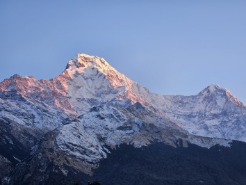
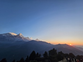
An early, ¾ hr, steep trek leads to Poon Hill’s grassy knoll. This landmark viewpoint offers unobstructed vistas of the high Himalaya from Dhaulagiri I (8 172m) and Upper Dolpo in the west, across the Annapurnas (Annapurna I, 8 019m), to Machhapuchhare (6 997m, Fish Tail) and east to Manaslu (8 156m). Behind: an ocean of Sal forests stretch to lowland India.
After breakfast, trek east through pine and rhododendron forest, over numerous ridges, to Tadapani: with occasional flat sections and wonderful views of the snow peaks to the north from high ground. Overnight in Tadapani.
Today offers a short, downhill trek through farmland and forest with occasional peak views to Ghandruk: a modern Gurung village. Afternoon free: to explore the area; and village museums. Overnight in Ghandruk.
The trail drops down stone staircases to the Modi Khola: from Annapurna’s South Glacier in the breathtaking Annapurna Sanctuary. Cross the river and walk up to Landruk (1 620m) then through scrub bush to Tolka (1 790m). A further ~2 hr trek, through lovely forest ascends to the ridge village of Deorali (2 150m). Views of Pokhara and Lake Phewa are Behind are the last views of Dhaulagiri, Annapurna wall. The trail then drops down a broad red-earth track (that is lethal when wet) to Pothana. Overnight in Pothana.
An easy descent leads to the agricultural village of Dhampus (1 700m) then smaller hamlets with rice paddies to Dhampus Phedi on the Pokhara – Baglung highway: for the short drive to Pokhara and your hotel. Afternoon free: to explore the lake and waterfront; or visit the Mountain Museum. Overnight in Pokhara.
After breakfast, drive to the nearby airport and fly back to Kathmandu along the Himalayan Range. Transfer to your hotel. Afternoon free.
Transfer to Tribhuvan International Airport for your flight to your next destination.