Main Navigation

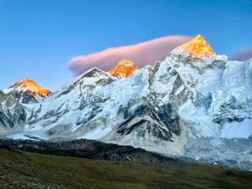
Pikey Peak Trek offers a wonderful and fairly easy introduction to peak climbing: crowned with magnificent panoramic views of Nepal’s Himalayan Chain including seven of the eight 8 000m peaks: from the west’s Dhaulagiri I, Annapurna I and Manaslu across the Langtang to the Mahalangur’s Everest and Lhotse (Cho Oyu is hidden) then further east Makalu and Kanchenjunga. Rhododendrons flower in April-May. Panoramic views are at their best after the monsoon when the air is cleared of dust.
The majority of Nepal’s Sherpa people reside in the Khumbu, Pharak and Solu regions of the Mahalangur (Everest) Himal. Solu lies to the south of Khumbu, Pharak (and the airport at Lukla) and is home to Sherpa, Tamang, Rai and Magar communities’ et al. Sherpas migrating away from eastern Kham in Tibet first arrived in this region ~600 years ago.
The new Sagarmatha Raimarg tarred road in southern Nepal leads to Salleri (the whole region’s administrative headquarters) offering easier access for exploration of the forested middle hill country south of the high ranges – and at comfortable altitudes.
The drive to Salleri and the trails offer a unique opportunity to see the low Terai region and experience Nepal’s friendly middle hill communities. Once away from the road, you walk at the pace of the people and share in their lifestyles.
The 11 Day Pikey Peak Trek is designed to let you explore the region at a steady pace and acclimatise to the increasing altitude. If you are fit and walk regularly, you should not have problems: youngsters over eight years could enjoy it with you. Also known as the Dal Bhat trek, Pikey Peak trekking is generally performed as a teahouse trek.
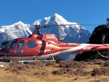
The journey commences with an 8 hour drive from Kathmandu to Dhap. A short trek of 3-4 hours from Dhap to Jhapre will provide you a feel of the terrain and climate and an introduction to what trekking in Nepal feels like. The trail then takes us to the Pikey Peak Base Camp, where we’ll camp for the night. After an early morning ascent to the summit of Pikey Peak, we will witness an astounding sunrise view of the region which includes Everest, Makalu, Kanchenjunga, Numbur Himal and many others. Afterwards, we will continue on our trail through Kande and Junbesi and have an off day to explore Thubten Choling monastery. From Junbesi, it is a short trek further to Salleri. A half hour flight or 8 hour drive from Salleri will take you back to the capital depending on your budget and preference.
The best times of the year to perform the Pikey Peak Trek are during spring (March to May) and autumn (last week in September to mid-December) seasons. During these periods, the weather remains stable and the mountain views are good leading to the best experience. The blooming wildflowers during spring make the trails extra pleasant to walk on as well. In monsoon, the weather can be unpredictable and the rain can make the trails slippery and perilous. This region is prone to heavy rainfall during monsoon.
Pike Peak Trek is a moderate difficulty trek that takes you up to altitudes of 4000m. You will be trekking over steep hills and rocky terrain for most of the trek. Previous trekking experience or technical climbing skills are not a necessity for this trek. However, decent physical fitness and stamina is recommended. As the max altitude is only around 4000m, altitude sickness is normally not an issue as well.
After completing passport, immigration and visa requirements, we will meet you outside the terminal building (look for your name board) and transfer you to your hotel: afternoon free. Evening: a welcome dinner, introduction to your guide and a briefing on the trek with a check on necessities. Overnight at hotel.
Take a day tour to five of the Kathmandu Valley’s cultural world heritage sites: Swayambhunath, the famed “monkey temple;” the city’s historical Durbar Square with ancient temples, unique art, architecture, and the chance to see the Kumari (living goddess); Patan’s Durbar Square; the Hindu temple Pashupatinath and Bouddhanath, the world’s largest stupa.
A car and driver will take you to each site-entrance and wait for you. (Entry tickets and lunch are not included.)
From Kathmandu drive east to Dhulikhel (turnoff to Tibet) then enter the Sun Koshi valley (dropping to 360m). Geography then forces the road south into the Terai and Bardibas; then west on the Mahindra Raimarg, to Karjamha. The recently tarred Sagarmatha Raimarg then winds north, through forested hills to Dhap. (From Dhap the road continues to Salleri; headquarters of the linked Solu-Khumbu region.) [An imaginary east-west line through Lukla roughly divides the southern Solu from the northern Pharak and Khumbu regions.] Overnight in Dhap.
Today’s route winds northwest through terraced farmlands and stands of mixed forest (rhododendrons flower in April-May). Views of Solu’s sacred Shorung Himal [between Nimbur (6 959m) and Khatang] as well as Everest above other peaks to the east appear in the north from high ground. Enjoy lunch in Sigane before trekking along the Phokle Danda (ridge), past a hydro electric scheme that serves the region, to Jhapre. Overnight in Jhapre.
The trail gradually rises to Tolu Gompa (3 370m) then follows the Lamje Danda to Lhamuje Gompa (3 500m); forests gradually give way to alpine scrub. The trail then heads north to Bhulbhule for lunch and good Everest views. Follow the Toriphule Danda; to visit a dairy producing yak-cheese – then continue on to the lodges at the Pikey Peak Base Camp. Overnight at Base Camp.
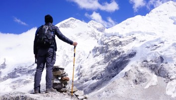
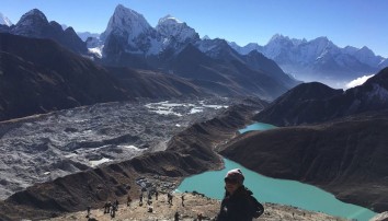
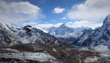
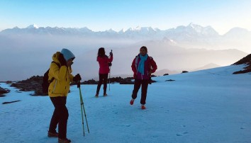
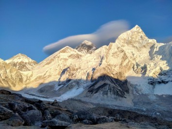
A pre-dawn start could offer spectacular sunrise views of the high Himalaya to the north. The trail, conveniently stepped in places, rises up the western flank to a fairly flat top (~1½ hours). If clear, a magnificent panoramic view of Nepal’s Himalayan Chain will include seven of its eight 8 000m peaks: from the west’s Dhaulagiri I, Annapurna I and Manaslu across the Langtang to the Mahalangur’s Everest and Lhotse (Cho Oyu is hidden) then further east is Makalu and Kanchenjunga. Return to the lodge for breakfast.
Descend to meet a cross-trail and head northeast, through oak and rhododendron forest to a teahouse, viewpoint and lunch at Jasmane Bhanjyang (3 550m). The afternoon walk continues through forest, heading north to join the Jiri-Everest trail at Kande (3 740m). Overnight in Kande.
Today’s route is largely downhill and beyond the teahouse at Lamjura La (3 530m) swings east into the Taktor Khola Valley where coniferous forest gives way to mixed terraced farmland on the lower slopes . Overnight in Junbesi
This attractive Sherpa town, beneath the sacred Shorung Himal ice fields, offers interesting walks to several Buddhist monasteries on the surrounding slopes. Alongside the yellow-topped village Stupa is the largest of the 30 ‘Hilary Schools’ built by Everest’s conqueror. Explore the Tashi Thongmon Gompa, in the village centre; founded in the 16th.
The Thubten Chholing Monastery (2 920m, ½ an hour above the village on the Junbesi Khola) is home to nuns and monks. It was founded by Trulsik Rinpoche in the 1960s, after they fled from the Rongbuk Gompa in Tibet in 1959 (the ‘entry’ point to the N Everest BC and summit route). It is now one of Nepal’s largest. Expect a warm reception and an invitation to explore the monastery.
An additional (or alternative) venture is to walk east towards Phurteng for excellent views of the Khumbu Valley’s peaks including Thamserku, Kangtega, Mera and the Everest group. Return to Junbesi for the night.
[The landmark Numbur (6 960m, or Shorung Yul Lha: god of Solu) – Khatang (6 853m) ice ridge dominates the valley to the north – and gives rise to the Solu Khola that flows southwards to its confluence with the major Dudh Khola (from the Cho Oyu ice fields).
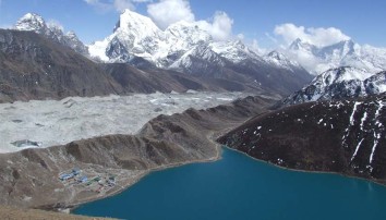
The sacred Dudh Kund (lake) is isolated on the high glacial moraine. Hindu and Buddhist pilgrims visit the lake for the August full-moon. Local communities named the upper section of the Solu Khola the Dudh Kund Khola – as far south as Benighat.
Sherpas settling south of the Khumbu named their region Solu after the river. The area gradually expanded to include land to the west and south of the river. An 86 MW hydro-electric scheme is currently being built on the Solu Khola.
Due to the changes in altitude, soils and the length of the growing seasons the crops grown in the Solu, Pharak and Khumbu regions are markedly different. Solu is the ‘bread basket’ of the region. However, much of the food required by trekkers in the upper valleys has long been carried in by porters from lower regions; or more recently helicopters.]
Cross to the east bank of the Junbesi Khola and walk south alongside the river to its confluence with the Dudh Kund Khola at Benighat. Below the confluence the gradient eases and the valley broadens. Continue to Phaplu (with an airport) and on to the Solu Khumbu’s administrative centre at Salleri; it is worth exploring. Overnight in Phaplu
After an early breakfast, begin the return drive to Kathmandu. Transfer to your hotel. Rest of day free. Evening farewell dinner.
Transfer to Tribhuvan International Airport for your flight to your next destination.