Main Navigation

Manaslu Tsum Valley Trek is one of the most exotic and adventurous trekking trips in the remote and secluded area of Nepal, rarely visited by outsider. Furthermore, this trek allows to discover the secret Tibetan Buddhist lying at the edge of isolated part of the valley. The region is untamed and less explored in comparison to other trekking region, with relatively virgin and less trodden path. Therefore, very few trekkers have made it to this mysterious valley which used to be important trade route to Tibet.
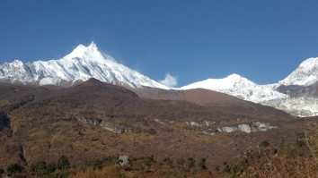
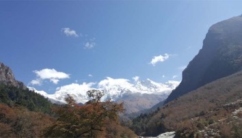
This 23 day Manaslu Tsum valley trek provides an opportunity to unwind into the stunning panorama of Ganesh Himal, Siringi Himal and Boudha Himal range. In addition, this quaint valley, which once used to be the part of Tibet, presents unique scenery and looks completely different; found nowhere else in the world. While on the trek to Manaslu Tsum valley, we traverse alpine forest, glacial rivers and perceive warm hospitality. Also explore age-old Gombas – Rachen Gompa, Mu Gompa, Dephyudonma Gompa.
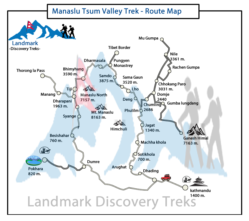
A scenic drive from Kathmandu through lush mid hill takes us to the trail head beyond Arughat at Soti Khola. And then the Manaslu Tsum valley trekking trail follows the forested route and crosses numbers of ridges and scattered village as it climb up to Philim. Here we witness traditional way of farming barley, maize, buckwheat and potatoes. We then follow the route of Chhekempar, Nile and Mu Gompa with incredible backdrop of Himalayans and discovery of authentic cultures. We have designed this 24 days Manaslu Tsum valley trek itinerary to allow proper acclimatization and exploration.
Tsum Valley Overview
The Tsum Valley in Nepal, north east of the Manaslu trail, was first opened to trekking region at the request of the Tsumbas in 2008. The valley lies along the border with Tibet and is one of the most secluded in the Himalayas. ~4 000 Tsumbas live in 18 villages. As a result, little has changed and you are offered a rich glimpse into a bygone era. The topography of the region calls for much up and down walking, making this a fairly demanding trek: importantly good initial fitness is called for.
The Tsumbas are of Tibetan origin maintain a unique culture and form of Buddhism; they speak an ancient dialect. Polyandry is still practised amongst some families where one girl married to the brothers of a family. Most of all, they tend to be wealthier than ‘conventional families’. Hand worked crops in the short growing season include barley, maize, buckwheat and potatoes. Himalayan tahrs and bharal (blue sheep); preyed on by illusive snow leopards, may be seen on high slopes.
Their unique architecture includes impressive square chortens, clustered stone houses and numerous religious centres with ancient art and remarkable views. In addition, Mu and the 800 year old Dephyu Doma Gompas are the ‘end destinations’ and highest permanent places of year-round habitation.
The Rachen and Gumba Lungdang Nunneries welcome visitors: the latter to a simple overnight stay and participation in their evening puja. With their 360o views including the Ganesh and Baudha Himals, this is a highlight of the trekking.
Overnight at different villages on the return trek.
Best Season for Manaslu Tsum Valley Trek
The best time of the year are (March to May) during spring and last week in (September to mid-December) during autumn. The peak season is October. During these seasons, the weather remains good and so are the mountain views.
Manaslu Tsum Valley Trek Permits and Rules
It is mandatory to obtain permits for the Manaslu trek. This is because of the restriction imposed to protect the fragile ecology and culture of the region. As a result, to trek to the Manaslu Tsum valley, travelers need three kinds of permits issued by Government of Nepal
1. Manaslu Restricted Permit:
During the month of (September to November), Manaslu Trek Permit costs USD 100 for first seven days per person. And each additional day costs USD 15 or convertible foreign currency.
During the month of (December to August), Manaslu Tsum valley permit cost USD 70 for first seven days per person and USD 10for each additional day.
2. Manaslu Conservation Area Permit (MCAP)
MCAP And ACAP cost for SAARC national in Nepali currency: NRS. 300 per person
ACAP and MCAP cost for other Nationals in Nepali currency: NRS. 3,000 per person
3. Tsum Valley Restricted Permit
The cost of Tsum valley restricted area permit is USD 70 per person per week.
Manaslu Tsum Valley Trek Itinerary
Day 01: Arrival Kathmandu Tribhuvan Airport (1 300m/4 260ft). We will meet and transfer you to your hotel.
Day 02: In the City Kathmandu Valley Sightseeing Tour OR A day at leisure. Trek preparation.
Day 03: Kathmandu – Arughat (670m/2 200ft) – Soti Khola (710m/2 330ft),Machha Khola (890m/2 920ft) 150km, 8-9 hrs drive
Day 04: Machha Khola – Dobhan (1 000m/3 280ft), 6-7 hrs
Day 05: Dobhan – Philim (1 590m/5 216ft), 6-7 hrs
Day 06: Philim – Chumling (2 390m/7 840ft), 6-7 hrs
Day 07: Chumling – Chhekampar (3 030m/9 940ft), 5-6 hrs
Day 08: Chhekampar – Nile (3 360m/11 020ft), 4-5 hrs
Day 09: Exploration day: Nile – Mu Gompa (3 700m/12 140ft) – Chhekampar (3 200m/9 940ft), 6-7 hrs
Day 10: Chhekampar – Gumba Lungdang (3 200m/10 500ft), 5-6 hrs
Day 11: Gumba Lungdang – Ripchet (2 470m/8 100ft) – Lokpa (2 240m/7 350ft), 7-8 hrs
Day 12: Lokpa – ‘New Bridge’ (1 670m/5 500ft) – Bihi Phedi (1 990m/6 530ft), 6-7 hrs
Day 13: Bihi Phedi – Namrung (2 660m/8 730ft), 4-5 hrs
Day 14: Namrung – Lho (3 180m/10 430ft), 3-4hrs
Day 15: Lho – Sama Gaon (3 530m/11 580ft), 5-6 hrs
Day 16: Sama: Rest and exploration day: Birendra Tal / Pungyen Gompa / Manaslu Base Camp
Day 17: Sama – Samdo (3 860m/12 660ft), 3-4 hrs
Day 18: Samdo – Larkya Phedi/Dharamsala (4 460m/14 630ft), 3-5 hrs
Day 19: Dharamsala – Larkya La (5 160m/16 930ft) – Bimthang (3 720m/12 200ft), 7-9 hrs
Day 20: Bimthang – Gho (2 560m/8 400ft), 5-6 hrs
Day 21: Gho – Dharapani (1 920m/6 300ft) – Tal (1 700m/5 580ft) 3-4 hrs
Day 22: Tal – Besi Sahar (760m/2 495ft) – Kathmandu (1 300m/4 260ft), 190km, 7-8hrs drive
Day 23: Final Departure: Transfer to Tribhuvan International Airport for your flight to your onward destination.
NB: Cloud and turbulent weather along the mountain ranges is common and may lead to internal mountain flight delays or cancellations. We suggest you add at least one extra day after your trek before flying out of Nepal.
After completing passport, immigration and visa requirements, we will meet you outside the terminal building (look for your name board) and transfer you to your hotel: afternoon free. Evening: a welcome dinner, introduction to your guide and a briefing on the trek with a check on necessities. Overnight at hotel.
Take a day tour to five of the Kathmandu Valley’s cultural world heritage sites: Swayambhunath, the famed “monkey temple”; the city’s historical Durbar Square with ancient temples, unique art and architecture, plus the chance to see the Kumari (living goddess); Patan’s Durbar Square; the Hindu temple Pashupatinath and Bouddhanath, the world’s largest stupa.
A car and driver will take you to each site-entrance and wait for you. (Entry tickets and lunch are not included.)
Drive west from Kathmandu towards Pokhara through Middle Hill rural communities to Malekhu. Cross the Trisuli and head north to Dhading Besi. A slow, rutted, dirt road then heads NW: over the Gola Bhanjyang (with panoramic views of the Baudha and Ganesh Himals).
(Beyond this occasional views of Ganesh IV and VI will be seen above the valley walls as far as Khorlabesi. Shringi Himal appears from Salleri to Philim, from where Baudha Himal is also visible. Baudha and the Ganesh Himal are spectacular from Gumba Lungdang. Manaslu is not visible from the Tsum Valley and is first seen on the walk up to Lho.)
(Beyond this occasional views of Ganesh IV and VI will be seen above the valley walls as far as Khorlabesi., from where Baudha Himal is also visible. Manaslu is first seen on the walk up to Lho.)
Drive on to Arughat and the Budhi Gandaki that drains the Manaslu–Tsum region. A further ~4 hrs drive up the west bank leads to Machha Khola. Overnight in Machha khola.
Cross the Thado Khola, descend stone stairs then follow the bar to Khorlabesi (970m, coffee and tobacco crops). The GHT trail through Gorkha (and Barpak, epicentre of the first quake on 25/04/15) crosses our trail, heading east from Manaslu to the Langtang then Everest regions.
Enter a lush narrow gorge constricting the river’s progress. Cross a landslide with a dicey path, before the three hot spring spouts in Tatopani (930m). Climb a ridge then cross the Budhi Gandaki (to avoid a cliff face and waterfalls). A staircase then leads to a landslide before climbing to a ridge; and Dobhan. Overnight in Dobhan.
Exit over the Dobhan Khola, then follow the east bank to the hamlet of Thulo Dhunga (1 840m); above cataracts. Later the gradient lessens, the valley opens and the water is placid at Yaruphant (1 170m). Cross the Yaru Khola (from Ganesh II and VI) on an old suspension bridge then climb to the teahouses at Thado Bharyang. Cross back to the west bank and ascend gently to the old paved village of Jagat (1 410m): entrance and checkpoint to the Manaslu Conservation Area.
Cross a tributary before a cliff-side trail to Salleri: with views of Shringi Himal (7 187m) to the north. Descend to Sirdibas; and the first symbols of Buddhist culture. A final bridge beyond Ghatta Khola (1 480m, water mills) to the east bank, leads to a steep climb up to Philim: a prosperous Gurung village set amongst millet and maize fields; see the Chholing Sandu Gompa. Overnight in Philim.
The trail winds through scrub and lush grasses up the beautiful narrowing valley to the high millet fields of Chisopani, then Ekle Bhatti (1 600m, one house). Gradually descend, past a spectacular waterfall, into the narrow lower gorge: and a junction, left to ‘New Bridge’ and the Larkya La. To the right a well-graded trail zigzags up through blue pines and rhododendron, to Lokpa in the narrow Lower Tsum Valley. Tsum has 18 villages and is home to ~4 000 people.
Drop down through forest, before tackling a long, steep climb up the south wall of the Siyar Khola gorge; above the river draining Tsum. The ‘summit’ is landmarked by flags; overlooking colourful potato, bean and grain fields with Shringi Himal above. Descend to Gumlung and cross the river: for a final, gentler ascent to Chumling. The buildings are classic Tibetan but with sloping roofs to shed rain and snow. Overnight in Chumling.
The trail crosses the river to new forest on an old landslide. Pass a water powered prayer wheel on a ‘Nepali flat’ trail in deep forest: look out for chattering white-faced langurs. At Tanju (2 480m) the small Damphe Gompa houses hundreds of small Chenresig (Buddha of Compassion) ceramic statues: a common feature in Tsum’s gompas.
Beyond Dumje there are views of Baudha Peak and the Ganesh Himal. Beyond Rainjam Farm, cross the Sarphu Khola: draining the Syakpa Glacier from Shringi Himal. Then climb for ~2½ hrs, past Gho through birch, larch and pine forest, to the broad relatively flat Upper Tsum Valley.
Landmark slate chortens facing Ganesh II precede a kani gate to the, now joined, villages of Chhokang and Paro; collectively called Chhekampar (place of wisdom). Houses nestle together to maximise agricultural land for barley, buckwheat, maize and potatoes: crops that ripen in high, short growing seasons. Yaks graze in pastures, tahrs graze along cliffs: and need monitoring to prevent crop losses. Overnight in Chhekampar.
Two days, with numerous attractions are spent NE of Chhekampar: a full morning is needed N of Nile to visit the Mu and Doma Dephyu Gompas. The Siyar Khola flows SW down the centre of the valley; two bridges cross it: the first before twin Ngakyu and Leru (just S of the Rachen Nunnery), the second N of Lamjung and Milarepa’s Cave. A road has been started in this region!
Northwest of the Siyar Khola:Walk up and through the attractive, joined villages of Ngakyu and Leru (3 200m, with mustard fields and apple orchards). Continue to Lama Gaon (3 300m) and Burji (3 380m, where a key and Rs300/p ticket can be secured to visit the cave: best visited on the ‘up day;’ Rachen on the way down.)
A ~½hr tricky side path leads up, past chortens to Milarepa’s Caves (Piren Phu – Pigeon Cave) on the slopes of Langju Himal. There is an impression of Milarepa’s foot, an elephant shaped rock and two small gompas: one over his meditation place, the other devoted to local Nyingma-pa deities. The old retreat monastery, Chi Phu, clings to slopes higher up.
Southeast of the Siyar Khola:N of the cave, the trail crosses the second bridge to the SE bank, joining the Rachen – Nile trail before Phurbe (3 250m). Walk up to Pangdun (3 260m, its gompa has a large prayer wheel). The valley now curves gently to the N, passing an unusual stupa before an entrance kani (gate) to Chhule (3 350m, Chhu Li, shady side). The 700 yr old and well-endowed double storeyed Gonhgye Monastery is ½ hr to the east, with great views.
Cross a tributary (from a high waterfall) and then the Siyar Khola: climb to Nile (Nyi Li, sunny side) on the NW bank. The glaciers of Pashubo stand along the eastern border. Overnight in Nile.
This can be a long but rewarding day. Set out early for the <2hr trek past snow ridges to Mu Gompa (3 700m, 70 yrs). This is Tsum’s highest and last permanent settlement and overlooks the valley and western Ganesh Himal, including Ganesh I. Climb above Mu for a steep ¾ hr to the tiny Dephyu Doma Nunnery (4 000m, 856 yrs, place of the birth of light) perched on an unlikely slope: but with magical, exclusive views of Ganesh II and part of the western Himal.
The trail continues N of Mu to high grazing kharkas (pastures) with goths (herder’s huts): a few with seasonal teahouse facilities on the two pass routes to Kyirong in Tibet.
Return to Nile for lunch then retrace your steps to Phurbe and on to the extensive walled grounds of Rachen Nunnery (3 240m, 110 yrs, of the Ngak-pa-sect; that forbids all animal slaughter). Visit the intimate original monastery which stands in the SW corner of the complex, near the gate. Its old murals depict the history of Buddhism. Residential cells for the nuns and retreat buildings are set along and within the walls. A new, imposing light and airy temple with deities in tall glass-fronted cases now stands further back in the grounds.
Cross the bridge below Rachen and walk back to Chhekampar for the night.
Return to the grouped chortens and descend into the Lower Tsum Valley and the gompa at Gho. Turn south, and cross the river to Dumje (Gumba Monastery owns a small school, herbal medicine clinic and fields here). A ~3 ½ hr stiff climb through glorious oak, rhododendron and pine forest leads to a landmark mani wall (and gompa views): then an exposed section before snaking up through giant silver pines to a ridge and the Nunnery. This is another dramatically placed site with tremendous all-round views. Gumba Lungdang (110 yrs) is currently home to ~20 nuns. Expect a warm welcome and attend their evening puja. Morning views should offer one of the trek’s highlights. Overnight on the Gompa veranda.
Descend through the forests to a small chorten and left fork onto a narrow trail to cross the Langdang Khola. Later climb steadily crossing two high bridges over impressive narrow gorges up to Ripchet: an agricultural village cut from surrounding forest. After lunch, drop steeply down stairs to Gumlung at the river before re-tackling the forested pass and final ascent back to Lokpa. Overnight in Lokpa.
Descend to the trail junction from Philim; drop to ‘New Bridge’ over the Budhi Gandaki (shortly before its confluence with Tsum’s Siyar Khola) and follow the trail as it curves NW into the Manaslu Valley. A broader trail gradually rises, through bamboo forest to Deng [1 800m, entry to Kutang/Lower Nupri (‘Nubri,’) - within Tibet until the 1840s]. The people are Gurungs who speak a unique dialect, practice Buddhism and still trade with Tibet.
Cross to the E bank and climb to Rana (1 980m). Tight switchbacks end at a log-bridge tributary-crossing before an isolated water mill. The trail then gently descends to Bihi Phedi; still high above the river. Overnight in Bihi Phedi.
Undulate above the river before dropping to cross the Serang Khola (far below the Serang Gompa) and later enter an S-bend between basalt walls. Rocky crags rise to the E, with a waterfall high above fields of wheat and maize. The valley broadens as it curves W: cross to the S bank shortly before a kani into attractive Ghap (2 250m); for lunch.
Ascend, through bamboo and bird-filled forests. Cross to the N bank past sheer rocky walls. The river then becomes constricted by hard rock; a short wooden bridge (over a natural rock tunnel) returns to the south bank as the water thunders below. A steep 1 hr trail leads up and away from the river to Namrung. En-route are views of the substantial Tum Khola from the Tibetan highlands: that adds its volume to the lower river at its (unseen) confluence. Namrung is a permit checkpoint. Overnight in Namrung.
This is the entrance to Upper Nupri (western mountains). Its people, formerly from Tibet, speak a unique dialect, favour chubas as common dress and continue to trade with Tibet.
The trail through maize and barley fields to Barsam is gentle. (Night guard towers, manned to scare off marauding bears, dot fields from Deng to Shrip). Climb more steeply to Lihi (2 900m, homes are grouped in clusters beneath one shingled roof). Ganesh II appears east of the valley and landmark chortens herald views of Himal Chuli (7 893m) south of the trail.
The trail then enters a side valley, crosses the Hinang Khola (and a trail to the Himal Chuli BC). It climbs steeply to a detailed chorten land marking the ice walls of Himal Chuli to the south. Beyond are the clustered houses fields and apple orchards of Sho (2 960m). Good views continue as the trail ascends to the hamlet of Shrip.
From Shrip, the trail curves up towards Lho: and reveals the 8th highest peak: Manaslu (8 156m/26 760ft, which, from the Sanskrit manasa – ‘intellect’ or ‘soul’ gives ‘Mountain of the Spirit’); Manaslu North and Naike Peak. A steep climb ends on the ridge in the attractive village of Lho.
The stone houses are shingled and many have distinctive wooden decks. The imposing Ribung Monastery above the village houses ~150 monks. A kani beyond the village, past an ancient mani wall and chortens, offers the best spot for dusk and dawn pictures. Overnight in Lho.
The Budi Gandaki flows deep in the valley north of the kani and viewpoint. Descend steeply to cross the Damonan Khola tributary. Then follow a stream up through glorious mixed forest. A short final climb leads to a plateau: and the badly deforested region around Shyala (3 520m). Peaks rise on all sides: Himal Chuli (7 893m) and Peak 29 (Ngadi Chuli, 7 873m) to the south; Manaslu and glaciers ahead; snow-capped peaks to the north and west.
Later, cross a new bridge over the Numla Khola that drains Manaslu’s Pungyen Glacier. Beyond, a trail heads (left) to Pungyen Gompa on the glacier. Walk down the attractive, broad valley past a school and extensive barley and potato fields to a large chorten.
Enter Sama through a yellow kani and pass a gompa (smothered in mani stones) to rows of low stone dwellings with front courtyards.
Only upper Manaslu and the Naike ridge can be seen from the village. Overnight in Sama.
Sama is Nupri’s regional centre. Explore its architecture, customs and home industries. Items made for trade in Tibet include cloth for chubas and woven rugs using local or imported yarn from sheep and goats. Horses, Yak and Dzopkyo (yak-cow cross) herds are bred for trade.
Beyond and above the village is the 700 hundred year old Kargyu Chholing Monastery (or Labrang: Lama’s Place); its architecture is unique and has fine woodwork. The largest of its eight temple buildings is the Pemba Chholing Gompa, with an impressive statue of Guru Rinpoche. It is owned by the Nyingma Buddhist sect whose Lamas are permitted to marry; and live within the complex. (Regrettably much of the Labrang was destroyed in a fire on 18 February 2015.)
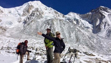
A short walk beyond the monastery leads to the Birendra Tal (3 450m, lake) below the Manaslu Glacier. View it from a hilltop or drop to a stony beach which offers striking views of the terrain. 1½hrs
A demanding trail above the far side of the lake (reached from a path at the bridge over the outflow stream) climbs ~1 200m past the glacier’s snout to the Manaslu Base Camp (4 900m), 5-6 hrs
A trek to the Pungyen Nunnery (3 870m), on a ridge above the Pungyen Glacier; offers superb views of the Nadi ice-ridges and Manaslu towering over the gompa.
To reach the gompa, return towards Shyala, passed the school to the turnoff. The trail heads over a ridge above the Numa Khola and drops onto the Pungyen Glacier. Walk to the ridge on which the gompa is built. ~2½hr. The route can be very cold and slippery; take refreshments.
In 1953, much of the gompa was destroyed in an avalanche – and was only recently rebuilt. Blame for the avalanche was apportioned to the first Japanese (unsuccessful) expedition to Manaslu. They were the first to conquer it – in 1956. 5-6hrs Return to Sama for the night.
A pleasant and easy walk today. Pass the lake, the BC trail and several mani walls. Birch and juniper stands cover the hills surrounding Kermo Kharka above the now north flowing Budhi Gandaki. Later, a stone wall across the valley separates the Sama and Samdo herds. Further on, a spur rises ahead, between the river from the Sonam/Mayol Khola off the Sonam Glacier NE of the trail. Drop to cross the Budhi on a wooden bridge just below their confluence and then the Sonam Khola.
Climb steeply up the spur to a stone arch amid fields. Walk to a white kani at the entrance to Sama: a cold, cluster village against a ridge. Tibetan residents had summer grazing rights to this region, but with the political changes in the late 1950s they fled to Sama and constructed the slate roofed stone dwellings. It is a yak and goat herding post on the trade route to Kyirong; with holding pens amid fields behind the village. This is the last village in Gorkha. The next is Gho in the Manang District (Annapurna region). Several kharkas have teahouses in between.
The vegetation has now changed to alpine low grasses, rhododendron and juniper scrub. After lunch, follow yak tracks up the steep flag bedecked spur behind the village for magnificent 270o views. To the east, along the border, is Sonam Peak (6 335m) with an unusually demarcated glacial moraine. Ahead is the Sama Valley and ranges to the south of Manaslu (hidden by a rocky peak). The view to the west shows tomorrow’s route to Bimthang – and Larkya La along the Larkya Glacier. In the foreground the Syacha Glacier from Manaslu North curls around the foreground peak. Overnight in Samdo.
Drop for the final crossing of the Budhi Gandaki below the former Larkya Bazaar site (3 650m, a popular seasonal trading post before the border was closed). The diminished stream flows from the northern Pana Danda Valley: where a trail leads to two passes to Tibet. Our trail heads west and climbs gently through low scrub above the Syacha Khola and glacier. Its descent from Manaslu North can be seen up that valley.
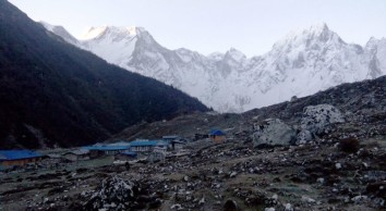
The trail steadily ascends towards the Larkya Glacier’s snout beyond the hidden Larkya Phedi which gradually comes into view. This seasonal kharka had a kitchen with dining room, 15 small double rooms in two rows and two tunnel tents; each with eight beds plus a third for trekking staff. Better views of the Naike (6 291m) and Larke (6 249m) peaks can be had from higher up the side of the valley. Rest and overnight in Dharamsala.
Larkya La involves an 800m, 3-5 hr ascent (when snow free) and a 1 500m, 3-4 hr descent to Bimthang. It can be bitterly cold if windy; snow and ice will demand more time. Snow poles mark the route along the moraine: it is not difficult or steep, but is long and everywhere rocky underfoot.
A pre-sunrise start begins with a gentle ascent to a ridge before a long ascent to the vast, jumbled moraine field. Ahead Pawar Peak on the northern border wall of Cheo Himal and Larke Peak on the southern Larkya Himal gradually appear above the moraine. Walk past the first of four small scattered lakes. Finally a steady pull curves towards Larke and the first group of summit flags. The reverse view overlooks the trail, distant Sonam Peak and ranges into Tibet. The Cheo and Larkya Himal ridges block views to the north and south.
Ahead, a moraine ridge, separated from the Larke wall by a parallel gully leads, for ~30 min, to a second set of landmark flags: and the boundary between the Manaslu and Annapurna conservation regions. They also overlook astounding views into a huge semi-circular basin ringed by a mix of magnificent ice peaks and eroding grey rocky walls. Within, three glaciers flow towards the southwest corner.
From north to west, the landmark peaks are Pawar (6 620m), Cheo (6 820m), Himlung (7 126m), Gyaji Kung (7 030m) and Kang Garu (6 981m). Further east Annapurna II (7 937m) rises above lesser peaks.
From the flags, drop steeply off the moraine and then carefully descend the, steep switchback trail, over loose gravels: to grassy Dangboche Kharka (4 450m) below your feet.
Rest frequently to marvel at the results of the valley’s glacial action. The Pawar Himal produced the Salpudanda and Ponkar Glaciers which then merge (trapping the medial Ponkar Tal). The third, Kechakyu Glacier, then merges with the others at the western end of the valley forming the Bimthang Glacier whose outflow swells the Dudh (milk) Khola: forming the border between the Manaslu and Annapurna Himals.
The gradient from Dangboche Kharka is more comfortable. Descend beside the lateral moraines into a narrow valley and a T-junction: north and up to explore the Ponkar Tal (3 960m); south a gentle walk into the lovely Bimthang (plain of sand) Valley – and attractive teahouses ahead. Beyond, the northeast face of the Manaslu – Chuli Ridges rise high above forest. The Kechakyu Himal guards the trail to Ponkar Tal.
Bimthang has become the summer grazing settlement for the Samdo population. It was an important trading post before the closure of the Tibetan border. Tibetan Khampa warriors had a centre here in the 1970s. Overnight in Bimthang.
Walk across the Bimthang Plain; then begin a 1 200m descent to Gho. Cross the stony glacier before climbing its far moraine to enter magnificent pristine oak, rhododendron and pine forests. Views of the Manaslu – Chuli Range continue along the route. Descend along the Dudh Khola’s west bank to Hompuk (3 430m, a rock shelter near a bridge) then attractive Sangura Kharka (3 430m). Drop steeply to cross the Suti Khola to Karche (2 700m) for lunch. Follow the river’s S bend then negotiate a flood related landslide and a steep ridge climb past terraced fields to the charming Gurung village of Gho. Overnight in Gho.
After breakfast, descend through farmlands to the old paved village of Tilje (2 300m). Cross to the river’s east bank and descend rapidly into the Marsyangdi Valley through scrub forest. Return to the west bank before Thonje (1 965m) and then, in Thonje, cross the descending Marsyangdi Khola (from Manang) prior to their confluence. Join the new road from Manang on the Annapurna Circuit and descend to bustling Dharapani for lunch.
After lunch follow the road down to Khotro (1 860m) then cross to the river’s eastern bank to trek down the steep trail to the attractive and quieter village of Tal. Here the river is placid, flowing between wire mesh gabions. Overnight in Tal.
After an early breakfast, take a jeep for the rutted descent (passing the development of an impressive new hydroelectric scheme) to Besi Sahar. Then, travel east on the paved road back to Kathmandu. Overnight in Kathmandu.
[Alternatively, drive west to explore the Lake City of Pokhara (106km), south of the Annapurnas. Return to Kathmandu by plane or tourist bus.]
Transfer to Tribhuvan International Airport for your flight to your next destination.
NB: Cloud and turbulent weather along the mountain ranges is common and may lead to internal mountain flight delays or cancellations. We suggest you allow at least one extra day after your trek before flying out of Nepal.
The guide can make or break your whole Nepal trip, especially on a 3-week trek. Thanks Prem for my best trekking experience ever!
From the planning phase, Prem and his team were uber-professional: quick response to queries, accommodated numerous date changes, arranged quality/cheap equipment hire and found the best deals to buy new equipment in Katmandu. So far so good, but it was in the mountains that his real value-add shone through. He was sensitive to the daily vibe of the group and didn’t push his own agenda onto us. He managed our expectations well without undermining that feeling of exploration. He was very aware of our health and watched us closely in the high mountains, ensuring we drank and ate enough, and carried all the medication we needed. He told us stories about the customs of the local ethnic groups and Buddhist history. A patient gentleman, Prem has obviously earned the trust and respect of the teahouse families with whom we stayed along the 16-day Manaslu & Tsum Valley trek. He’s known most of them for years. Some even invited him into the kitchen to add some welcome variation to the usual Dal Bhat dishes! Strong enough to carry two full bags when someone was struggling, he is also humble enough to clean up a messy room before you arrive, and an unforgettable guardian angel when I got sick. We’re already planning our next multi-week trek together!
I have confidently recommended Prem to my mother's hiker's club for their first trip to Nepal, including a multi-week trek and exploring Katmandu.
Thomas Henry O
25th Apr, 2022
Prem was an absolute star throughout the trek. Everything went off without a hitch. I'm generally sceptical about guides as I find they bring their own agenda to the trip and seem to think that their brief is limited to showing the client the trail. Prem is not this at all and really added value to our trek and would add value to any other trek in the region that does not require a compulsory guide.
He is attentive when staying at tea houses, knowledgeable and informative on the trail, and an all round pleasure to be around. The days were well planned with a good balance between challenge and comfort. He's building his knowledge of the local birds and forest types so it will be good to travel with him again in a while for an even more enriched experience.
AntonL27
25th Apr, 2022
I finally decided to make one of my childhood dreams, trekking in Nepal, come true.
Landmark Discovery Treks was recommended to me by a friend - a Finn I met in Cape Town who lives in Kathmandu - and for a good reason. Prem who runs the office is very responsive communicator and really makes an effort the meet all your needs and requests. During our (a friend of mine living in Kathmandu decided to join me sort of last minute) 16 day trek we were extremely well taken care of as Badris attention to service and detail was superb. We also thoroughly enjoyed the happy and good spirit Bardi (our guide) and Ganesh (our porter) brought along singing and laughing. I also wish to embrace their good English skills compared to some others guides we met en-route.
Top 5 tips I would give to people planning to do Tsum Valley & Manaslu Circuit are:
1. Wear layers. In late Feb / early March it was freezing cold at night.
2. Bring snacks. Definitely dried meat if you are a meat eater (there is no meat available).
3. A good book. Some of the days are quite short.
4. Open mind. Plus wet wipes. It does get uncomfortable at times. Due to gas shortage we didn't have a hot shower in 15 days and washing with cold water in freezing temperatures was just a bit too much.
5. Learn to say something (in addition to namaste) in Nepali. My friend knew some and that made a huge difference when spending time with locals.
I'd like to encourage everybody to visit Nepal now. Manaslu Circuit and Tsum Valley are perfect for those seeking peace and quiet. I can highly recommend Landmark Discovery Treks and Panta brothers (Prem and Badri).
Source: Tripadvisor
Siri N
25th Apr, 2022
I have known Prem and Badri Panta since 2008 and applaud them on taking the bold step of opening a new, post -earthquake, company: dedicated to offering more intimate day tours and longer treks designed to offer ‘landmark discoveries’ of all that makes Nepal such a friendly, engaging and fascinating destination. Prem and Badri’s attention to detail is excellent, from airport arrival collection to permit details and the adjustment of trek itineraries to suit our interests and levels of fitness.
On the latest (October 2014) of four treks with Prem (and one with Badri); I with two ‘newcomers’ spent a memorable day with him in Kathmandu exploring its landmarks and byways before heading to the Tsum Valley – Manaslu Circuit Trail. This is a demanding trek with rich cultural and scenic rewards that passes through numerous Hindu and Buddhist communities.
The restricted region permits offer seven days in the Tsum Valley and on the upper Manaslu Circuit. The problem with these time constraints is that without a knowledgeable and sensitive guide much of the cultural – spiritual richness of the region can be missed. The recently opened Tsum Valley was a unique highlight. Its gentle upper valley exuded a quiet charm that I have not experienced on other trails before: a warmth and tranquillity that belied the hard work of its inhabitants who eke out a living in the short, high, growing seasons.
Numerous monasteries, nunneries and impressive dark slate chortens dot this pastoral landscape. Our advantage was Prem’s knowledge of the region and his sensitive insights into what would interest us most. Also, his advice on “what to see when” on the up and down route maximised our experience with a variety of activities on each day.
The Manaslu section of the trail is equally great and the scenery more spectacular, making this a fantastic overall trek. Sincere thanks also went to Sudip and Ganesh, our ever smiling and attentive porters.
During these three weeks together I could see the change in Prem’s thinking; the desire to subtly add more “insight value” and detail to a trekking experience and so was not totally surprised to discover his ‘landmark move’ to setting up the new company to deliver on these core values. I wish both he and Badri and their team continued success in this venture and heartily recommend that you ‘test my praise’ by booking a trek with them
Keith R
25th Apr, 2022


.jpg)