.png)

Main Navigation
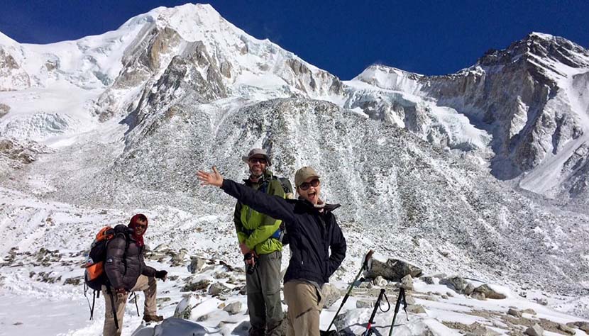
Manaslu Circuit Trek is one of the best off-the-beaten-path treks in Nepal that takes you around the world’s eighth highest peak, Mt. Manaslu (8163m).
This 18 day Manaslu Circuit Trek takes you from the cool and peaceful valleys and lowlands to the high and chilly passes around Manaslu. This scenic and culturally rich trail offers breathtaking views of Manaslu, Annapurna, Gangapurna, Himal Chuli, Ganesh Himal, Himlung, Kang Guru and many other peaks. You will begin the trek by following the Budhi Gandaki River, and pass through cultivated fields, subtropical forests and deep gorges to climb up to the Larke La Pass (5167m), the highest point on the trek. On the way, you will have a chance of encountering some of the Himalayan wildlife including Tahr (Mountain Goat), Agali (Blue Sheep), Pika (Highest living Mammal), Himalayan Marmots and even the elusive Snow Leopard.
The Manaslu Himal rises in the north of the Gorkha District in mid-western Nepal. The region contains some of the most beautiful and dramatic scenery in the Himalaya. The south is peopled by Hindu Newars and Buddhist Gurungs; the north is home to an old Gurung and a Tibetan community: speaking two independent dialects. Engaging in this rich cultural mix is one of the highlights of this trek.
The topography demands much up and down walking, making this 170km trail quite demanding: and calling for good initial fitness. The up route passes through natural forest and farmland with enticing mountain vistas glimpsed on occasion. Beyond ‘New Bridge,’ the valley gradually curves to the west between dramatic mountain ranges to the north and south. Manaslu is first revealed on the 8th day. A rest day at Samagaon offers a visit to the Pungyen Nunnery below Manaslu or a walk to Manaslu Base Camp. A three day trek then leads to the Larkya La (5 160m/16 930ft) beyond which the trail drops into the Annapurna Region through dramatic glacial scenery to warmer villages below. Descend to Tal for a last night before taking a jeep back to Kathmandu.
Explore our Tsum valley trek which is recently opened for the trekkers who wants to experience more of the scenic views and the beautiful landscapes.
Best Season for Manaslu Circuit Trek
The best times of the year to perform the Manaslu Circuit Trek are during spring (March to May) and autumn (last week in September to mid-December) seasons. The peak season is in October. During these seasons, the weather remains stable and the mountain views are good leading to the best experience.
Manaslu Circuit Trek Difficulty
Manaslu Circuit Trek is a physically demanding trek into the remote parts of western Nepal. While this trek can be performed with little to no prior trekking experience, good fitness levels and abundant stamina are recommended.
Manaslu Circuit Trek Permits
Manaslu Conservation Area Permit (MCAP)
MCAP cost for SAARC national in Nepali currency: NRS. 200 per person
Annapurna Conservation Area Permit (ACAP)
ACAP cost for other Nationals in Nepali currency: NRS. 2,000 per person
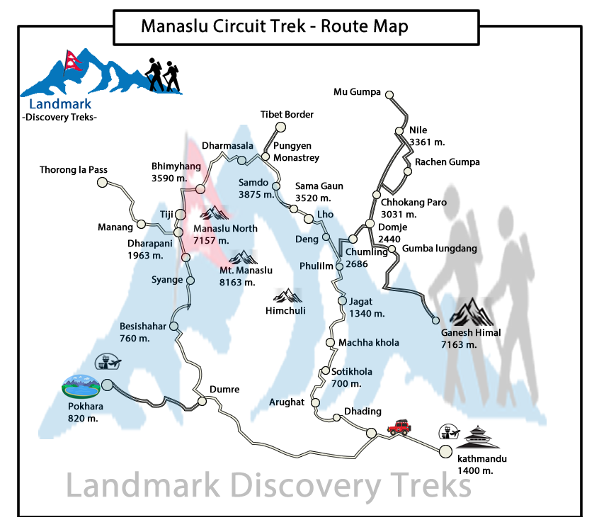
Manaslu Circuit Trek Itinerary
Day 01: Arrival Kathmandu Tribhuvan Airport (1 300m/4 260ft). We will meet and transfer you to your hotel.
Day 02: In the City: Kathmandu Valley Sightseeing Tour OR A day at leisure. Trek preparation.
Day 03: Kathmandu – Arughat (670m/2 200ft) – Soti Khola (710m/2 330ft), Machha Khola (890m/2 920ft),150km, 8-9 hrs drive
Day 04: Machha Khola – Dobhan (1 000m/3 280ft), 6-7 hrs
Day 05: Dobhan – Philim (1 590m/5 220ft), 6-7 hrs
Day 06: Philim – Deng (2 360m/7 750ft), 6-7hrs
Day 07: Deng – Namrung (2 660m/8 730ft), 6-7 hrs.
Day 08: Namrung – Lho (3 180m/10 430ft), 4-5 hrs
Day 09: Lho – Samagaon (3 530m/11 580ft), 5-6 hrs
Day 10: Sama: Rest and exploration day: Birendra Tal / Pungyen Gompa / Manaslu Base Camp
Day 11: Samagaon – Samdo (3 860m/12 660ft), 3-4 hrs
Day 12: Samdo – Dharamsala/Larkya Phedi (4 460m/14 630ft), 3-5 hrs
Day 13: Dharamsala – Larkya La (5 160m/16 930ft) – Bimthang (3 720m/12 200ft), 7-9 hrs
Day 14: Bimthang – Gho (2 560m/8 400ft), 5-6 hrs
Day 15: Gho – Dharapani (1 920m/6 300ft) – Tal (1 700m/5 580ft) 3-4 hrs
Day 16: Tal – Besi Sahar (760m/2 495ft) – Kathmandu (1 300m/4 260ft), 190km, 7-8hrs drive
Day 17: Final Departure: Transfer to Tribhuvan International Airport for your flight to your onward destination.
NB: Cloud and turbulent weather along the mountain ranges is common and may lead to internal mountain flight delays or cancellations. We suggest you add at least one extra day fter your trek before flying out of Nepal.
After completing passport, immigration and visa requirements, we will meet you outside the terminal building (look for your name board) and transfer you to your hotel: afternoon free. Evening: a welcome dinner, introduction to your guide and a briefing on the trek with a check on necessities. Overnight at hotel.
Take a day tour to five of the Kathmandu Valley’s cultural world heritage sites: Swayambhunath, the famed “monkey temple”; the city’s historical Durbar Square with ancient temples, unique art and architecture, plus the chance to see the Kumari (living goddess); Patan’s Durbar Square; the Hindu temple Pashupatinath and Bouddhanath, the world’s largest stupa.
A car and driver will take you to each site-entrance and wait for you. (Entry tickets and lunch are not included.)
Drive west from Kathmandu towards Pokhara through Middle Hill rural communities to Malekhu. Cross the Trisuli and head north to Dhading Besi. A slow, rutted, dirt road then heads NW: over the Gola Bhanjyang (with panoramic views of the Baudha and Ganesh Himals).
(Beyond this occasional views of Ganesh IV and VI will be seen above the valley walls as far as Khorlabesi. Shringi Himal appears from Salleri to Philim, from where Baudha Himal is also visible. Manaslu is first seen on the walk up to Lho.)
Drive on to Arughat and the Budhi Gandaki that drains the Manaslu–Tsum region. A further ~4 hrs drive up the west bank leads to Machha Khola. Overnight in Machha Khola.
Cross the Thado Khola, descend stone stairs then follow the bar to Khorlabesi (970m, coffee and tobacco crops). The GHT trail through Gorkha (and Barpak, epicentre of the first quake on 25/04/15) crosses our trail, heading east from Manaslu to the Langtang then Everest regions.
Enter a lush narrow gorge constricting the river’s progress. Cross a landslide with a dicey path, before the three hot spring spouts in Tatopani (930m). Climb a ridge then cross the Budhi Gandaki (to avoid a cliff face and waterfalls). A staircase then leads to a landslide before climbing to a ridge; and Dobhan. Overnight in Dobhan.
Exit over the Dobhan Khola, then follow the east bank to the hamlet of Thulo Dhunga (1 840m); above cataracts. Later the gradient lessens, the valley opens and the water is placid at Yaruphant (1 170m). Cross the Yaru Khola (from Ganesh II and VI) on an old suspension bridge then climb to the teahouses at Thado Bharyang. Cross back to the west bank and ascend gently to the old paved village of Jagat (1 410m): entrance and checkpoint to the Manaslu Conservation Area.
Cross a tributary before a cliff-side trail to Salleri: with views of Shringi Himal (7 187m) to the north. Descend to Sirdibas; and the first symbols of Buddhist culture. A final bridge beyond Ghatta Khola (1 480m, water mills) to the east bank, leads to a steep climb up to Philim: a prosperous Gurung village set amongst millet and maize fields; see the Chholing Sandu Gompa. Overnight in Philim.
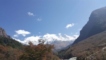
The trail winds through scrub and lush grasses up the beautiful narrowing valley to the high millet fields of Chisopani, then Ekle Bhatti (1 600m, one house). Gradually descend, past a spectacular waterfall, into the narrow lower gorge: and a junction, left to ‘New Bridge’ and the Larkya La, (right to the Tsum Valley).
Cross the bridge and follow the trail as it curves NW into the Manaslu Valley. A broader trail gradually rises, through bamboo forest to Deng [1 800m, entry to Kutang/Lower Nupri (‘Nubri,’) - within Tibet until the 1840s]. The people are Gurungs who speak a unique dialect, practice Buddhism and still trade with Tibet. Overnight in Deng.
Cross to the E bank and climb to Rana (1 980m). Tight switchbacks end at a log-bridge tributary-crossing before an isolated water mill. The trail then gently descends to Bihi Phedi; still high above the river.
Undulate above the river before dropping to cross the Serang Khola (far below the Serang Gompa) and later enter an S-bend between basalt walls. Rocky crags rise to the E, with a waterfall high above fields of wheat and maize. The valley broadens as it curves W: cross to the S bank shortly before a kani into attractive Ghap (2 250m); for lunch.
Ascend, through bamboo and bird-filled forests. Cross to the N bank past sheer rocky walls. The river then becomes constricted by hard rock; a short wooden bridge (over a natural rock tunnel) returns to the south bank as the water thunders below. A steep 1 hr trail leads up and away from the river to Namrung. En-route are views of the substantial Tum Khola from the Tibetan highlands: that adds its volume to the lower river at its (unseen) confluence. Namrung is a permit checkpoint. Overnight in Namrung.
This is the entrance to Upper Nupri (western mountains). Its people, formerly from Tibet, speak a unique dialect, favour chubas as common dress and continue to trade with Tibet.
The trail through maize and barley fields to Barsam is gentle. (Night guard towers, manned to scare off marauding bears, dot fields from Deng to Shrip). Climb more steeply to Lihi (2 900m, homes are grouped in clusters beneath one shingled roof). Ganesh II appears east of the valley and landmark chortens herald views of Himal Chuli (7 893m) south of the trail.
The trail then enters a side valley, crosses the Hinang Khola (and a trail to the Himal Chuli BC). It climbs steeply to a detailed chorten land marking the ice walls of Himal Chuli to the south. Beyond are the clustered houses fields and apple orchards of Sho (2 960m). Good views continue as the trail ascends to the hamlet of Shrip.
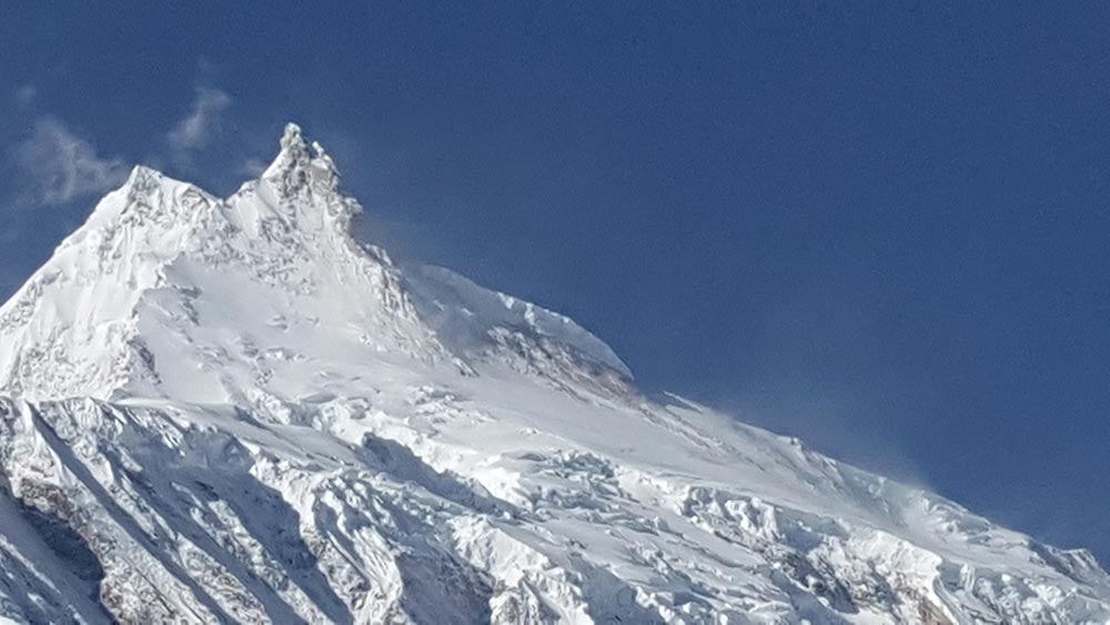
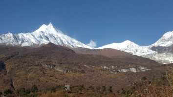
From Shrip, the trail curves up towards Lho: and reveals the 8th highest peak: Manaslu (8 156m/26 760ft, which, from the Sanskrit manasa– ‘intellect’ or ‘soul’ gives ‘Mountain of the Spirit’); Manaslu North and Naike Peak. A steep climb ends on the ridge in the attractive village of Lho.
The stone houses are shingled and many have distinctive wooden decks. The imposing Ribung Monastery above the village houses ~150 monks. A kani beyond the village, past an ancient mani wall and chortens, offers the best spot for dusk and dawn pictures. Overnight in Lho.
The Budi Gandaki flows deep in the valley north of the kani and viewpoint. Descend steeply to cross the Damonan Khola tributary. Then follow a stream up through glorious mixed forest. A short final climb leads to a plateau: and the badly deforested region around Shyala (3 520m). Peaks rise on all sides: Himal Chuli (7 893m) and Peak 29 (Ngadi Chuli, 7 873m) to the south; Manaslu and glaciers ahead; snow-capped peaks to the north and west.
Later, cross a new bridge over the Numla Khola that drains Manaslu’s Pungyen Glacier. Beyond, a trail heads (left) to Pungyen Gompa on the glacier. Walk down the attractive, broad valley past a school and extensive barley and potato fields to a large chorten.
Enter Sama through a yellow kani and pass a gompa (smothered in mani stones) to rows of low stone dwellings with front courtyards.
Only upper Manaslu and the Naike ridge can be seen from the village. Overnight in Sama.
Sama is Nupri’s regional centre. Explore its architecture, customs and home industries. Items made for trade in Tibet include cloth for chubas and woven rugs using local or imported yarn from sheep and goats. Horses, Yak and Dzopkyo (yak-cow cross) herds are bred for trade.
Beyond and above the village is the 700 hundred year old Kargyu Chholing Monastery (or Labrang: Lama’s Place); its architecture is unique and has fine woodwork. The largest of its eight temple buildings is the Pemba Chholing Gompa, with an impressive statue of Guru Rinpoche. It is owned by the Nyingma Buddhist sect whose Lamas are permitted to marry; and live within the complex.(Regrettably much of the Labrang was destroyed in a fire on 18 February 2015.)
A short walk beyond the monastery leads to the Birendra Tal (3 450m, lake) below the Manaslu Glacier. View it from a hilltop or drop to a stony beach which offers striking views of the terrain. 1½hrs
A demanding trail above the far side of the lake (reached from a path at the bridge over the outflow stream) climbs ~1 200m past the glacier’s snout to the Manaslu Base Camp (4 900m), 5-6 hrs
A trek to the Pungyen Nunnery (3 870m), on a ridge above the Pungyen Glacier; offers superb views of the Nadi ice-ridges and Manaslu towering over the gompa.
To reach the gompa, return towards Shyala, passed the school to the turnoff. The trail heads over a ridge above the Numa Khola and drops onto the Pungyen Glacier. Walk to the ridge on which the gompa is built. ~2½hr. The route can be very cold and slippery; take refreshments.
In 1953, much of the gompa was destroyed in an avalanche – and was only recently rebuilt. Blame for the avalanche was apportioned to the first Japanese (unsuccessful) expedition to Manaslu. They were the first to conquer it – in 1956. 5-6hrs Return to Sama for the night.
A pleasant and easy walk today. Pass the lake, the BC trail and several mani walls. Birch and juniper stands cover the hills surrounding Kermo Kharka above the now north flowing Budhi Gandaki. Later, a stone wall across the valley separates the Sama and Samdo herds. Further on, a spur rises ahead, between the river from the Sonam/Mayol Khola off the Sonam Glacier NE of the trail. Drop to cross the Budhi on a wooden bridge just below their confluence and then the Sonam Khola.
Climb steeply up the spur to a stone arch amid fields. Walk to a white kani at the entrance to Sama: a cold, cluster village against a ridge. Tibetan residents had summer grazing rights to this region, but with the political changes in the late 1950s they fled to Sama and constructed the slate roofed stone dwellings. It is a yak and goat herding post on the trade route to Kyirong; with holding pens amid fields behind the village. This is the last village in Gorkha. The next is Gho in the Manang District (Annapurna region). Several kharkas have teahouses in between.
The vegetation has now changed to alpine low grasses, rhododendron and juniper scrub. After lunch, follow yak tracks up the steep flag bedecked spur behind the village for magnificent 270o views. To the east, along the border, is Sonam Peak (6 335m) with an unusually demarcated glacial moraine. Ahead is the Sama Valley and ranges to the south of Manaslu (hidden by a rocky peak). The view to the west shows tomorrow’s route to Bimthang – and Larkya La along the Larkya Glacier. In the foreground the Syacha Glacier from Manaslu North curls around the foreground peak. Overnight in Samdo.
Drop for the final crossing of the Budhi Gandaki below the former Larkya Bazaar site (3 650m, a popular seasonal trading post before the border was closed). The diminished stream flows from the northern Pana Danda Valley: where a trail leads to two passes to Tibet. Our trail heads west and climbs gently through low scrub above the Syacha Khola and glacier. Its descent from Manaslu North can be seen up that valley.
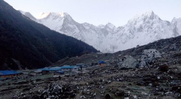
The trail steadily ascends towards the Larkya Glacier’s snout beyond the hidden Larkya Phedi which gradually comes into view. This seasonal kharka had a kitchen with dining room, 15 small double rooms in two rows and two tunnel tents; each with eight beds plus a third for trekking staff. Better views of the Naike (6 291m) and Larke (6 249m) peaks can be had from higher up the side of the valley. Rest and overnight in Dharamsala.
Larkya La involves an 800m, 3-5 hr ascent (when snow free) and a 1 500m, 3-4 hr descent to Bimthang. It can be bitterly cold if windy; snow and ice will demand more time. Snow poles mark the route along the moraine: it is not difficult or steep, but is long and everywhere rocky underfoot.
A pre-sunrise start begins with a gentle ascent to a ridge before a long ascent to the vast, jumbled moraine field. Ahead, Pawar Peak on the northern border wall of Cheo Himal and Larke Peak on the southern Larkya Himal gradually appear above the moraine. Walk past the first of four small scattered lakes. Finally a steady pull curves towards Larke and the first group of summit flags. The reverse view overlooks the trail, distant Sonam Peak and ranges into Tibet. The Cheo and Larkya Himal ridges block views to the north and south.
Ahead, a moraine ridge, separated from the Larke wall by a parallel gully leads, for ~30 min, to a second set of landmark flags: and the boundary between the Manaslu and Annapurna conservation regions. They also overlook astounding views into a huge semi-circular basin ringed by a mix of magnificent ice peaks and eroding grey rocky walls. Within, three glaciers flow towards the southwest corner.
From north to west, the landmark peaks are Pawar (6 620m), Cheo (6 820m), Himlung (7 126m), Gyaji Kung (7 030m) and Kang Garu (6 981m). Further east Annapurna II (7 937m) rises above lesser peaks.
From the flags, drop steeply off the moraine and then carefully descend the, steep switchback trail, over loose gravels: to grassy Dangboche Kharka (4 450m) below your feet.
Rest frequently to marvel at the results of the valley’s glacial action. The Pawar Himal produced the Salpudanda and Ponkar Glaciers which then merge (trapping the medial Ponkar Tal). The third, Kechakyu Glacier, then merges with the others at the western end of the valley forming the Bimthang Glacier whose outflow swells the Dudh (milk) Khola: forming the border between the Manaslu and Annapurna Himals.
The gradient from Dangboche Kharka is more comfortable. Descend beside the lateral moraines into a narrow valley and a T-junction: north and up to explore the Ponkar Tal (3 960m); south a gentle walk into the lovely Bimthang (plain of sand) Valley – and attractive teahouses ahead. Beyond, the northeast face of the Manaslu – Chuli Ridges rise high above forest. The Kechakyu Himal guards the trail to Ponkar Tal.
Bimthang has become the summer grazing settlement for the Samdo population. It was an important trading post before the closure of the Tibetan border. Tibetan Khampa warriors had a centre here in the 1970s. Overnight in Bimthang.
Walk across the Bimthang Plain; then begin a 1 200m descent to Gho. Cross the stony glacier before climbing its far moraine to enter magnificent pristine oak, rhododendron and pine forests. Views of the Manaslu – Chuli Range continue along the route. Descend along the Dudh Khola’s west bank to Hompuk (3 430m, a rock shelter near a bridge) then attractive Sangura Kharka (3 430m). Drop steeply to cross the Suti Khola to Karche (2 700m) for lunch. Follow the river’s S bend then negotiate a flood related landslide and a steep ridge climb past terraced fields to the charming Gurung village of Gho. Overnight in Gho.
After breakfast, descend through farmlands to the old paved village of Tilje (2 300m). Cross to the river’s east bank and descend rapidly into the Marsyangdi Valley through scrub forest. Return to the west bank before Thonje (1 965m) and then, in Thonje, cross the descending Marsyangdi Khola (from Manang) prior to their confluence. Join the new road from Manang on the Annapurna Circuit and descend to bustling Dharapani for lunch.
After lunch follow the road down to Khotro (1 860m) then cross to the river’s eastern bank to trek down the steep trail to the attractive and quieter village of Tal. Here the river is placid, flowing between wire mesh gabions. Overnight in Tal.
After an early breakfast, take a jeep for the rutted descent (passing the development of an impressive new hydro electric scheme) to Besi Sahar. Then, travel east on the paved road back to Kathmandu. Overnight in Kathmandu.
[Alternatively, drive west to explore the lake city of Pokhara (106km), south of the Annapurnas. Return to Kathmandu by plane or tourist bus.]
Transfer to Tribhuvan International Airport for your flight to your next destination.
I completed the Manaslu Trek in Sept. 2022 with Landmark Discovery Treks. If you are looking for a beautiful hike away from the crowds , then this is for you. The organisation was first class. My guide Badri was brilliant, looking after all my needs. I am 77 and had no problem completing the route. Therefore anyone who is reasonably fit will enjoy it.
Gideon Malherbe
5th Nov, 2022
We had an amazing experience walking the Manaslu Circuit Trek. We were a group of 10 people from Poland. Badri was our guide. The trip was very well organised and thought through in order to give us plenty of time to adapt gently to the altitude. Badri was looking after the group every step of the way. We also became friendly with the group of porters, which made the trek very enjoyable. I'd recommend Landmark Discovery Trek company to anyone, who'd like to experience the beauty of Himalayas. Their years of experience and great knowledge about the mountains is incredible and safety of their clients is a priority. Thank you Badri for an amazing experience 🙂✌
Olga
5th Nov, 2022
I have been on Manaslu trek in October 2022. It was wonderful time there with our the best guide in the world - Badri Panta. Apart breathtaking landcapes everywhere and wonderful weather (2 weeks sunny days), Badri was really professional, responsible, smiles, funny, patient and carying guide. He took care for everyone in every situations. He fulfiled our needs. His knowledge about mountains was very pro. Every part of the treking was organized on very high level. In all good conscience I can recommend Badri Pant with his porters to every trip in Himalayan.
Joanna
9th Nov, 2022
Our group of three people booked a 16-day tour with Prem Panta from Landmark Discovery Treks for April 2016. We had a great trek and Prem was very helpful and considerate throughout the trip, especially when I fell sick.
After living and working in Nepal for a year, I knew that there hundreds of trekking companies and guides, and many of them do not take into consideration guests' own interests or safety. Prem is the opposite. Prem is a good people's person and he really understood when to give us our own space when walking through the amazing landscapes. He is also very patient as we all three are nature conservationists and the boys in particular spent (almost too much time) identifying birds!
I can highly recommend Prem and Landmark Discovery Treks.
_______
In Finnish: Nepalissa vietetyn vuoden jalkeen paadyimme varaamaan 16-paivan vaelluksen Landmark Discovery Treks-yrityksen kautta. Suosittelen yritysta ja opastamme Prem Pantaa lampimasti!
Laura L
25th Apr, 2022